• facebook
  • Twitter
  • Linkedin
  • Youtube
  • Linkedin Group
  • Post a Job
  • Post an Ad
  • Post an Event
  • Post a Directory Listing
  • Post a Press Release
  • Media Kit
  • My Account
  • Login
GoGeomatics
  • MAGAZINE
    • BIM & GIS
    • Community
    • Conference news
    • Earth Observation
    • Education & Careers
    • GEOAI
    • Announcements
    • Reality Capture & Lidar
    • Science
    • Technology
  • Directories
    • ASSOCIATION
    • INDUSTRY
    • EDUCATION
    • Open Data
  • EVENTS
    • GeoIgnite Events
    • Events Calendar
    • GoGeomatics Meetups
  • Services
    • Advertising
    • Marketing
    • Post a Job
    • Post an Ad
    • Post an Event
    • Post a Press Release
    • Post a Directory Listing
    • Media Kit
    • Web Design
  • Find a Job
  • Volunteer
    • Start a GoGeomatics Group
    • Editors & Writers Group
  • About Us
    • About Us
    • Contact Us
    • Frequently Asked Questions
  • Videos
Homesearch

search

No Picture
Community

SNRC: UAV Integration Highly Valued in Canadian Marketplace

7 April 2016 Stuart Krause | 2015

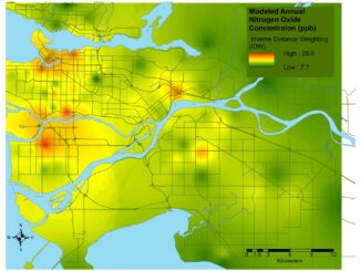
Due to a foreseeable increase in the demand for UAV acquired aerial imagery in resource management, various firms are already operational and are planning further investments in UAV technology. One such consulting firm implementing UAV […]

No Picture
Education & Careers

GIS Certification: AOLS Certificate of Registration

5 April 2016 Dianne Gray | achievement

  Among the various types of GIS and Geomatics certifications available to Canadians, The Association of Ontario Land Surveyors (AOLS) offers Certificates of Registration to geomatics professionals in the province of Ontario, who become designated […]

Education & Careers

Professional Certification: Population Health Data Analysis in British Columbia

22 March 2016 Anders Erickson | 2016

Population health research is inherently interdisciplinary, multifaceted and firmly rooted in the evolving connections between place, time and related socioeconomic processes. To excel in this rapidly diversifying field requires a broad range of skills. The […]

||
Community

UAV Technology in the Canadian Forestry Sector

21 March 2016 Stuart Krause | 2015

The Unmanned Aerial Vehicle (UAV) industry is soaring! Civilian drones are being applied in various global industries ranging from agriculture and mining to construction and film production. The potential of the application of UAVs in […]

No Picture
Education & Careers

Find Your GIS & Geospatial Job: Career Seminar Ottawa April 9th

21 March 2016 GoGeomatics Canada | 2016

Finding a job in geospatial technology can be difficult. That’s why GoGeomatics Canada is bringing back our popular Career Seminar to Ottawa to give job seekers the tools and techniques that will put them ahead […]

No Picture
Newsmakers & Press Releases

Esri Canada Named Gold Standard Winner among Canada’s Best Managed Companies

16 March 2016 GoGeomatics Newsmakers | 2012

Esri Canada, the country’s leading enterprise geographic information system (GIS) solutions provider, has been named a Gold Standard winner among Canada’s Best Managed Companies, a prestigious national award program sponsored by Deloitte, CIBC, National Post, […]

No Picture
Newsmakers & Press Releases

An API for the World’s Weather & Climate Data

15 March 2016 GoGeomatics Newsmakers | 2012

Planet OS is excited to announce the launch of our first API designed specifically for geospatial and Earth observation data. The Planet OS API provides developers, researchers, and climate specialists with a new tool for […]

No Picture
Community

Location Encoding Systems – Could geographic coordinates be replaced and at what cost?

11 March 2016 Emmanuel Stefanakis | 2015

Geocoding is the process of converting a street address into a physical location that can be described with a pair of geographic coordinates. It is estimated that over 40% of the world population is physically […]

Posts pagination

« 1 … 11 12 13 … 47 »

Events

Notice
There are no upcoming events.

View All Events

Services

  • Post a Job
  • Post an Ad
  • Post an Event
  • Post a Directory Listing
  • Post a Press Release
  • Media Kit
  • My Account
  • Login

Jobs

Post a Job
  • Canada Maps and Poster Gallery Volunteer Leads — GeoIgnite 2026
    remote
  • GIS & Data Analytics Lead
    Beaumont, AB
  • Lead Surveyor, Projects/Arpenteur-géomètre principal, projets; arpenteuse-géomètre principale, projets
    North Bay, Thunder Bay
  • Senior GIS Developer
    Calgary, AB
View All Jobs
  • Directories
    • Associations Directory
    • Industry Directory
    • Education Programs
    • Open Data
  • Volunteer
    • Start a GoGeomatics Group
    • Editors & Writers Group
  • About Us
    • GoGeomatics Media Kit
    • Who We Are
    • Contact Us
    • FAQ’s
    • Advertising
    • Marketing
  • Subscribe
GoGeomatics
GoGeomatics is the largest and most popular communications hub promoting the Canadian geospatial community. The business was incorporated in 2011. GoGeomatics hosts over 100 fun, free, location technology networking events each year in cities across Canada.

© 2025 GoGeomatics

  • facebook
  • Twitter
  • Linkedin
  • Youtube
  • Linkedin Group