
Community
The Canadian Council on Geomatics (CCOG) has been around for over 40 years. Despite that, many people in geomatics aren’t aware of the significant role this federal-provincial-territorial government organization plays in the sector. To help […]

The City of Surrey launched its open data program as part of its commitment to an open, transparent and accessible government. The new Open Data Catalogue comprises more data sets than any other municipality in […]

Canadian students are busy getting ready for the start of a brand new school year. And at six schools across Canada, geography programs are preparing to integrate a brand new collaboration into their programs – […]
The United Nations Committee of Experts on Global Geospatial Information Management set to clear the path for location based standards to enhance sustainable development across the World. The Fourth Session of the United Nations Committee […]
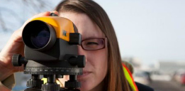
Are you considering launching a career in land surveying? Wondering what this career has in store? Read on to learn about the job description, education, skills, expected salary and more to find out if this […]
“Not good enough damn it! Not good enough!” – Jean-Luc Picard Jonathan Murphy, Managing Director of GoGeomatics asked me many months ago if I’d pen a guest blog entry on the question of Identity […]
On February 6-9, 2014, Dr. Claus Rinner, Associate Professor of Geography and Program Director of the Master of Spatial Analysis at Ryerson University and his team of four students attended the 2014 Spatial Knowledge Information […]