travel
Ten Years Later: Interview with Wendy MacIsaac one of Canada’s Top Surveyors
Ten years ago, GoGeomatics interviewed Wendy MacIsaac of Midwest Surveys Inc. in Calgary, Alberta, about her career and being a…
International Geospatial Briefing Oct 25th: 1. Interactive map of hidden archaeological landscapes. 2. GIS helps asylum seekers 3. Extent of California oil spill. 4. Mapping Bogota’s neighbourhoods 5. Map Tools international travel requirements 6. New York new subway map 7. GeoSLAM maps underground refugee shelter from Spanish Civil War
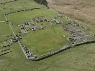
This Interactive Map Lets Users Explore England’s Hidden Archaeological Landscape Attention all history enthusiasts, Historic England has created a new…
Lyon, Montreal, Torbay and beyond: Rodolphe Devillers seeks geospatial answers to environmental problems
This series first started with three career profiles linked to COGS in Lawrencetown, NS, and then moved west to Victoria,…
Where can you meet a COGS GIS Grad? Anywhere in the world
What can you do with a background in Geospatial? Oh, the Places You Will Go! A background in geospatial assuredly…
M.A. or M.Sc. Opportunity – Environmental Assessment and Resource Mgt
M.A. or M.Sc. Graduate Research Opportunity Department of Geography and Planning University of Saskatchewan Opportunity: The Department of Geography…
May 5: Vancouver: NRCan Discovery Centre Science Open House
Come talk to scientists in Canada’s oldest science agency at a Canada 150 Open House. Visitors can check out over…
One of the Best Geomatics events in Canada: GeoAlberta 2017
I had a chance to attend the 2017 GeoAlberta conference earlier this month in Calgary, Alberta. This was my first…
Master’s Thesis Student Recruitment: Amphibious Housing in Vietnam
University of Waterloo searching Funded Master’s (MA or MES) research project Dr. Carrie Mitchell (UW-Planning) and Dr. Brent Doberstein (UW-Geography…
Canadian Remote Sensing Training: Summer School – Montreal 19 June 2017
The Earth Observation (EO) Summit 2017 brings together in one exceptional event the 38th Canadian Symposium on Remote Sensing (CSRS),…
Ten Interesting Facts about the Geography of Canada
This year Canada will celebrate its 150th birthday on July 1st. Most of you, like me, will be out celebrating…
Atlantic Canada: COGS: Geomatics Professionals Coming to Discuss High Resolution Coastal Mapping
High Resolution Coastal Zone Mapping This collaborative effort by GANS & the CIG will engage the geospatial community & increase awareness on the value…
what3words adopted by six national mapping agencies
what3words, the multi-award winning location reference system, has today announced that six national mapping agencies have adopted 3-word addresses. Used…