• facebook
  • Twitter
  • Linkedin
  • Youtube
  • Linkedin Group
  • Post a Job
  • Post an Ad
  • Post an Event
  • Post a Directory Listing
  • Post a Press Release
  • Media Kit
  • My Account
  • Login
GoGeomatics
  • MAGAZINE
    • BIM & GIS
    • Community
    • Conference news
    • Earth Observation
    • Education & Careers
    • GEOAI
    • Announcements
    • Reality Capture & Lidar
    • Science
    • Technology
  • Directories
    • ASSOCIATION
    • INDUSTRY
    • EDUCATION
    • Open Data
  • EVENTS
    • GeoIgnite Events
    • Events Calendar
    • GoGeomatics Meetups
  • Services
    • Advertising
    • Marketing
    • Post a Job
    • Post an Ad
    • Post an Event
    • Post a Press Release
    • Post a Directory Listing
    • Media Kit
    • Web Design
  • Find a Job
  • Volunteer
    • Start a GoGeomatics Group
    • Editors & Writers Group
  • About Us
    • About Us
    • Contact Us
    • Frequently Asked Questions
  • Videos
HomeUBC

UBC

||
Community

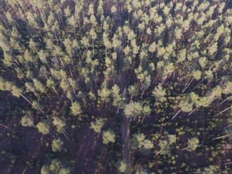
UAV Technology in the Canadian Forestry Sector

21 March 2016 Stuart Krause | 2015

The Unmanned Aerial Vehicle (UAV) industry is soaring! Civilian drones are being applied in various global industries ranging from agriculture and mining to construction and film production. The potential of the application of UAVs in […]

No Picture
Education & Careers

Remembering Roger Tomlinson & Early History of GIS in Canada

9 February 2016 Robert Maher | 2013

It’s two years now since Roger Tomlinson passed away.  Roger’s and my career path have crossed several times over the last fifty years and what follows is my remembrance of the man and some of […]

No Picture
Education & Careers

Jobs: Career Challenges for Canadian Students and Recent Graduates in GIS

25 January 2016 Dianne Gray | 2013

The Challenges As a recent graduate (2013) of GIS training at BCIT in Burnaby in addition to an Honours Bachelor of Science degree at UBC-Okanagan in Kelowna, I find that students and recent graduates can […]

||
Community

Local Action & Geomatics: the Gowgaia Institute on Haida Gwaii

27 November 2015 Robert Maher | 2015

This blog is a sequel to last month’s discussion on ‘think global, act local‘. It looks at the the Gowgaia Institute and their use of Geomatics technologies, including an interview with John Broadhead a director […]

No Picture
Technology

Web Mercator: the de facto standard, the controversy, and the opportunity

23 September 2015 Emmanuel Stefanakis | 2014

Four hundred and fifty years ago, the Flemish geographer and cartographer Gerardus Mercator presented the most popular map projection ever. It became fairly the standard projection for nautical maps because of its ability to represent […]

No Picture
Community

Beyond the Outer Shores

22 September 2015 Robert Maher | 2012

For over fifty years, the islands off the coast of British Columbia and Alaska have been called ‘the outer shores’. This goes back to the pioneering exploration by Ed Ricketts, an ecologist, who gained renown […]

No Picture
Newsmakers & Press Releases

WSP to Acquire MMM, a Leading Canadian Engineering Consulting Firm

28 August 2015 GoGeomatics Newsmakers | 2014

WSP Concurrently Announces a $175 Million Bought Deal Public Offering and a $125 Million Private Placement WSP Global Inc. (TSX:WSP) (“WSP” or the “Corporation”) is pleased to announce that it has entered into an arrangement […]

No Picture
Community

Finding Common Ground: CGCRT & GeoAlliance Canada

27 August 2015 Robert Maher | 2015

The full title of Ted Chamberlin’s 2003 book is ‘If this is your land, where are your stories ? Finding Common Ground ‘. This title comes from a Gitksan story told to Chamberlin by Peter […]

Posts pagination

« 1 2 3 4 »

Events

Notice
There are no upcoming events.

View All Events

Services

  • Post a Job
  • Post an Ad
  • Post an Event
  • Post a Directory Listing
  • Post a Press Release
  • Media Kit
  • My Account
  • Login

Jobs

Post a Job
  • Canada Maps and Poster Gallery Volunteer Leads — GeoIgnite 2026
    remote
  • GIS & Data Analytics Lead
    Beaumont, AB
  • Lead Surveyor, Projects/Arpenteur-géomètre principal, projets; arpenteuse-géomètre principale, projets
    North Bay, Thunder Bay
  • Senior GIS Developer
    Calgary, AB
View All Jobs
  • Directories
    • Associations Directory
    • Industry Directory
    • Education Programs
    • Open Data
  • Volunteer
    • Start a GoGeomatics Group
    • Editors & Writers Group
  • About Us
    • GoGeomatics Media Kit
    • Who We Are
    • Contact Us
    • FAQ’s
    • Advertising
    • Marketing
  • Subscribe
GoGeomatics
GoGeomatics is the largest and most popular communications hub promoting the Canadian geospatial community. The business was incorporated in 2011. GoGeomatics hosts over 100 fun, free, location technology networking events each year in cities across Canada.

© 2025 GoGeomatics

  • facebook
  • Twitter
  • Linkedin
  • Youtube
  • Linkedin Group