vegetation
International Geospatial Digest December 18th, 2023
Automatic digitizing of imagery using QGIS GISCorps volunteer assisting Oracabessa Marine Trust Interactive map shows the locations of over 300…
Observing the Peace-Athabasca Delta and Wetland Climate Stress from Space
In the far northern reaches of Canada’s Saskatchewan Province, the Athabasca River and Peace River flow into the Peace-Athabasca Delta,…
Canadian Geospatial Briefing Nov 1st: 1. Canadians buying homes in climate change danger zones 2. Light pollution from satellites 3. Remote Sensing benefits P.E.I. farmers 4. Ottawa’s heat map 5. Lungs delivered by drone
Canadians are unknowingly buying homes in climate change danger zones, report finds Canadians are buying homes, unaware of the areas’…
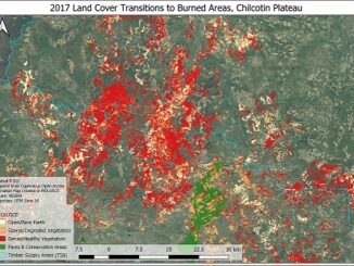
Post-Wildfire Landscape Metrics & Transition Characteristics in Cariboo Regional District, 2017
The summer of 2017 marked one of the worst fire seasons in British Columbia’s history. By October, wildfires had covered…