Government to invest $11.4 million in agricultural technology
The New Zealand government undertakes investment in developing the country’s agritech sector, includes the creation of a horticultural robotics academy and commercializing new products.
Iris Data Science is one of the agritech companies that gets benefits from the government support for its facial recognition technology for animals. This technology tracks livestock movements and provides health information of individual stock.
https://www.stuff.co.nz/business/farming/agribusiness/122197449/government-to-invest-114-million-in-agricultural-technology

Amazon Web Services unveils new space business segment
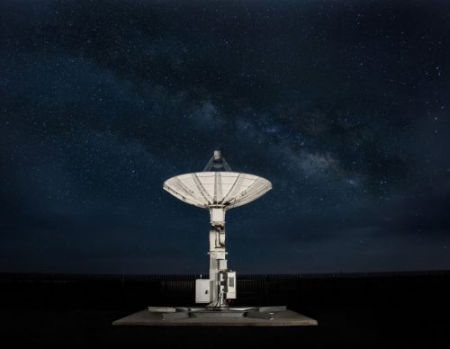
Increasing demand for launch services for satellites and human over the past years results in need for new types of innovation for space-based missions .
Amazon Web Services (AWS) is introducing the Aerospace and Satellite Solutions business segment. This segment will work with customers and partners around the world to accelerate innovation in this industry, including new services establishment for processing space data on Earth and in orbit, space enterprise transformation, supporting government and companies space missions by providing secure and cost-efficient cloud solutions and thinking again about space system architectures.
https://blog.aboutamazon.com/innovation/amazon-web-services-unveils-new-space-business-segment
Measure and Advocate Local Parks Using Geospatial Data
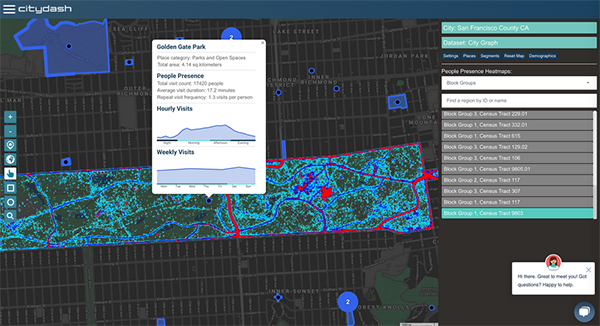
Open spaces such as parks and recreational areas are great places for community engagement and programs and help improve physical and mental health. This year more than ever, people need to spend more time in green spaces for stress relief while maintaining physical distancing.
Some cities in US decided to use new technologies during COVID-19 pandemic. They are using geospatial data to monitor park activity, visits and engagements. This data-driven information helps city leaders in decision making and budgets allocation for programs in parks and recreational areas.
Cities across the United States like San Francisco are using a platform called CityDash.ai to measure the usage of parks such as visitor movement patterns, usage trends and the density of people. This people-intelligence dashboard provides daily analytics for parks and open spaces.
Monthly crowdsourced data points analysis using CityDash.ai interactive visual dashboard and APIs provides accurate and fresh information of the movement and activity of people around the world anonymously.
https://www.govtech.com/health/Measure-and-Advocate-Local-Parks-Using-Geospatial-Data.html
Amazon rainforest the size of Sao Paulo cleared in July in Brazil
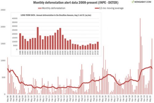
During the month of July, the rainforest clearance area was larger than the city of Sao Paulo. It was a drop in deforestation in July 2020 relative to July 2019 according to Satellite-based deforestation alert system of Brazil’s National Space Research Institute INPE. But 2019/2020 deforestation year, from August 1 to July 31, to be the highest since at least 2007.
It is expected that the primary 2019/2020 estimate — based on analysis of higher resolution data using a system called PRODES — will be published by INPE in October or November.
Deforestation in the Brazilian Amazon has been increased since 2012 and it has accelerated since early 2019. Scientists and NGOs believe that the government causes deforestation acceleration by reducing environmental law enforcement and opening up protected areas to logging, mining and agribusiness.
https://news.mongabay.com/2020/08/amazon-rainforest-the-size-of-sao-paulo-cleared-in-july-in-brazil/?fbclid=IwAR2ZaRbEtt_3PO9feEFz4NelcdsZ7MJdEltPP4GJI92yyRnLnJ365iD0AeE
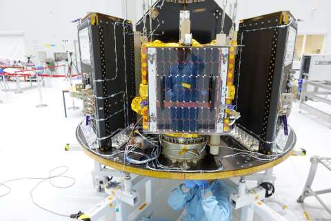
ESAIL Maritime Satellite ready for launch
The ESAIL microsatellite has completed its accommodation on Vega’s new dispenser for small satellites and is ready for launch. A new launch date of 17 August 2020 has been announced by Arianespace for Vega flight VV16. https://www.esa.int/Enabling_Support/Space_Transportation/Vega/Vega_launch_postponed_until_17_August
ESAIL is used for ship tracking around the world by detecting messages that ships radio-broadcast with their automatic identification systems (AIS). ESAIL will deliver data also to the European Maritime Safety Agency for the next generation of global maritime traffic services.
Fisheries monitoring, fleet management, environmental protection and security monitoring for maritime and government authorities and industry are all possible by ESAIL.
The ESAIL high-performance microsatellite was built by LuxSpace under an ESA Partnership Project with the Canadian operator exactEarth. The project was supported by the Luxembourg Space Agency and other ESA member states.
https://space-agency.public.lu/en/news-media/news/2020/ESAIL_ready_for_launch.html


Be the first to comment