• facebook
  • Twitter
  • Linkedin
  • Youtube
  • Linkedin Group
  • Post a Job
  • Post an Ad
  • Post an Event
  • Post a Directory Listing
  • Post a Press Release
  • Media Kit
  • My Account
  • Login
GoGeomatics
  • MAGAZINE
    • BIM & GIS
    • Community
    • Conference news
    • Earth Observation
    • Education & Careers
    • GEOAI
    • Announcements
    • Reality Capture & Lidar
    • Science
    • Technology
    • Between the Poles
  • Directories
    • ASSOCIATION
    • INDUSTRY
    • EDUCATION
    • Open Data
  • EVENTS
    • GeoIgnite Events
    • Events Calendar
    • GoGeomatics Meetups
  • Services
    • Advertising
    • Marketing
    • Post a Job
    • Post an Ad
    • Post an Event
    • Post a Press Release
    • Post a Directory Listing
    • Media Kit
    • Web Design
  • Find a Job
  • Volunteer
    • Start a GoGeomatics Group
    • Editors & Writers Group
  • About Us
    • About Us
    • Contact Us
    • Frequently Asked Questions
  • Videos
Home2016October

Month: October 2016

Between the Poles – The Geoff Zeiss Archives

Be Inspired Awards 2016 reveal rapid adoption of reality capture in construction

31 October 2016 Geoff Zeiss

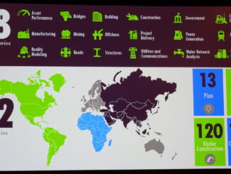
At the Year in Infrastructure 2016 conference in London the Be Inspired Awards set some new records. There were 311 submissions from 22 countries.  Of these 110 were completed and operational projects and 120 were under […]

Education & Careers

GIS Day in Canada: Wednesday, November 16, 2016

31 October 2016 Edgar Rodríguez | 2016

Every year since 1999, the geospatial community has been celebrating GIS Day and this year it is on Wednesday, November 16, 2016.  GIS Day was created by Esri in order to promote grassroots educational events […]

|||||||||
Technology

QGIS & WorldClim: Using Zonal Statistics to Map Temperature Patterns

31 October 2016 GIS Program Langara CS | Alaska

There has never been a time in the history of GIS when so much free, high quality data has been available. As an example, the WorldClim site (http://www.worldclim.org/) offers temperature raster data, on a global […]

No Picture
Newsmakers & Press Releases

NB 911 Bureau Receives Esri Canada Award of Excellence in GIS

26 October 2016 GoGeomatics Newsmakers | 2012

FREDERICTON, Esri Canada User Conference – October 25, 2016 – Esri Canada today presented the NB 911 Bureau, a branch of the New Brunswick Department of Justice and Public Safety, with an Award of Excellence […]

3D data

Development of an open spatially-enabled BIM query language

25 October 2016 Geoff Zeiss

Introduction Building Information Models are comprehensive digital representations of buildings which include 3D geometry and associated data. They are widely used for designing, engineering, and constructing buildings (vertical BIM) and infrastructure (horizontal BIM). Owners are […]

|
Community

Literary Peregrinations: Geographers as Explorers

24 October 2016 Robert Maher | 2013

While I was reading Andrea Wulf’s “The Invention of Nature. Alexander von Humboldt’s New World”. I noted a comment on the back cover by Richard Holmes. Holmes was Professor of Biographical Studies at the University […]

Between the Poles – The Geoff Zeiss Archives

Featured presentation at “Year in Infrastructure”: Buried Utilities Management

23 October 2016 Geoff Zeiss

  2 November 14:30 – 15:30 Dr. Anne Kemp Atkins Fellow and Director, Atkins Dr. Nicole Metje Reader in Infrastructure Monitoring, University of Birmingham (UK) “Out of site and out of mind.” Many of the […]

||||||
Community

Canadian Cartography: GoGeomatics Edmonton Visits the University of Alberta Map Library & Collections

21 October 2016 Jon Murphy | africa

Last night the Edmonton GoGeomatics Group had the chance to explore the amazing collection of historic maps at the University of Alberta (U of A).  Larry Laliberte, the U of A GIS Librarian, introduced the […]

Posts pagination

1 2 3 »

Events

Feb 19
February 19 - February 22

Spatial Knowledge and Information Canada 2026

Feb 19
February 19 - February 22

SKI Conference Canada 2026

Feb 23
7:00 pm - 9:00 pm

Toronto GoGeomatics Networking Social – February 23, 2026

Feb 24
All day

Digital Leadership Day Federal

Feb 24
February 24 - February 26

Government Innovation Week – Federal

View Calendar

View All Events

Services

  • Post a Job
  • Post an Ad
  • Post an Event
  • Post a Directory Listing
  • Post a Press Release
  • Media Kit
  • My Account
  • Login

Jobs

Post a Job
  • Volunteer Editorial Contributor – Be Part of Canada’s Geomatics Story
    Remote
  • Junior Geomatics Field Technician – Technical Surveys
    Montréal, QC
  • GIS Specialist
    Amherst, Nova Scotia
  • Precast Structural BIM Specialist
    Calgary, Alberta
View All Jobs
  • Directories
    • Associations Directory
    • Industry Directory
    • Education Programs
    • Open Data
  • Volunteer
    • Start a GoGeomatics Group
    • Editors & Writers Group
  • About Us
    • GoGeomatics Media Kit
    • Who We Are
    • Contact Us
    • FAQ’s
    • Advertising
    • Marketing
  • Subscribe
GoGeomatics
GoGeomatics is the largest and most popular communications hub promoting the Canadian geospatial community. The business was incorporated in 2011. GoGeomatics hosts over 100 fun, free, location technology networking events each year in cities across Canada.

© 2026 GoGeomatics

  • facebook
  • Twitter
  • Linkedin
  • Youtube
  • Linkedin Group