• facebook
  • Twitter
  • Linkedin
  • Youtube
  • Linkedin Group
  • Post a Job
  • Post an Ad
  • Post an Event
  • Post a Directory Listing
  • Post a Press Release
  • Media Kit
  • My Account
  • Login
GoGeomatics
  • MAGAZINE
    • BIM & GIS
    • Community
    • Conference news
    • Earth Observation
    • Education & Careers
    • GEOAI
    • Announcements
    • Reality Capture & Lidar
    • Science
    • Technology
    • Between the Poles
  • Directories
    • ASSOCIATION
    • INDUSTRY
    • EDUCATION
    • Open Data
  • EVENTS
    • GeoIgnite Events
    • Events Calendar
    • GoGeomatics Meetups
  • Services
    • Advertising
    • Marketing
    • Post a Job
    • Post an Ad
    • Post an Event
    • Post a Press Release
    • Post a Directory Listing
    • Media Kit
    • Web Design
  • Find a Job
  • Volunteer
    • Start a GoGeomatics Group
    • Editors & Writers Group
  • About Us
    • About Us
    • Contact Us
    • Frequently Asked Questions
  • Videos
Home2016

Year: 2016

Between the Poles – The Geoff Zeiss Archives

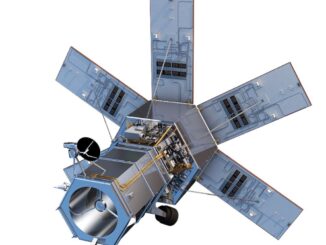
Earth observation satellite Worldview-4 with a resolution of 30 cm launched

19 November 2016 Geoff Zeiss

After a long delay Worldview-4 has been launched.  This means that now the DigitalGlobe constellation of satellites can photograph any spot on Earth more than 4 times per day at a resolution of 30 cm […]

Between the Poles – The Geoff Zeiss Archives

IEA World Energy Outlook projects world warming greater than 2° C based on COP21 committments

17 November 2016 Geoff Zeiss

The International Energy Agency (IEA) has issued its annual World Energy Outlook 2016.  The IEA has examined several scenarios. All the Paris COP21 climate pledges from 190 countries have been incorporated into its main scenario.  […]

Between the Poles – The Geoff Zeiss Archives

Low carbon climate-resilient infrastructure requires private funding

16 November 2016 Geoff Zeiss

A Report by the Global Commission on the Economy and Climate has recommended that since more than 60% of the world’s greenhouse gas (GHG) emissions are sourced from the world’s existing stock of infrastructure, ensuring infrastructure […]

||
Education & Careers

What are the Top Programming Languages in the GIS World?

16 November 2016 Florin-Daniel Cioloboc | 2016

Image source: www.tiobe.com Every now and again we hear about the importance of programming for Geographic Information Systems(GIS) professionals, that is quickly becoming a key in the evolution of one’s career. It is argued that […]

|||||
Education & Careers

The Art of Being a Cadastral Surveyor: Key abilities every surveyor needs

16 November 2016 Manminder 'Meena' Kaur | 3D

The Art of Being a Cadastral Surveyor:  The key abilities every surveyor needs There is an art to being a land surveyor.  Surveyors take extremely accurate measurements with sophisticated tools to create plans that become legal […]

Between the Poles – The Geoff Zeiss Archives

Should utilities be allowed to own distributed energy sources ?

12 November 2016 Geoff Zeiss

At the Smart Gird Interoperability Panel 2016 Grid Modernization Summit in Washington DC the elephant in the room was whether utilities should be excluded from owning renewable power generation. It seemed the topic was so […]

||||||
Newsmakers & Press Releases

2017 Annual Meeting of the Canadian Association of Geographers at York University

11 November 2016 GoGeomatics Newsmakers | 2016

We invite scholars and professionals with geography-related interests to submit abstracts and special session proposals for the 2017 Annual Conference and Meetings of the Canadian Association of Geographers held at York University, May 29- June […]

||
Education & Careers

Technical Writing Tips for GIS and Geomatics Professionals

10 November 2016 Ozair Khan | article for GIS

  You might be a Manager, Consultant, GIS Specialist, Geomatics Engineer, Survey Analyst, Cartographer, Spatial Analyst, GIS Developer or Remote Sensing Analyst. There are some non-technical skills that can make you rise above your peers. […]

Posts pagination

« 1 … 4 5 6 … 34 »

Events

May 3
May 3 @ 8:00 am - May 6 @ 5:00 pm

GEOINT Symposium 2026

May 11
May 11 @ 8:00 am - May 13 @ 5:00 pm

GeoIgnite 2026

May 25
May 25 - May 28

National Surveyors’ Conference 2026

May 27
May 27 @ 8:00 am - May 29 @ 5:00 pm

The Canadian Cartographic Association AGM

Jun 1
June 1 - June 4

CAG/CARTO Annual Meeting 2026

View Calendar

View All Events

Services

  • Post a Job
  • Post an Ad
  • Post an Event
  • Post a Directory Listing
  • Post a Press Release
  • Media Kit
  • My Account
  • Login

Jobs

Post a Job
  • Volunteer Editorial Contributor – Be Part of Canada’s Geomatics Story
    Remote
  • Junior Geomatics Field Technician – Technical Surveys
    Montréal, QC
  • GIS Specialist
    Amherst, Nova Scotia
  • Precast Structural BIM Specialist
    Calgary, Alberta
View All Jobs
  • Directories
    • Associations Directory
    • Industry Directory
    • Education Programs
    • Open Data
  • Volunteer
    • Start a GoGeomatics Group
    • Editors & Writers Group
  • About Us
    • GoGeomatics Media Kit
    • Who We Are
    • Contact Us
    • FAQ’s
    • Advertising
    • Marketing
  • Subscribe
GoGeomatics
GoGeomatics is the largest and most popular communications hub promoting the Canadian geospatial community. The business was incorporated in 2011. GoGeomatics hosts over 100 fun, free, location technology networking events each year in cities across Canada.

© 2026 GoGeomatics

  • facebook
  • Twitter
  • Linkedin
  • Youtube
  • Linkedin Group