• facebook
  • Twitter
  • Linkedin
  • Youtube
  • Linkedin Group
  • Post a Job
  • Post an Ad
  • Post an Event
  • Post a Directory Listing
  • Post a Press Release
  • Media Kit
  • My Account
  • Login
GoGeomatics
  • MAGAZINE
    • BIM & GIS
    • Community
    • Conference news
    • Earth Observation
    • Education & Careers
    • GEOAI
    • Announcements
    • Reality Capture & Lidar
    • Science
    • Technology
    • Between the Poles
  • Directories
    • ASSOCIATION
    • INDUSTRY
    • EDUCATION
    • Open Data
  • EVENTS
    • GeoIgnite Events
    • Events Calendar
    • GoGeomatics Meetups
  • Services
    • Advertising
    • Marketing
    • Post a Job
    • Post an Ad
    • Post an Event
    • Post a Press Release
    • Post a Directory Listing
    • Media Kit
    • Web Design
  • Find a Job
  • Volunteer
    • Start a GoGeomatics Group
    • Editors & Writers Group
  • About Us
    • About Us
    • Contact Us
    • Frequently Asked Questions
  • Videos
Home2020June

Month: June 2020

|||||
Technology

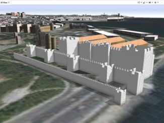
Your International Geospatial Briefing for June 22nd: Google Maps Platform; Global Partnership on Artificial Intelligence; Geospatial Data Strengthens Electrical Grids; Entire Roman City Mapped Using GPR

22 June 2020 GoGeomatics Canada | AI

Google Maps Platform gaming solution now available to everyone Google first launched a gaming solution to bring real-world games to life with a limited group of studios two years ago. From this, 10 games have […]

|||||
Technology

Applications of 3D Digital Twins for Heritage and Archaeological Sites

22 June 2020 Alan D.K. Armstrong | 3D Mapping

Digital Twins have many applications outside of the more well-known ones in the Internet of Things and Artificial Intelligence – including valuable applications for historic and archeological sites A digital twin. What is it exactly? […]

||
Technology

Advances in Satellite Imagery and Technology Cause a Basemap Evolution

21 June 2020 Maxar | basemaps

Digital mapping as a discipline emerged in the 1960s, when the U.S. Census Bureau used geographic information systems (GIS) and digital cartography to fully understand and visualize population trends. Since then, the abilities of geospatial […]

||
Technology

COVID-19: Supporting Kamloops, BC businesses using Story Maps

18 June 2020 Saeideh Hejazi | ArcGIS Online

In the middle of March 2020, COVID-19 pandemic leads to social distancing rules in Canada. Public areas such as restaurants are closed. Some restaurants in Kamloops city in British Columbia have been working through takeout […]

Between the Poles – The Geoff Zeiss Archives

Digitally capturing the location of underground utilities detected using electromagnetic techniques

16 June 2020 Geoff Zeiss

The industry standard for locating underground utilities is a manual process involving the use of an electromagnetic (EM) wand to detect underground cables and pipes.  The detected location is typically recorded by painting or otherwise […]

lindsey goncalves|
Community

Introducing Lindsey, Saeideh, & Paul: New GoGeomatics Online Community Managers

16 June 2020 Jon Murphy | Canada

We are pleased to welcome three new members to our team as online community mangers. Please say hello and connect with Lindsey, Saeideh and Paul. The three of them join us from around the country […]

||||
Newsmakers & Press Releases

GeoIgnite: Leadership in Times of Disruption

16 June 2020 GoGeomatics Canada | Agriculture Canada

Join us virtually this year for Canada’s National Geospatial Leadership: GeoIgnite conference on July 22nd to 24th, 2020! This event will showcase Canadian geospatial community and leaders of Canada’s location technology sector. Join us for talks, […]

Between the Poles – The Geoff Zeiss Archives

Survey delineates subsurface utility engineering (SUE) adoption in Canada

15 June 2020 Geoff Zeiss

The Centre for Advancement of Trenchless Technologies(CATT) has just released the report of a survey designed to better understand the current state of subsurface utility engineering (SUE) practices, barriers, and acceptance across Canada.  The most […]

Posts pagination

« 1 2 3 4 »

Events

Apr 15
6:30 am - 8:30 pm

GoGeomatics Vancouver Meetup – April Networking Social

Apr 21
6:00 pm - 8:00 pm

Calgary GoGeomatics April Social

Apr 22
April 22 - April 23

11th Annual Digitalization & AI in Energy Canada Conference

Apr 27
April 27 - April 30

Welcome to the Canadian Hydrographic Conference 2026

May 3
May 3 @ 8:00 am - May 6 @ 5:00 pm

GEOINT Symposium 2026

View Calendar

View All Events

Services

  • Post a Job
  • Post an Ad
  • Post an Event
  • Post a Directory Listing
  • Post a Press Release
  • Media Kit
  • My Account
  • Login

Jobs

Post a Job
  • GIS Technologist II
    Fernie, B.C.
  • GIS I TECHNOLOGIST
    Fernie, B.C.
  • Building Science and Restoration CAD/BIM Technologist
    Vancouver
  • Digital Services Coordinator (BIM)
    Toronto
View All Jobs
  • Directories
    • Associations Directory
    • Industry Directory
    • Education Programs
    • Open Data
  • Volunteer
    • Start a GoGeomatics Group
    • Editors & Writers Group
  • About Us
    • GoGeomatics Media Kit
    • Who We Are
    • Contact Us
    • FAQ’s
    • Advertising
    • Marketing
  • Subscribe
GoGeomatics
GoGeomatics is the largest and most popular communications hub promoting the Canadian geospatial community. The business was incorporated in 2011. GoGeomatics hosts over 100 fun, free, location technology networking events each year in cities across Canada.

© 2026 GoGeomatics

  • facebook
  • Twitter
  • Linkedin
  • Youtube
  • Linkedin Group