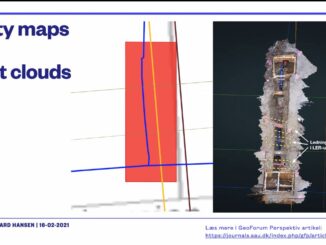
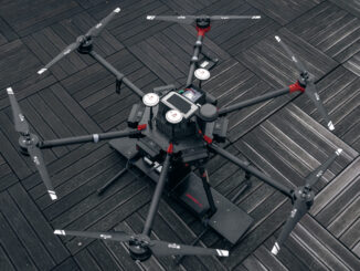
• facebook
  • Twitter
  • Linkedin
  • Youtube
  • Linkedin Group
  • Post a Job
  • Post an Ad
  • Post an Event
  • Post a Directory Listing
  • Post a Press Release
  • Media Kit
  • My Account
  • Login
GoGeomatics
  • MAGAZINE
    • BIM & GIS
    • Community
    • Conference news
    • Earth Observation
    • Education & Careers
    • GEOAI
    • Announcements
    • Reality Capture & Lidar
    • Science
    • Technology
  • Directories
    • ASSOCIATION
    • INDUSTRY
    • EDUCATION
    • Open Data
  • EVENTS
    • GeoIgnite Events
    • Events Calendar
    • GoGeomatics Meetups
  • Services
    • Advertising
    • Marketing
    • Post a Job
    • Post an Ad
    • Post an Event
    • Post a Press Release
    • Post a Directory Listing
    • Media Kit
    • Web Design
  • Find a Job
  • Volunteer
    • Start a GoGeomatics Group
    • Editors & Writers Group
  • About Us
    • About Us
    • Contact Us
    • Frequently Asked Questions
  • Videos
Home2021

Year: 2021

Newsmakers & Press Releases

MDA Platinum Sponsor of Canada’s National Geospatial Event: GeoIgnite 2021

12 January 2021 GoGeomatics Canada | April 2021

Canadian Leadership & Geospatial Intelligence  GeoIgnite invites the geospatial community to engage with one another by sharing your work, services, and data at our third annual conference.  Download the sector participation package PDF. One month […]

|||||
Technology

Your International Geospatial Briefing for January 11th : EA images major 2020 events; Maps are the future of smart cities & AV; Airbus-built CSO-2 French military Earth Observation satellite launched successfully; 2021 predictions for the drone industry; Indian Armed Forces ‘Reject’ Defense Ministry’s plan to ease norms On Geospatial Mapping.

11 January 2021 GoGeomatics Canada | 2020 in pictures

Satellite images capture major events of 2020. The pandemic brought the world to a grinding halt in 2020, however that did not stop satellites from orbiting the Earth. In this article, notable events that shaped […]

||||||
Technology

The top 6 Satellite Remote Sensing Software tools

11 January 2021 Celso Isidro | Air Bus Space Agency

Nowadays, satellite remote sensing comes in handy and can now be employed in our day-to-day activities. This technology, with the assistance of GPS and GIS, provides tools and analysis relevant to real-time road mapping and […]

|||||
Technology

What are Statistics Canada’s geographic terms: CT, CSD, CMA and more

8 January 2021 Saeideh Hejazi | 2016 census of population

Geographic data are applied in any location-based projects. We all might hear a lot about geographic terms but when we want to work directly with them, we should know the detailed definition of them. For […]

Posts pagination

« 1 … 28 29

Events

Notice
There are no upcoming events.

View All Events

Services

  • Post a Job
  • Post an Ad
  • Post an Event
  • Post a Directory Listing
  • Post a Press Release
  • Media Kit
  • My Account
  • Login

Jobs

Post a Job
  • Canada Maps and Poster Gallery Volunteer Leads — GeoIgnite 2026
    remote
  • GIS & Data Analytics Lead
    Beaumont, AB
  • Lead Surveyor, Projects/Arpenteur-géomètre principal, projets; arpenteuse-géomètre principale, projets
    North Bay, Thunder Bay
  • Senior GIS Developer
    Calgary, AB
View All Jobs
  • Directories
    • Associations Directory
    • Industry Directory
    • Education Programs
    • Open Data
  • Volunteer
    • Start a GoGeomatics Group
    • Editors & Writers Group
  • About Us
    • GoGeomatics Media Kit
    • Who We Are
    • Contact Us
    • FAQ’s
    • Advertising
    • Marketing
  • Subscribe
GoGeomatics
GoGeomatics is the largest and most popular communications hub promoting the Canadian geospatial community. The business was incorporated in 2011. GoGeomatics hosts over 100 fun, free, location technology networking events each year in cities across Canada.

© 2025 GoGeomatics

  • facebook
  • Twitter
  • Linkedin
  • Youtube
  • Linkedin Group