• facebook
  • Twitter
  • Linkedin
  • Youtube
  • Linkedin Group
  • Post a Job
  • Post an Ad
  • Post an Event
  • Post a Directory Listing
  • Post a Press Release
  • Media Kit
  • My Account
  • Login
GoGeomatics
  • MAGAZINE
    • BIM & GIS
    • Community
    • Conference news
    • Earth Observation
    • Education & Careers
    • GEOAI
    • Announcements
    • Reality Capture & Lidar
    • Science
    • Technology
    • Between the Poles
  • Directories
    • ASSOCIATION
    • INDUSTRY
    • EDUCATION
    • Open Data
  • EVENTS
    • GeoIgnite Events
    • Events Calendar
    • GoGeomatics Meetups
  • Services
    • Advertising
    • Marketing
    • Post a Job
    • Post an Ad
    • Post an Event
    • Post a Press Release
    • Post a Directory Listing
    • Media Kit
    • Web Design
  • Find a Job
  • Volunteer
    • Start a GoGeomatics Group
    • Editors & Writers Group
  • About Us
    • About Us
    • Contact Us
    • Frequently Asked Questions
  • Videos
Home2021

Year: 2021

||||||||||
Technology

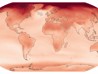
New interactive atlas paints a picture of how climate change will impact the globe and what this means for Canada

22 October 2021 Crystal Fitzpatrick | Canada

The latest Intergovernmental Panel on Climate Change (IPCC) sixth assessment report warns about the future of our planet under the impacts of climate change. Following the findings from the last report, measured in 2011, this […]

No Picture
Community

Capitalize On Our New Technical/Marketing Content Writing Service

22 October 2021 Ozair Khan

Let’s admit it. Geospatial techs are brilliant. They help develop smart technology that solves problems our industry faces conveniently, quickly, and affordably. There are so many Canadian geospatial start-ups, growing tech companies, and some mature […]

Between the Poles – The Geoff Zeiss Archives

Grid resilience demands we understand our infrastructure above and below ground

21 October 2021 Geoff Zeiss

Jay Cadman, SVP Enterprise, IQGeo As the glue interlinking everything from the industrial ‘Internet of Things’ to smart grids and underpinning the real-time social and economic services of the future, full fiber and 5G is […]

|||
Technology

NV5 Geospatial Supports Flood Risk Mapping in Montreal Through Canada’s Largest Riverine Topobathymetric Lidar Survey

20 October 2021 Sven Cowan | Canada

The Greater Montréal Area completed Canada’s largest-ever riverine topobathymetric lidar survey inresponse to two major flooding events within the last five years, which together displaced tens ofthousands from their homes and cost millions to local […]

||||||
Technology

Geospatial Canada Briefing Oct 19: 1. Tsunami mapping; 2. Re-forestation with drones; 3. Vinland Map; 4. Holographic Sonar Displays; 5. Flood mapping; 6. drones in search & rescue

18 October 2021 GoGeomatics Canada | drones

Tsunami mapping provides clearer picture of devastation for NW Vancouver Island A $1.2 million collaboration between five First Nations, four municipalities, two Regional Districts, and several private stakeholders have produced Phase 1 of a comprehensive […]

|
Technology

World’s First Holographic Tactical Display for Detecting Submarines, by Canadian Technology Companies

18 October 2021 Zarin Mom | 3D

About Kongsberg Geospatial: Based in Ottawa, Canada, Kongsberg Geospatial creates precision real-time software for mapping, geospatial visualization, and situational awareness. The Company’s products are primarily deployed in solutions for air-traffic control, Command and Control, and air defense.   About […]

Newsmakers & Press Releases

Two Great Sessions / Présentation de deux grandes sessions ‘A Roadmap for Data Across Canada’ & ‘Data Liberation Matters’

17 October 2021 GoGeomatics Newsmakers | bilingual

Register Today! Presenting Two Great Sessions from the Canadian Open Data Summit:‘A Roadmap for Data Across Canada’ and ‘Data Liberation Matters’(Français ci-dessous)The Society’s learning opportunity this month includes a pair of sessions from the Canadian […]

wGIC|
Newsmakers & Press Releases

Spatial Digital Twins Research Project Initiated by WGIC

15 October 2021 GoGeomatics Newsmakers | geospatial industry

Spatial Digital Twins Research Project Initiated by WGIC […]

Posts pagination

« 1 … 7 8 9 … 36 »

Events

Notice
There are no upcoming events.

View All Events

Services

  • Post a Job
  • Post an Ad
  • Post an Event
  • Post a Directory Listing
  • Post a Press Release
  • Media Kit
  • My Account
  • Login

Jobs

Post a Job
  • Volunteer Editorial Contributor – Be Part of Canada’s Geomatics Story
    Remote
  • Junior Geomatics Field Technician – Technical Surveys
    Montréal, QC
  • GIS Specialist
    Amherst, Nova Scotia
  • Precast Structural BIM Specialist
    Calgary, Alberta
View All Jobs
  • Directories
    • Associations Directory
    • Industry Directory
    • Education Programs
    • Open Data
  • Volunteer
    • Start a GoGeomatics Group
    • Editors & Writers Group
  • About Us
    • GoGeomatics Media Kit
    • Who We Are
    • Contact Us
    • FAQ’s
    • Advertising
    • Marketing
  • Subscribe
GoGeomatics
GoGeomatics is the largest and most popular communications hub promoting the Canadian geospatial community. The business was incorporated in 2011. GoGeomatics hosts over 100 fun, free, location technology networking events each year in cities across Canada.

© 2026 GoGeomatics

  • facebook
  • Twitter
  • Linkedin
  • Youtube
  • Linkedin Group