Ready Surveyor One!
Surveying is not a game. However, a game-like virtual environment could be a valuable tool for training, site safety, planning, project management, and more.
I do not think I am alone in feeling a little burnt out and let down by all of the recent hype about “metaverses”. So much talk, with so few examples of real-world applications. For all of the potential uses for engineering, surveying, construction, digital twins, asset and infrastructure management, we’re still waiting for a “usefulverse”.
After all, several generations have grown up immersed in virtual environments: mostly in increasingly sophisticated games. 3D is de rigueur; essential in AEC and how we capture reality data. There are great examples of the application of mixed reality, for example, for field design investigations and construction stakeout.
What could surveyors do with an immersive and interactive virtual environment? Training immediately comes to mind. In some regions, survey firms are struggling to keep up with peak demand for their services, and they are adding new staff with different levels of experience. Even if you hire an experienced field surveyor, they might have previously been using different instruments and software. A virtual training environment enables them to get familiar with your firm’s gear, types of field tasks you’ll assign them, and your best practices.

In this quest, “Bob” the survey avatar is tasked with taking topo shots with the GNSS rover, with the SX12 and prism, and initiating a scan of the house. On the left is the TVW app view, and on the right is Trimble Access (in this instance as an emulator). In Access (and the inset view in TVW) you see what the camera in the SX12 sees. You do the rectangular scan area selection in Access. While the virtual scan is running, Bob can take shots with the rover. Note the swirling blue beam in the distance. This is a highlight placed in the quest to guide you to the next task.
Of course, technology will never be able to replace hands-on, mentor taught professional aspects of surveying. No one has ever said it could, but there are aspects where it could be a big help. After all, commercial and military pilots put in a lot of hours in a flight simulator.
TVW
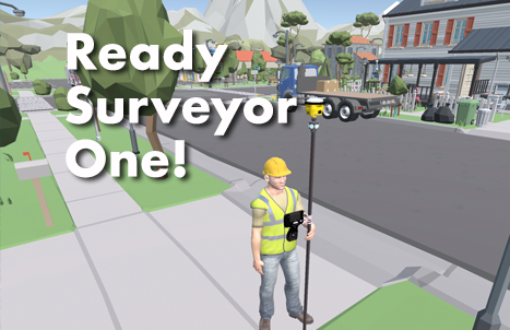
I have grown less cynical about the prospects for virtualization for surveying since taking Trimble Virtual World (TVW) for a spin. I was pleasantly surprised how sophisticated it is, yet fairly simple to navigate. While still in beta (for perhaps another year) , folks who signed up for the early experience program (EEP), have already create many “quests”, walking a trainee through many tasks, using a variety of gear in familiar jobsite environments. It does look like a game; and I find that one of its strengths. And you have the option of connecting to your own data controller (e.g., TSC7 or T100) or using an emulator (more on that later). This article is not a “how to” guide. There are plenty of resources to learn the process, however, I noted a few steps to show how it all works.

In this example, you guide the avatar in operating a total station from the rod to measure, then create a 3D stockpile model in Access.
Setup
Once you’ve signed up (contact your local distributor who will make the request for onboarding), you first download and install TVW through Trimble Installation Manager (TIM, online or offline). You log in with the same Trimble ID as you use to manage your equipment, licenses, support, community forums, etc.
You can connect your own data controller (DC) to TVW or download and install a Trimble Access (or SiteWorks for construction) emulator via TIM. Provided that your DC and PC are connected to the same internet source (e.g., WiFi hotspot), you can set the ports in Access on your DC to match defaults in TVW; different I.P. addresses and ports for different instruments, like GNSS rovers and total stations. Both options are outlined in one of many helpful TVW training videos. For example: a helpful overview of the latest version of TVW, a multi-part tutorial on doing a traverse in TVW, and how to build a “quest”.
I should back up a little… I would highly recommend watching the TVW videos before getting started. I always like to try new things cold turkey, to see how intuitive the workflow is, however, in this case I could have saved a lot of time stumbling around if I’d read and viewed the materials beforehand. That’s not to say that working in TVW is complicated; quite the contrary. A trainee using a quest that you have designed will be able to follow along quite well (which is a goal for effective training materials). The complexity is in the initial setup, and in authoring the training “quests” (a game-like term, that fits quite well).

Another quest, set at a dam site. TVW on the left and Access on the right.
Guillaume Clin, product manager for TVW, is one of the whiz kids that put this toolset together. He walked me through the basics, and recommended I use a data controller: “ It gives a more realistic and immersive experience of what the user will do in the field”. However, I also found the emulator to be useful with a split screen: TVW on one side, and Access on the other. There are certain tasks that you do only in TVW: setup, site navigation, tool selection, etc. Guillaume pointed out that you need to switch from controller (or emulator) to TVW to execute different steps the workflow. TVW does not control Access, you do any observations and surveying tasks in Access, with the instruments and accessories you pick in TVW for a given task. When to switch between TVW and Access became second nature shortly after starting one of the training quests.
Before you try navigating and moving the avatar around in TVW, go to the main menu, choose settings, and pick the control tab (note there are ‘run’ and ‘edit’ modes. This gives you a handy guide for keyboard navigation. Of course, you also have the option of connecting a game controller, for instance, an Xbox game controller paired with your PC. Note that this is only for TVW navigation; you operated the DC (Access or SiteWorks) through said DC (or emulator).
Worlds and Quests
Once in TVW, you will see a lot of canned “worlds”. Generic ones for 3D terrain, a cityscape, and a construction site, with new ones being added for specialized applications, like mines, tunnels, construction MEP, etc. The default surveyor avatars (can I coin the term “surveyatar”?) include “Bob” in the yellow vest, and “Stu” (the grizzled one) in the Poly Construction space, who has an orange vest.

“Stu”, one of the surveyor avatars in a virtual construction space. This is the view in the TVW application, with controls, with instrument status, position, and tools selected. In this scenario, a GNSS rover and total station have bene chosen to set conduction stakes. A physical data controller (or emulator) is connected to control the instruments and collect virtual data, perform stakeout, intimate scans, etc.
For example, with the Access emulator also running, in TVW I chose “Polygon Town”. By clicking on the lower right, it brings up a circular menu. I picked markers, and a peg (stake), then ‘Pole’ and ‘GPS’, then the ‘R10’. Note: they should change that to GNSS and R12i. 😉 The hardhat and vest wearing avatar is now holding a rod with a GNSS rover. Now to take a shot and set the peg…
Then, switching over to the Access window (with a dummy job open), picking ‘Measure’ and ‘RTK’, it prompts me to accept an emulated base station. Then survey starts. I see the e-bubble is good, and the familiar options for point name, code, antenna height, method (e.g., observed control point), etc. Then hit ‘measure’.
The team that developed this cleverly set it up to emulate a GNSS/RTK measurement at the virtual location. You can see the predicted precisions; even open up a sky plot. With the observation stored, it adds a point and sets a peg in the TVW view. By switching to a scanning total station (e.g., SX12), and prism on the rod, shots can be taken in Access, and the instrument can even be tasked with doing a full or partial scan of part of the 3D model in TVW. You even get to see an emulation of that scan. If your TS has vision enabled, you can see an emulation of what it would see, have it search for the prism, etc. For the most part, this all works pretty much the same way you would operate a physical instrument, but keep in mind, TVW is still in beta, and it took a bit of fumbling and bumbling to get things to work.
Building a quest takes quite a bit more work. Again, there are videos to help. I thought about a scenario for a new crew member, a typical site topo job: They’d need to set two or more control points, do TS setups on one or more of these, resect for part of the site, take some topo shots, and then do partial scans of some of the structures on the site. To help guide the trainee through the steps, you can create a narrative, and place “highlights” where, for instance, they need to set control of do instrument setups. The “highlights” look like a swirling shaft of light, like a sci-fi transporter.

The quest buildier interface. In this example, a model of a rail station was imported from SketchUp 3D Warehouse, with tools and tasks added from the menus. In addition to the massive selection of objects in the 3D Warehouse, you will be able to import (compatible format) 3D models from real-world sites and designs.
You can make any number of quests; copy and edit them as needed. I’d like to see a library of shared quests.
Site Specific
You could potentially be very site specific in developing a virtual world and quests. Even now, you can import 3D models. For instance, in one quest I saw a 3D digital twin of Wellington New Zealand. And you can add 3D objects from the SketchUp 3D Warehouse in categories like landscapes, buildings, transportation, etc. I even found a Tardis in there.
I’m still working on this, but part of my own city has been digital twinned, and I thought it would be primo for my crews to be able to work in that real-world mirror, with imported local control, etc. Guillaume informed me that registration tools are being refined, and I should be able to do this in the very near future.
Next
By being able to leverage digital twins, and 3D models of real-world construction sites and other infrastructure, is where I believe that TVW has so much potential beyond just instrument training. Already, TVW is a great start, and it should be quite valuable for training as is.

Plus, this can be a lot of fun. Somone created this quest of an intrepid Rebel Alliance surveyor measuring these spacecraft with reflectorless total station shots and a scan. I wonder what the field data collector code list for this would be like?
Ok, it is a little rough around the edges right now; there are a few kinks to iron out. And if I might suggest, a bit more work on the user experience. Many of the potential users of this amazing tool are not quite as familiar with or comfortable (yet) in such environments\ as the developers. Especially for example, how this tool handles interactions between the application and the DC/emulator. However, by the time it gets out of beta, I’m confident it will be quite slick.
What could be next? With all of the successful development of mixed reality tools (e.g., XR10 and SiteVision), and virtual reality tools like TVW, could some cross-pollination be in the cards? How 3D data is captured is evolving, how as-built surveys are done, how sites are monitored, and so much more. And, whether folks like the idea or not, we are going to be working alongside a lot more robots and other forms of automation. Virtualization, mixed reality, and digitalization go hand in hand.
The whiz kids that put TVW together have succeeded in creating a fully functioning, immersive, interactive educational “game” (for lack of better term), that you can tailor to your needs. So, game on!


