Past, Present, and Potential Future of Surveying
Field surveying is the trade behind many construction and engineering projects globally. From buildings, to railways, and resource based industries, the trade is widely used across many professions as a starting and ending point for large-scale projects. Field surveying can be considered one of the oldest organized trades in history. With standardized mathematics using trigonometry, the practice has been dated to millennia of use.
Examples of uses through the years include building large structures, establishing property boundaries, and mapping geomorphology processes. Surveying today is still used for the same purposes and utilizes modern technologies to make projects easier, more efficient, and eliminate any potential errors. This article aims to focus on how surveying has evolved and what the future of the trade may look like. To start, let’s look more closely at how historical tactics and technologies were used, and how they have evolved into the modern uses seen commonly today.
Brief History of surveying (math, technology)
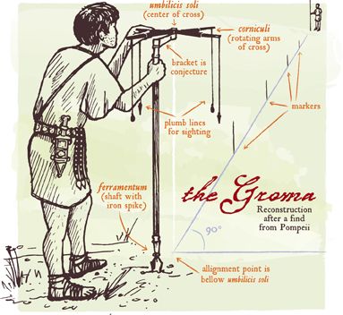
Some of the earliest surveying equipment involved nothing more than string and a rock (Lyman, John, and Wright, John Wilfrid). Dating back to evidence from ancient Egypt and Greece, simple equipment and mathematics were utilized to make most of the great structures in these regions. By creating a plum bob, a vertical surface line can be established, and from there, the rest comes down to mathematics application.
As time progressed, the mathematics associated with surveying advanced alongside equipment. These advancements, in turn, led to some of the earliest total stations, allowing for a boom in surveying that brought higher accuracy to the existing knowledge behind trained professionals.
(https://www.arcsurveys.ca/land-surveying-is-ancient-history Historical surveying equipment)

The Groma, Ancient Roman Surveying Tool. Source: https://www.arcsurveys.ca/land-surveying-is-ancient-history
Modern equipment has come a long way from its foundations. Satellite imagery, centimeter-level accuracy from GPS equipment, and drones fitted with Lidar and other spectral cameras all contribute to making geomatics and surveying a far more efficient and technology-utilized environment. This was not an overnight change as many iterations of the modern equipment have gone through some clunky versions. Knowing of the modern transition, we can now look at how future tactics will transition the industry.
Future set of Tactics: Augmented Reality, High precision LiDAR & Drones
Some future tactics are much closer to reality. UAV-based mapping, augmented reality, and other advances in GIS and Remote Sensing have been evolving the industry toward more efficient and less error-prone resources. Here are some case studies for some advancements that are currently being utilized in both forestry and construction surveying.
High-precision UAV-Lidar Mapping has made it possible to analyze particular features, such as power lines and tree canopies, to a very high accuracy rate. This allows for higher standards of data and higher standard of project deliverables. The tool itself is a flight planned drone with geo-referenced software to aid in data acquisition without the need to process the data off site (GIM International).

GIM International – Lidar Forest Area. Source: https://www.gim-international.com/content/news/elevating-high-precision-uav-lidar-mapping-2
This particular tool has a great benefit to field operations, and would be a great efficiency production tool for many construction companies and contractors.
Another example is Trimble’s Artificial Reality and Virtual Reality hardware and software that has recently been distributed. The examples provided show how civil construction can be aided by these tools. The AR and VR ability to see the progress of how construction projects can help keep projects on time and on budget without the need for costly corrections that may occur from human or environmental error (Trimble).

Trimble – Visualize in 3D. Source: https://sitevision.trimble.com/
Impact on surveying world: Field, Construction, Municipal
As part of the discussion portion of this article, sharing the potential future of where surveying will go and what may change and what will still stay the same. We’ll take everything previously discussed to make inferences.
The field component may see advances for efficiency, but the necessity needed for boots on the ground workers to confirm lidar and other satellite based imagery is still needed. Inaccuracies can occur due to seasonal changes, such as canopy changes and snow, and creates difficulty in identifying features such as constructed roads. Field experience in remote locations has tremendous value, and the knowledge can cover far more than what is currently available. But, utilizing drones for projects to capture clear and localized imagery far exceeds data requests from high end satellites, making it possible for smaller companies to have industry standard deliverables at a reasonable cost.
Civil work however, is being quite streamlined. With all the advances previously talked about, especially with Trimble’s AR and VR advances, civil projects can be done at greater efficiencies by being able to track progress in real time with the ability to catch errors sooner and adjust accordingly.
This opens the floor for what may happen moving forward. As imagery gets more and more precise, we’ll be able to identify individual trees or have resolution capable of finding objects at scales that are currently unthinkable.
What niche areas do you think geospatial technology will improve in to promote efficiencies?
As well, will remote field work ever be replaceable because of those advancements?


