Canadian Geospatial RPAS Advances at GoGeomatics Expo
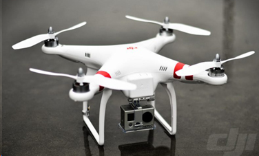
Just over a decade ago, the DJI phantom 1 was released which only had a GoPro Camera. A few years later, the DJI phantom 3 hit the markets. Coupled with PIX4D and various other photogrammetric software, the geospatial industry was revolutionized, and the possibilities were unlimited. However, industry wasn’t satisfied. Very quickly, Transport Canada released new licensing for RPAS pilots, larger RPAS came onto the market, LiDAR technology was miniaturized and the rise of low weight, high resolution integrated LiDAR and photogrammetric sensors have changed the geospatial data acquisition scene.
Figure 1: DJI Phantom 1
Considering this exponential growth of the industry, questions such as how much growth is left or what level maturity do we want RPAS technology to be at or how are other members of industry using them are always at the forefront of evolving technology. With a specific Canadian flare, this year’s GoGeomatics RPAS program will bring together leading companies and professionals to showcase, discuss and explore new technology that has been realeased, being worked on, novel use cases and supporting equipment.
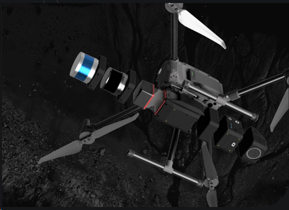
Each of our 3 specially curated talks aim to shed some light on these questions. Firstly, one of Canada’s leading LiDAR experts Dr Tim Webster of AGRG of NSCC will do a comparison of L1 and L2 sensors while exploring the multiple use cases. Secondly, Operations Lead Graham Anderson of Spexi Geospatial will showcase how going small doesn’t mean going home. Spexi has democratized the geospatial imagery data collection scene though the use of small RPAS. Lastly, Johnathan Smeh of Balko Tech will present their ongoing development of a modular RPAS remote sensing eco-system.
Figure 2: Balko Tech’s Modular System on DJI M300
Lastly, our panel manned by experts from both academic (SAIT) and commercial (Balko Tech) sensor development coupled with end users (Lone Drone Solutions) discusses how far RPAS sensors have come since the Phantom 1. We look to explore questions such as what drives development, what quality of data is expected out of these sensors, how are they used and many more. In addition, we will try to shed some light on future trends that sensor technology is gravitating towards to.
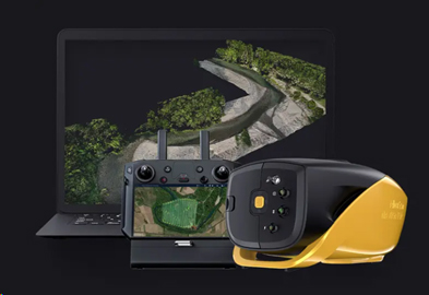
Figure 3: YellowScan Navigator, Integrated Bathymetric RPAS sensor
On October 29 and 30 join us in Calgary with exhibitors such as PIX4D, Balko Tech, Riegl, Spatial Technologies, Measur and TopoDot to explore and discuss developing trends and technologies with leading passionate Canadian RPAS professionals.


