


Canadian Geospatial Digest for February 17, 2025
- Canada Allocates $72 Million for Satellite Network to Track Wildfires
- New Website Maps the Origins and Movement of Canada’s Fruits and Vegetables
- B.C. Collaboration Develops Digital Database of Mine Tailings and Critical Minerals
- Growing Space Debris: Could Falling Junk Pose a Risk to Aircraft?
- Wyvern Releases Free Access to Hyperspectral Earth Observation Data
- Interactive Map Showcases NWT’s Energy-Saving Initiatives
Canada Allocates $72 Million for Satellite Network to Track Wildfires
exactEarth Ltd., a subsidiary of Spire Global Canada, has been awarded a $72 million contract to design the WildFireSat constellation, following its acquisition of exactEarth Ltd. The project will deploy seven microsatellites to monitor active wildfires across Canada daily, providing critical data for fire management and air quality forecasts. This information will help authorities track fire behavior, identify high-risk areas, and improve protection for Canadians, particularly in remote and northern regions.
Read more here
New Website Maps the Origins and Movement of Canada’s Fruits and Vegetables
The University of British Columbia has launched Canada Food Flows, an interactive website mapping the movement of 34 popular fruits and vegetables into and across Canadian provinces over 13 years. This tool reveals the extensive interconnections between international and inter-provincial food systems. On average, about 50 per cent of vegetables (excluding potatoes) and 75 per cent of fruits consumed in Canada are imported, primarily from the U.S. The platform aims to help Canadians understand the origins of their produce and to encourage discussions on how factors like climate change and trade policies could affect future supply.
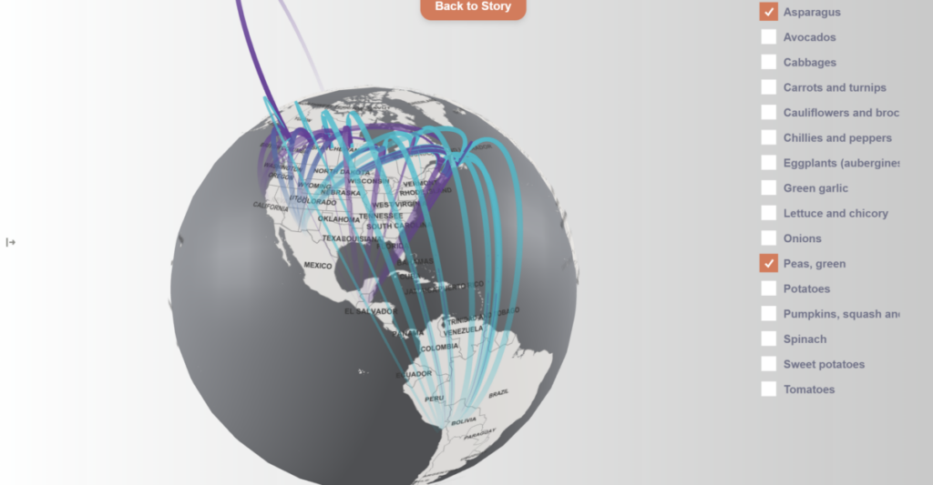
Screenshot from Canada Food Flows website – Source: Canada Food Flows
Read more here
B.C. Collaboration Develops Digital Database of Mine Tailings and Critical Minerals
Geoscience BC has developed a digital database mapping mine tailings and waste rock sites across British Columbia to support critical mineral development. Created with partners like Foresight Canada and New Gold, the resource compiles data from over 1,000 sites linked to 500+ mining operations. The initiative aims to help industry, government, and Indigenous groups assess the potential for re-mining valuable materials from past mining activities.

Screenshot from Contacts for First Nation Consultation Areas Public Map – Source: Government of British Columbia
Read more here
Growing Space Debris: Could Falling Junk Pose a Risk to Aircraft?
The increasing volume of space debris poses a growing threat to aviation safety. As more satellites and rockets are launched, the likelihood of uncontrolled reentries into Earth’s atmosphere rises, potentially endangering aircraft. While the probability of such collisions remains low, the potential consequences could be catastrophic. Experts suggest implementing measures such as controlled reentries and improved tracking systems to mitigate these risks.
Read more here
Wyvern Releases Free Access to Hyperspectral Earth Observation Data
In February 2025, Canadian space data company Wyvern launched an Open Data Program to provide free access to hyperspectral satellite imagery. The program offers an initial set of 25 images featuring diverse global land cover types, including forests, fires, crop fields, coastal areas, mines, and solar farms. These images are available under the CC BY 4.0 Creative Commons license, allowing unrestricted use with proper attribution to Wyvern. The initiative aims to foster innovation in the remote sensing community and demonstrate the potential of hyperspectral imagery in addressing global challenges. Wyvern plans to expand the program as its Dragonette satellite constellation captures more data, with the fourth satellite’s launch scheduled for the first half of 2025.

A Wyvern Dragonette satellite image of a location in Iraq. – Source: Spatial Source
Read more here
Interactive Map Showcases NWT’s Energy-Saving Initiatives
The Arctic Energy Alliance has introduced an interactive map detailing the impact of energy efficiency projects across Northwest Territories communities. This tool highlights reductions in energy consumption and emissions resulting from initiatives like wood stove installations and home retrofits. The map aims to assist organizations and local governments in energy planning and showcases the collective benefits of community-led efforts in combating climate change.

Screenshot from Energy-Savings Project Map – Source: Arctic Energy Alliance
Read more here