
Augmented Reality brings benefits and technical challenges to the world of utility mapping.
Michael Bundock, CEO and Founder of Augview Ltd, engaged participants when he spoke during a livestream presentation on March 23, 2022, at SUMSF. He expertly discussed the topic of benefits and technology of augmented reality (AR) in subsurface utility mapping.

Bundock discussed how AR benefits subsurface utility mapping, what AR means, AR use cases for SUM, and technical challenges.
Using AR can show the appropriate physical characteristics, as well as dynamic characteristics of utilities. For example, AR sensors can show the diameter, pressures, temperatures, and wind speed. This data can be shown in virtual gauges, graphs, colours, and dynamic models. You can see what is happening in real-time.
Benefits of using AR include being able to see hidden features and characteristics, stimulation to the brain, and no need for mental mapping. The device knows where we are physically and oriented in the real world.
There are challenges. User data needs include access to federated databases, requiring high-speed data from multiple sources, optics, sensors, surface tracking, and user interaction.
AR glasses need to have a wide field of view (90 degrees), high resolution, binocular depth perception, eye tracking and be usable during day or night (bright sun and darkness). The glasses also need to be immersive and believable.
Many prototypes of useful devices are available and work well, but more development is needed to make the devices more adapted to a targeted audience and types of work.
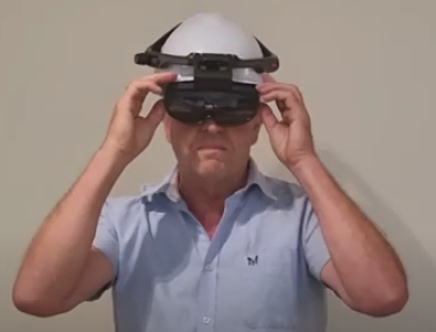
Bundock showed an example of a useful device, the Rokid X-Craft. Among its many features, it has finger tracking, voice recognition, rail-mounted controls, 45-degree view, Android, 4G/5G, SLAM, GNSS, an eight-hour battery and is ruggedized.
A deep, heartfelt thank you to Augview Ltd., a Silver Sponsor for SUMSF, 2022 (The Subsurface Utility Mapping Strategy Forum).
An interesting Q and A session followed the presentation. You can watch the live-streamed presentation on Youtube below.


Be the first to comment