Andy Dean

Dr. Andy Dean has more than 15 years of experience helping companies and organizations improve their environmental programs with geographic information systems, remote sensing, and environmental information systems. As a specialist in geomatics and remote sensing, he has worked in the mining, energy, climate change, water resources, and biodiversity conservation sectors to harness the benefits of these technologies for improved management decisions. As well, Andy has experience managing projects in North America, Europe, Africa, and Asia. He served as vice-president of PT Hatfield Indonesia from 2008 to 2011. He is Director of Hatfield’s Geomatics Group and Director of Calgary Operations.

Articles by Andy Dean

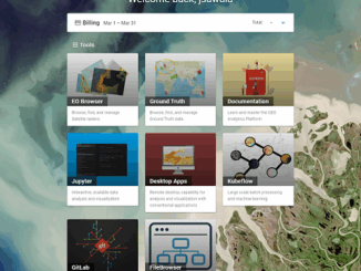
GEOAnalytics.ca – A demonstration cloud-native open platform for Big Data geoscience

Current data-driven and computing intensive research on climate-change, ecosystem modeling, and environmental and natural resources monitoring is based on the…

User Needs Assessment for the Canadian Geospatial Data Infrastructure published by Natural Resources Canada

User Needs Assessment for the Canadian Geospatial Data Infrastructure published by Natural Resources Canada – HATFIELD CONSULTANTS PARTNERSHIP Hatfield led…

Hatfield releases R-BAM algorithm to all Canadian wildfire agencies

The Rapid Burned Area Mapping (R-BAM) technology was developed over the last three years by Hatfield Consultants and aims to…

Findings Released from European Space Agency Earth Observation for Oil and Gas Project

Over the past 20 years, oil and gas companies have used satellite earth observation technology through the entire project lifecycle,…