Brent Wanless

Brent Wanless has over 30 years of experience in Geomatics engineering, mapping, and remote sensing fields. His national and international work experience encompasses both project management and business support. Brent has provided consulting expertise in marketing, management, development, and field operations of GPS, Lidar, digital imaging, and integrated remote sensing systems.

Brent Wanless holds both a Master of Science in Geomatics Engineering (NSERC Scholarship) and a Bachelor of Science in Survey Engineering (Gold Medal Award, Deans List) from the University of Calgary (Alberta, Canada). He is a Professional Engineer registered with the Association of Professional Engineers, Geologists and Geophysicists of Alberta (APEGA).

Articles by Brent Wanless

UAV Mapping

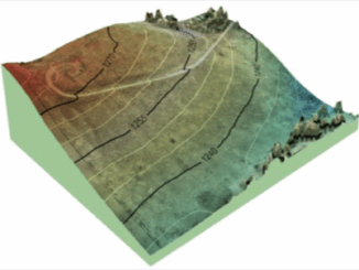
Canadian UAV Company Maps Forest Fire Damage in Alberta

Industry and public awareness for commercial applications of UAV technology has increased significantly in Canada and throughout North America. Initially…