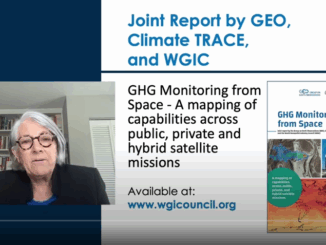
GoGeomatics Canada

GoGeomatics Canada’s Online Magazine is your source for the latest news in the Canadian geomatics sector. We publish articles about technology, projects, events, Canadian companies, and interviews with industry leaders. To submit an article to the GoGeomatics Magazine, please email your pitch to [email protected].
|||
Technology

Canadian Geospatial Briefing April 18th: 1. Esri Canada program director’s sudden passing; 2. Kanien’kéha mapping project; 3. Indigenous People’s Atlas of Canada; 4. Vernon floodplain maps; 5. Grassland mapping project

Esri Canada’s Program Director killed in small plane crash on March 21st John Bacon, Program Director in Esri Canada’s Geospatial Infrastructure Department passed away on March 21st after a small airplane crashed near the Brantford […]

|
Technology

International Geospatial Briefing April 12th: 1. Indigenous Migrant Languages in LA; 2. New Underwater Unmanned Vehicle Hydrus; 3. Tree Pest and Disease Monitoring System in UK; 4. Largest Kelp Forest Made Available; 5. Dr Kemavo on GIS in land management and open-source software

We Are Here: Mapping Indigenous Migrant Languages During the pandemic, an indigenous, women-led organization Comunidades Indígenas en Liderazgo, CIELO, started a project surveying nearly 10000 individuals in Los Angeles from over 30 Indigenous communities throughout […]

||||||
Technology

Canadian Geospatial Briefing April 5th: 1. Wolf Research Using GPS and Indigenous Knowledge. 2. Newfoundland Company Takes Lead in Drone Industry. 3. Yellowknife Man Creates Google Earth Alternative. 4. Apple Map’s New 3D Features in Toronto 5. UPEI’s Massive Drone Fleet. 6. Next Generation 911 Service Using GIS.

A study on eastern wolves near Georgian Bay is taking a unique approach by braiding western scientific techniques together with Indigenous knowledge systems. Researcher Jesse Popp and Theodore Flamand, the Wiikwemkoong species-at-risk coordinator, are working […]

||||||
Technology

Canadian Geospatial Briefing March 21st: 1. Developing a subsurface digital twin for Canada. 2. Putting Indigenous knowledge on the map. 3. Mapping all flood prone areas in the Yukon. 4. Environmental impact of trucker protest. 5. Using AI to measure urban sprawl in Canada.

The Virtual Subsurface Utility Mapping Strategy Forum Conference 2022 presents a panel on developing a subsurface digital twin for Canada Did you know that the annual estimated cost of infrastructure damage that occurs during excavation […]