As 2026 begins, the GoGeomatics volunteer and editorial team took time to reflect on the year just past and identify the Canadian geospatial stories and though leadership that mattered most in 2025. Together, these selections highlight a year defined by innovation, national relevance, and growing awareness of geospatial intelligence as a strategic asset for Canada.
Rather than choosing a single winner, our editors and contributors each selected a story that stood out to them—collectively painting a picture of where Canadian geomatics is heading and what challenges demand attention.
- Benedicta Antwi Boasiako: A Made in Canada Innovation That Could Shape the Future of Mapping
- David Legris: Department of National Defence using U.S. cloud services
- George Petropoulos: UVic-led Ocean Networks Canada shares data from first all-Canadian Antarctic expedition
- Jonathan Murphy: Canada Can No Longer Pretend Digital Sovereignty Isn’t at Risk
- Anusuya Datta: Sovereignty by Design: What Canada’s 2025 Budget Means for Data, Space and Geomatics
- Alefiya SJ: Map of PFAS Contaminations in Canada
Benedicta
A Made in Canada Innovation That Could Shape the Future of Mapping
This story features Dr. Faramarz Samavati, a computer science professor at the University of Calgary, has been awarded the Mitacs Innovation Award for Outstanding Research Leadership in recognition of over twenty years of groundbreaking work creating a Canadian–developed 3D digital earth system.
Why its important?
The story stood out to me because it showed a Canadian team building something that could genuinely change how we work with location data. Dr. Samavati and his group have been shaping this 3D digital Earth idea for years, and seeing it move from a small research project into a real tool felt important. The system they built gives us a cleaner way to handle data across the whole planet, which is something many people in the field know has been a challenge for a long time.

It also showed what can happen when researchers, industry partners, and funding programs stay committed to the same goal. The work is already being tested in areas like agriculture, wildfire planning, and routing, and it feels practical rather than theoretical. For me, that was the heart of the story. It showed a Canadian innovation growing into something the wider geospatial community can actually use. More articles from Benedicta
David Legris
Department of National Defence using U.S. cloud services
This story highlights a major example of the ongoing concern of data sovereignty for both the geospatial industry and other data-related spaces. Digital sovereignty – a concept that we have discussed extensively throughout 2025 – is the idea that a country’s data should be physically stored within its jurisdiction and governed by its laws.
Why its important?
Earlier this year, the Government of Canada released a document making clear the federal government’s reliance on American cloud service providers such as Microsoft and Google. Since 2021, the Government of Canada has spent $1.3 billion on these services – with the Department of National Defence spending more than $10 million, much of which was spent on cloud services supporting vital military functions such as aircraft operation and maintenance. This is particularly concerning, as the US Cloud Act allows the American government to request data from American cloud service providers, even if the data is located outside of the United States. The implication is that all Canadian data stored on American clouds may be accessible by the US government.

As Canadians, it is important that we maintain control and governance of our data, especially in sensitive areas such as national defence. If anything, this should be a wake-up call to take issues of data sovereignty seriously. More articles from David
George Petropoulos
The University of Victoria, Ocean Networks Canada (ONC), and Royal Canadian Navy teamed up for The Canadian Antarctic Research Expedition (CARE 2025), conducting research on the impacts of climate at locations that are experiencing rapid change.
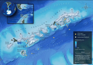
This article is important because it is the first research expedition comprised of an all-Canadian-led scientific team to the Antarctic. From a geospatial perspective, the research incorporated oceanography, geoscience, and cartography to help represent the findings. With the help of adding a mapping perspective, it not only acts as a piece of the data puzzle for visual representation, but also helps visualize trends and datasets in a way that adds to numeric data. Read more about the expedition here and view the public data from the portals here and here. More articles from George.
Jonathan Murphy Publisher of GoGeomatics Canada
Canada Can No Longer Pretend Digital Sovereignty Isn’t at Risk
This GoGeomatics editorial captures a growing reality facing Canada’s geospatial and IT sectors: long-standing reliance on foreign digital infrastructure, platforms, and cloud services is increasingly being recognized as a national vulnerability. The article argues that digital sovereignty is no longer an abstract policy concept but a practical requirement for infrastructure delivery, security, and trusted data systems. For the geomatics community, this shift is especially consequential, as geospatial data, digital twins, and Earth observation underpin many of Canada’s emerging priorities, from Arctic sovereignty to climate resilience and infrastructure investment.
Anusuya Datta
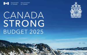
Sovereignty by Design: What Canada’s 2025 Budget Means for Data, Space and Geomatics
Canada’s 2025 Federal Budget emphasizes sovereignty across territory, defence, data, and digital infrastructure. While not explicitly mentioning GIS, it supports a sovereign digital and spatial framework, strengthening Earth Observation, mapping, and geospatial capabilities critical for national decision-making.
Why its important?
Canada’s 2025 Federal Budget prioritizes sovereignty over data, compute, and digital infrastructure, laying the foundation for a national spatial framework. For the geospatial community, this supports Earth Observation, mapping, and GIS capabilities essential for informed decision-making and national planning. More articles from Anusuya
Alefiya SJ
Map of PFAS Contaminations in Canada
CBC News analysis reveals that airports, military bases, landfills, and firefighting sites across Canada are contaminated with PFAS “forever chemicals,” potentially threatening drinking water. Health Canada recommends limiting levels to 30 nanograms per litre, with an interactive map highlighting hotspots.
Why its important?
By mapping PFAS sites in relation to groundwater wells and populations, the interactive tool helps reveal which communities are at risk of exposure through local water sources. This makes the environmental data relevant and actionable at a community level. Maps like this make environmental risks accessible and understandable to the public and policymakers. This multi-layer spatial analysis lets users explore not only where PFAS is found, but how it intersects with human and ecological systems.
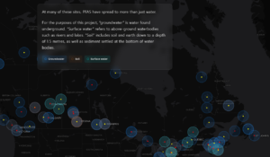
PFAS map is important geospatially because it takes complex scientific and environmental information and turns it into a place-based, visual story that highlights patterns, risks, and connections between contamination and communities across space — which is exactly what geographic analysis is for. More articles from Alefiya


Be the first to comment