Canadian Geomatics & Space Policy & Gov Updates: GeoIgnite Keynotes, Talks, & Panels
This year’s GeoIgnite conference will feature many exciting and informative talks in the area of Geospatial and Space Policy. The conference will also feature federal and provincial government updates.
GeoIgnite is a free event open to everyone in the Canada Geomatics Community. The main conference will run from April 21st to April 23rd and will be presented live in English and French.
Please register at the following link: https://sites.grenadine.co/sites/gogeomatics/en/geoignite2021/register
This year’s Keynotes, Talks, & Panels:
April 21 at 11:30 EST: Canada’s DEM: The National Canadian Elevation Data Strategy Update from NRCan
April 21 at 2 EST: “Making Corporate Decisions using Geospatial Data and the Power of Location Intelligence!” Agriculture Agri-Food Canada’s Agri-Geomatics Manager – James Ashton
April 21 at 3:30 EST: News from the Budget: The Federal Government of Canada Geospatial Director General’s Panel
April 22 at 10 EST: Keynote: Address by Vice-President of the Canadian Space Agency
April 22 at 11:30 EST: Fire Side Chat with Steve Liang, Founder & CTO of SensorUp & Dr. Nadine Alameh the OGC’s CEO
April 22 at 2 EST Talk: Canadian Council on Geomatics – Fostering collaboration across jurisdictions
April 22 at 2:45 EST: Canadian Geodetic Survey – Supporting Accurate Geospatial Positioning in Canada
April 23 at 10:30 EST: Keynote: Barbara Ryan – Executive Director of the World Geospatial Industry Council
April 23 at 2:45 EST: Canada’s Provincial & Territorial Geospatial Leadership Panel
April 27 at 11 EST: ISO/TC 211 – Q&A and membership opportunities in the Canadian national Mirror Committee
To find out more information on the Keynotes, Talks, & Panels, click here.
Mapping project illuminates links between poor environment, historical racism
GoodScore is a mapping tool that can be used to measure the quality of the environment in any urban area in Canada. This tool rates local amenities, outdoor recreation, green streets, transit options, and air quality out of 100 and then gives a location a final score based on these factors.
Most major cities in Canada have a good to fair score.
Vancouver – 77 / Edmonton – 75 / Winnipeg – 75
Toronto – 67 / Ottawa – 81 / Montreal – 67
Halifax – 83
However, when comparing this score to some first nations communities the results are vastly different. The Aamjiwnaang First Nation located near many of the petrochemical plants in southwestern Ontario, has an overall score of under 10 and is as low as 1 in some places. A score this low can have hazardous outcomes for the health of the people living there, this can include a decline in mental health, development of cancer, asthma and diabetes, and low birth weight among newborns.
The creators of GoodScore, government officials, researchers, and those living in vulnerable communities, hope that GoodScore will help redesign cities to reduce health inequalities and address environmental racism to improve the wellbeing of individuals living in those vulnerable regions.
To find out the score of your neighbourhood visit: https://canue-dev.herokuapp.com/
Remote sensing of agriculture reaches new heights
Agriculture Canada has received funding to improve the accuracy of crop-disease forecast models using the Disease Risk Tool (DiRT1). This technology takes user inputs and information from satellites to identify when there is disease risk. Sclerotinia is a type of fungus that can cause disease in canola. Since Sclerotinia tends to thrive in moist environments Agriculture Canada is collaborating with Environment Canada to determine soil moisture, soil saturation relative to field capacity and the duration of soil saturation. Heather McNairn of Agriculture Canada anticipates that this technology at some point will update in near real-time and be used for other crops and other diseases.
Article can be viewed here.
Dinosaur Fossils in Canada Interactive Map
This interactive map shows where dinosaur fossils have been found in Canada with data taken from the Paleobiology Database. Each dinosaur icon with tell you the name of the dinosaur, if it is partially or fully identified, when it existed, the geological period, how many fossils have been identified at that location and the coordinate precision.
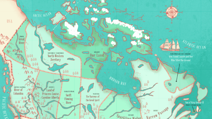
The Literal Translation of Places in Canada and the United States
This literal translation map displays the meaning behind place names in Canada. These distinctive place names tell a story about each province and territory. The article also includes maps that display the meaning behind each state in the United States.
Article can be viewed here.


Be the first to comment