
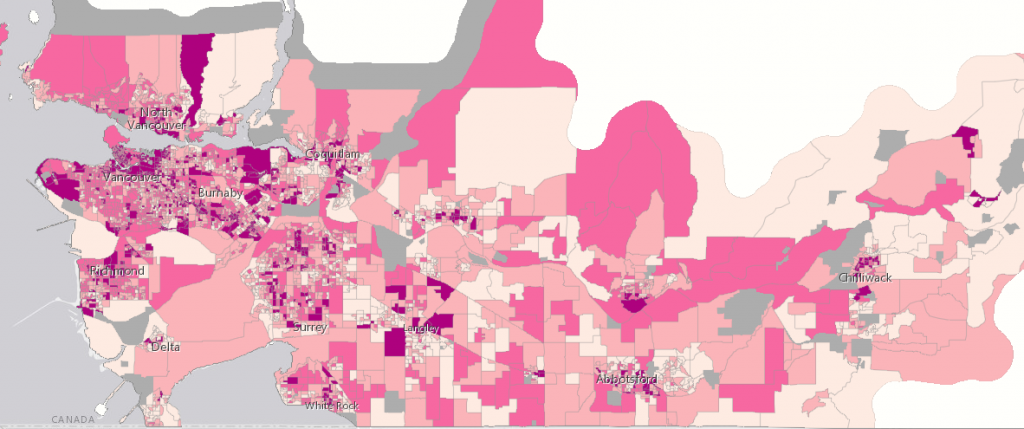
An unequal post-pandemic recovery: mapping the aftermath
Mapping the COVID-19 pandemic’s secondary health impacts is co-led by SFU geography professors Valorie Crooks and Nadine Schuurman outlining how the COVID-19 pandemic’s long-term impacts will affect communities across British Columbia.
Drawing on data from Statistics Canada and looks at five factors contributing to secondary health impacts including: housing insecurity, job insecurity, occupational burnout, loneliness/isolation and educational disruption, each community will face its own unique challenges to recover from the current health crisis
http://www.sfu.ca/sfunews/stories/2021/05/an-unequal-post-pandemic-recovery–mapping-the-aftermath.html
ttps://storymaps.arcgis.com/stories/05ec1a9375684ecabd551c137f4ccefb
Regina youth-led initiative mapping eco-friendly transit problem areas
Ada Dechene and Sydney Chadwick, board members for Fridays for Future Regina, launched the Easy Breezy Bike Challenge, asking Regina residents to submit video clips or photos of themselves using eco-friendly transportations highlighting problem areas and good areas in the city of Regina.
They are hoping to make a map that shows the spots in Regina where eco-friendliness and the fight for climate change needs to be considered, whether walking, cycling, skateboarding or taking the bus to reduce carbon footprints in transportations.
Be on the lookout for abandoned rabbits and how you can help
Let’s get this straight, these cute critters should never be abandoned, but what should we do when we spot one, or a colony? Abandoned Rabbits is run by a group of compassionate volunteers dedicated to tracking abandoned pet rabbits and the subsequent feral rabbit populations. Further, it aims to educate the public about the issue and push local & provincial governments for support.
The Abandoned Rabbit Maps welcome users to report feral, in-distress or abandoned rabbits. Hopefully, volunteers or anyone who uses the map can give them a hand when the bunnies need it. Report sighting through the web map if you spot any feral or abandoned rabbits!
https://map.abandonedrabbits.com/sighting-map
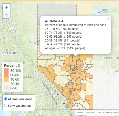
New provincial map gives Albertans regional breakdown of vaccine data
Alberta has released an interactive map that allows Albertans to visualize the number of people in their area that have received at least one dose of the vaccine. It also provides users with a breakdown of COVID-19 vaccination by age groups in each region.
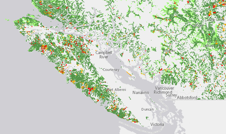
New mapping highlights severe uptick in old growth forests approved for logging
At the time when the logging of old-growth forests in British Columbia stirs heated debates, a new report from Wilderness Committee, a BC-based non-profit, shows a potentially bleak future for old-growth forests across the province. A map highlights areas across the province that have been approved which coincide with old-growth areas.
Fisheries scientist calling on high-tech anglers to reel it in
Steven Cooke, an Ottawa biology professor is calling for limits on the increasingly fancy lures and high-tech gear where some sport fishermen with deep pockets are using drones to drop baited lines, electric lures that flashlights or emit scent.

Elon Musk is sending a Canadian-made Dogecoin satellite to the moon
Calgary-based Geometric Energy Corporation has commissioned Elon Musk’s SpaceX to launch a satellite, the DOGE-1 Sat, next year. According to the company’s press release the satellite with be launched on Falcon 9 in Q1 2022.
https://mobilesyrup.com/2021/05/10/elon-musk-sending-canadian-made-dogecoin-satellite-moon/
OGC Appoints Prashant Shukle to its Board of Directors
Prashant Shukle is currently the Chief Operating Officer of KorrAI, an advanced geospatial artificial intelligence company based in Halifax, Nova Scotia. Shukle is a passionate advocate for the earth observation and geospatial industry, he previously served as the Director-General of the Canada Centre for Mapping and Earth Observation where, among his many roles, he managed Canada’s only geospatial data standards programme, GeoConnections.

Be the first to comment