
- Canada’s Geomatics Expo Surpasses Expectations
- Wildfires in Canada
- SON map project to show connections to land, water
- The World in French? There’s a basemap for that.
- Canada to invest $739m in RADARSAT+
Canada’s Geomatics Expo Surpasses Expectations
The GoGeomatics Expo in Calgary is just one week away. To learn more about what to expect from this event, check out here.
Wildfires in Canada
We brought you recent geospatial stories on wildfires that hugely impact Canada, from West to East, this summer.
- Five charts to help understand Canada’s record-breaking wildfire season: This article provides you with some data visualization tools that help simply understand the impact of wildfire across the country and some methods for predicting future fires.
- Before and after: Damage in wake of Canada’s wildfires seen from space: Around 6,474 fires, have burned up roughly 18.1 million hectares of land this year, equal to almost 17 million CFL football fields according to the Canadian Interagency Forest Fire Centre estimations. This article aims to offer you the Sentinel-2 and Landsat 8 satellites’s images of British Columbia, Yukon and the Northwest Territories, before and after this year’s wildfire events.


Image credit: Canadian Space Agency, contains Copernicus Sentinel satellite data (2023) processed by Dromadaire Geo-Innovations. - James Bay Minerals follows up pegmatite outcrop find with airborne LiDAR at Canada projects
James Bay Minerals (ASX: JBY) is employing airborne LiDAR and high-resolution photography in Quebec over its projects, La Grande and Troilus. James Bay recently revealed a discovery of a large pegmatite over an area of 400 metres by up to 20 metres. It is believed that the recent wildfires caused this large pegmatite.
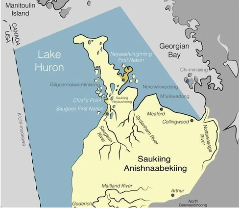
SON map project to show connections to land, water
Saugeen Ojibway Nation people participated in the land use and occupancy mapping project interviews from Oct.21 to Oct.29 to show how the nation used territorial lands and their connection to the land and water.
This project outcome will be a series of maps as a tool in the decision-making process to protect the SON Territory from current or future development consequences. These maps will be useful in future consultations, debates, and processes to make agreements as well as courts. Read more here
The World in French? There’s a basemap for that.
Francophone GIS users used to change the place name language in the ArcGIS Vector Tile Style Editor to create and work on their version of the World Topographic basemap. But this modified basemap can not be hosted in the basemap gallery or the ArcGIS Living Atlas of the World. Also, no data from the Community Map of Canada is included in this basemap.
Now, the Community Map of Canada team is working on a collaborative project with Esri France to present Community Map of Canada data including Canada and global French-labelled place names, incorporating them into one cohesive basemap. Read more here.

Canada to invest $739m in RADARSAT+
The Canadian Space Agency will invest CAD1.012 billion over 15 years in RADARSAT+. The CSA stated that this new initiative will collect data about Earth’s oceans, land, climate, and populated areas. The gathered information will help scientists observe the changes on our planet and make decisions to cope with disasters like wildfires or address long-term problems like climate change. Read more here and here.

RADARSAT+ forms part of Canada’s Strategy for Satellite Earth Observation and aims to help us unlock the full potential of satellite Earth observation. Now more than ever, we’re taking visionary steps to leverage space and maximize benefits for Canadians.
François-Philippe Champagne, Minister of Innovation, Science and Industry, Canada, said.


Be the first to comment