The beginning of 2016 was accompanied with a sonorous press release from the Open Geospatial Consortium (OGC) entitled: “OGC® seeks public comment on a candidate standard that may replace legacy coordinate systems” [1]. In other words, on January 5th OGC requested public comment on the OGC candidate Discrete Global Grid Systems (DGGS) Core Standard.
A Discrete Global Grid (DGG) is a partition of the Earth’s surface into a set of regions (a.k.a. cells) containing a single point and meeting the needs for global sampling, storage, modeling, processing, analysis, discovery, integration, and visualization [2][3]. A Discrete Global Grid System (DGGS) is a series of discrete global grids; a discrete hierarchical tessellation of progressively finer resolution cells.
It is important to make clear that not any partition (a.k.a. tessellation) of the Earth’s surface does necessarily result into a DGGS. A tessellation of cells must meet a set of criteria to be considered as a DGGS, including [2][3]: global coverage, equal area cells, single point representation per cell, and multiple levels of granularity. The most widely used tessellation of the Earth’s surface is based on the geographic coordinate system with cells defined by arcs of equal-angle increments of latitude and longitude, e.g., 10ox10o, 1ox1o, 6’x6’, etc. The resulting grid is very convenient and offers a straightforward definition. However, it generates cells with variable shape and size at each resolution level and violates one of the criteria of DGGS. Another widely used tessellation is the tiling system introduced by Google on top of the Web Mercator projection of the Earth [4]. This tessellation partitions each tile into 256×256 equal area square cells, however, these cells also fail to correspond to equal-sized areas on the Earth’s surface. In addition, the Google Maps tiling scheme is not global as it does not cover areas with latitude greater than 85.0511 degrees.
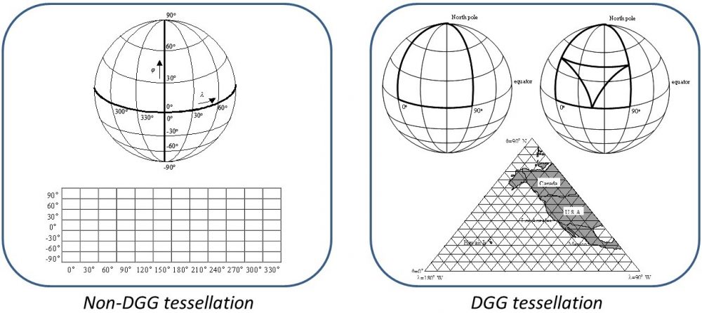
There is a wide collection of tessellations that meet the criteria of a DGGS. Most of these conformant DGGS were introduced and investigated in the two decades 1980-2000. A sound theory and taxonomy of DGGS has already been available [5], while OGC having recognized the value of DGGS has established the Discrete Global Grid Systems Standards Working Group (DGGS-SWG) [6] with goal “to increase the awareness of the advantages of DGGSs”.
A variety of design choices has led to the generation of a wide collection of DGGS alternatives. These choices include [5],[7]: a base regular polyhedron (platonic solid [8] like the octahedron or icosahedron), the orientation of the polyhedron relative to the Earth, the partitioning method of the polyhedron’s faces (such as the 4-fold or 9-fold triangle and hexagon partitions), the mapping of the partition to the Earth’s surface model (direct tessellation of the spheroid or inverse projection of the partitioned plane to the spheroid), and the point representation method of the resulting cells. Each alternative DGGS has its own advantages and disadvantages, while it is highly unlikely that any single DGGS will ever prove optimal for all applications.
Aligned to this latter argument, OGC does not intend to establish a single DGGS as a standard for geospatial applications. On the contrary, the proposed standard [9] includes a definition, the essential characteristics, and the core functional algorithms to support the operation of a conformant DGGS. After approval, the creation of a registration system for DGGS analogous to the registration of Coordinate Reference Systems (CRS), as well as extensions to functional algorithms and schemas of both the core standard and other OGC specifications are anticipated.
DGGS may not “replace legacy coordinate systems” but they will certainly play a significant role in geospatial data handling as they provide a fixed geospatial reference frame that enables the integration and interoperability of multiple voluminous spatial data and processing resources.
References and Further Reading
[1] OGC Press Release http://www.opengeospatial.org/pressroom/pressreleases/2349 [Visited Jan. 16th, 2016]
[2] Goodchild, M.F., and Kimerling, J.A., 2000. Discrete Global Grids. A Web Book http://escholarship.org/uc/item/9492q6sm#page-1 [Visited Jan. 16th, 2016]
[3] Publications of the Global Grid Research Group, 1992-2008. US Environmental Protection Agency, Oregon State University, and US Forest Service. http://cartography.oregonstate.edu/global_grid_project.html [Visited Jan. 16th, 2016]
[4] Stefanakis, E., 2015. Map Tiles and Cached Map Services. GoGeomatics. Magazine of GoGeomatics Canada. December 2015. http://www.gogeomatics.ca/map-tiles-and-cached-map-services [Visited Jan. 16th, 2016]
[5] Kimerling, A.J., Sahr, K, White, D., and Song, L., 1999. Comparing geometric properties of discrete global grids. Cartography and Geographic Information Systems 26(4):271-287. http://people.oregonstate.edu/~whitede/attachments/Kimerling_etal_CAGIS_1999.pdf [Visited Jan. 16th, 2016]
[6] OGC Discrete Global Grid Systems SWG http://www.opengeospatial.org/projects/groups/dggsswg [Visited Jan. 16th, 2016]
[7] Sahr, K., White, D., and Kimerling, A.J., 2003. Geodesic discrete global grid systems. Cartography and Geographic Information Science 30(2):121-134. DOI: http://dx.doi.org/10.1559/152304003100011090
[8] Platonic Solids, Wikipedia https://en.wikipedia.org/wiki/Platonic_solid [Visited Jan. 16th, 2016]
[9] OGC Discrete Global Grid System (DGGS) Core Standard. Submission Date: 2015-09-30. https://portal.opengeospatial.org/files/66643 [Visited Jan. 16th, 2016]


Be the first to comment