Back in March, GoGeomatics Canada introduced the Esri Canada Centres of Excellence App Challenge while the competition was still underway. The contest ended on March 6, and we’re bringing you the results and descriptions of the winning apps below.
Ten teams from six of the seven ECCE centres across Canada submitted their apps. Organizers were impressed by the way students used Esri’s new tools, often for the first time, to build apps that hold major promise for future development. The challenge saw submissions from students at:
- The University of Waterloo
- NSCC Centre of Geographic Sciences
- McGill University
- McMaster University
- Simon Fraser University
- University of Victoria
Teams had only one week to complete their apps using open spatial data and any aspect of the Esri software platform to develop an app on some aspect of government services in Canada for any of these themes: Housing; Health; Parks and recreation; Education; Public/private transport including infrastructure; Garbage collection/snow/branch removal; Emergency management; Information services; or Utilities.
The competition was judged by an impressive panel of experts in geomatics. The judging panel included: Andrew Turner, CTO at the Esri Research and Development Centre in Washington, DC; Jan Kestle, President and Founder of Environics Analytics; and Elaine Dawson, Director of DataBC, Government Communications and Public Engagement, Ministry of Advanced Education. After a two-week deliberation period, the top three teams were announced on March 21.
First Place: PredictION
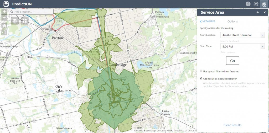
First place went to Team-SDS from the University of Waterloo. Teammates Jonathan Van Dusen, Maju Sadugopan, and Shanqui Zhang created the PredictION app, a transit modelling and routing tool, to help citizens visualize, analyze, and compare routes and service areas between existing and proposed transit systems in the Waterloo Region.
The app is designed to demonstrate the impact on travel times and service areas of the coming ION Rapid Transit lines to the region’s Grand River Transit network. The developers integrated, processed, and displayed various open datasets, including road and bus networks, transit routes and schedules, regional boundaries, and local points of interest. They also used Esri’s Web AppBuilder for ArcGIS (Developer Edition) to create a highly visual and easy-to-use analysis tool for comparing current and proposed transit services.
Second Place: Community Open Data Engage (CODE)
The McGill University team’s app, made up of Matt Tenney, Jin Xing, and Carl Hughes, aims to help citizens better understand the neighbourhoods they live in through the use of open data. This team sought to touch on all the themes in the app challenge to allow citizens to explore and make sense of their community through visualizing comprehensive neighbourhood profiles. The app also provides a platform for citizens to engage with each other through social media and volunteered content that can help connect people in their local areas. The CODE team use the Web AppBuilder with extensive custom coding.
Third Place: EPICentered
TeamSFU from Simon Fraser University submitted the only native smart phone app in the competition. Team members Sonja Aagesen, Ian Lochhead, and Tom McKay developed EPICentred for iOS 8.1 and optimized for the iPhone 6. It is a location-aware earthquake preparedness application for users in the City of Vancouver. EPICentered displays a basemap with a set of toggleable layers that are relevant to a citizen in the event of an earthquake, including hospitals, clinics, community centres, disaster staging areas, emergency operations centres, fire halls police stations, and schools.
Once the “Get Started” button is pressed, EPICentered calculates the closest emergency muster location to the user from their current location, based on walking time. The user can then examine or walk this route to reach a safe location, as well as visualize important nearby locations in order to understand their best response to an earthquake.
“Great Potential for Future Enhancement”
Organizers explain that it was extremely difficult to single out a clear overall winner, as the other seven submissions were all outstanding. One submission of note was a single-person team, “Enjoy Your Coast BC,” from Caty Brandon of the University of Victoria, who used a development environment she had never seen before the competition started.
Other submissions included:
- “Pan American Games Free Bike” by Nicole Serrafero, Jing Yan, and Jasmine Hunter of COGS
- “Let’s Walk!” by Mark Kirby, Ryan Ruthart, and Katelyn Page of COGS
- “Open Wi-Finder” by Robert Smith, Matt Kalebic, and Suthee Sangiambut of McGill University
- “Skate, Swim, Gym Hamilton” by Stephanie Koehl, Alexandra Usyk, and Craig Allison of McMaster University
- “Zephyr” by Jaydeep Mistry, Graeme, and Sam of University of Waterloo
- “Watermelon Food Inspection” by Jingwen Huang, Qing Lu, and Chen Chen from the University of Waterloo
Dr. Brent Hall, director of Education and Research at Esri Canada and the initiator of the App Challenge, comments that “the competition was a huge success with all centres of excellence…. Virtually none of the students had done any concerted app development with Esri software prior to the event, and within a week they were able not only to produce outstanding apps, but also to develop a video pitch, a mission statement for their app, and get their code plus a working prototype ready for the judges. Many of the apps have great potential for future enhancement and development, and I would like to see the creators not only back for next year’s competition, but also to see them work further with what they developed. We look forward to an expanded competition next year as we add several new centres to the network.”
This contest allowed students to try something new, and explore how these tools can have a practical impact for society. Readers are highly encouraged to visit the GitHub repository, where they can experiment with all the apps submitted.


Be the first to comment