
New Wyoming Mapping Project Helps Identify Important Habitats for Protection
A new mapping project by the Wyoming Game and Fish department identifies all of the priority habitats in the state. Using GIS to identify and create the habitat maps, the department hopes to outline areas for conservation and protection. The service also includes information about the prioritization of habitat protection. To gain public support for the project, they have included GPS tracking data from tagged animals. This will help endear the project to the public while also creating a better sense of where the animals spend most of their time. For more about this story, check it out here.
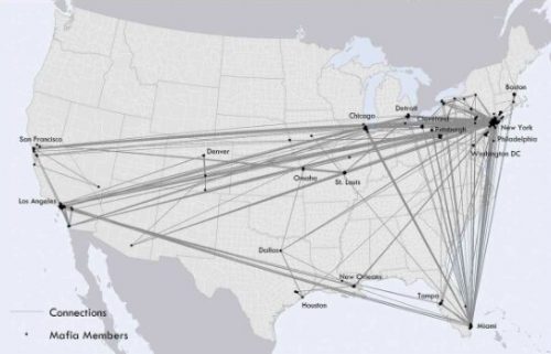
Map of the Mafia Gives Deeper Insights into Former Operations
Researchers from the University of Pennsylvania State have been working on a new project for American Mafia families from the 1950s and 1960s. By plotting known locations of different Mafia members, extracted from a dossier from 1960, they could locate Mafia families around New York. They found that Mafia family members typically “lived within about 18.5 miles of their family’s median center in the city.” and that “High-ranking members tended live near the center of those areas.” For more information about the Mafia’s geographic distribution, how it can be used to predict relationships between members, and what it could mean for criminologists today, check out the article here. For a deeper read, you can also head on over to the research paper published in the International Journal of Geographic Information Science.
Animated Map Shows History of Earthquakes and Tsunamis Around the World
2021 has been a year of active tectonic processes. Earthquakes have shaken cities from the South Pacific to the Mediterranean, and volcanoes have been active on many continents. With these events on the minds of many, the Pacific Tsunami Warning Centre has recently shared a video created to illustrate every recorded earthquake and tsunami since January 1, 1901. To check it out and learn more, you can find it here.
OGC API Allows Vector Data Transmission in Any Coordinate Reference System
The Open Geospatial Consortium has recently announced changes to their API allowing for the transmission of vector geospatial data in any coordinate reference system. This new ability is a big step for open data capabilities, as the API previously required everything to be transformed into WGS 1984 before transmission. This is exciting news for users who typically work in other coordinate reference systems, who no longer have to transform their data. This development is a step towards maintaining higher data quality for users everywhere. For more about what this could mean for you, check out the story here.
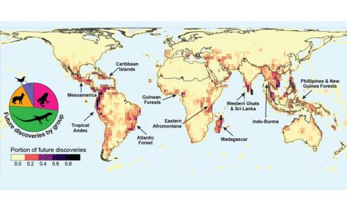
Interactive Map Could Help Scientists Discover Previously Unknown Species
After an exhaustive study of over 32,000 existing species, scientists have created an interactive map to identify regions most likely to harbour species previously unknown to science. Mario Moura and Walter Jetz are the scientists leading the project. Writing in the journal Nature Ecology & Evolution, they have identified hotspots of diversity they believe are most likely to harbour unidentified species of mammals, birds, reptiles and amphibians. Humans have only identified and classified an estimated 20% of species on Earth, meaning there could be millions more out there still to discover. The interactive application allows you to pull up different maps of hotspots for the various animal classes. For more on this story, check it out here.
Be the first to comment