ISS dodges its 39th piece of potentially hazardous space junk. Experts say it won’t be the last
NASA AI, Open Science Advance Disaster Research and Recovery
NASA satellites reveal Earth’s Continents are getting drier
Sentinel-1C fueled ahead of liftoff
It’s no just a game. Your Pokémon Go player data is training AI map models
ISS dodges its 39th piece of potentially hazardous space junk. Experts say it won’t be the last
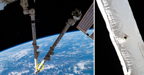
On November 19, the International Space Station (ISS) engaged in its 39th space junk collision maneuver. Space junk is defined as any human made material remaining in space after its intended use. Pieces of space junk have become an increasing threat to the ISS, with debris reaching speeds of 29,000 km/hr – roughly seven times the speed of a bullet. Damage to the Canadarm on the ISS: Image Source – NASA/Canadian Space Agency
The problem of space junk is an ongoing issue made worse by “anti-satellite tests”, which is when countries destroy unwanted satellites in orbit. Several countries, including the United States have pledged to end the practice of anti-satellite tests, but regardless, management of defunct satellites remains a problem. There is already an estimated 9,000 metric tonnes of human made debris in space. Read more here
NASA AI, Open Science Advance Disaster Research and Recovery
Several NASA programs are building tools and advancing science to help communities make more informed decisions for disaster planning.
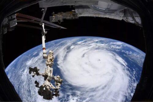
The NASA Disaster Program is designed to provide timely and effect information to assist with disaster management. The Disaster Program played a significant role in the response to the 2021 Hurricane Ida, providing information about changes in vegetation, precipitation accumulation, flood information and nighttime light levels associated with power outages.
A picture of Hurricane Ida seen from space: Image Source – NASA
NASA is currently working with IBM to develop five open source AI models built with NASA data. These AI models are planned to help identify flood risk, estimate crop yields and to forecast long range atmospheric patterns. Read more here
NASA satellites reveal Earth’s Continents are getting drier
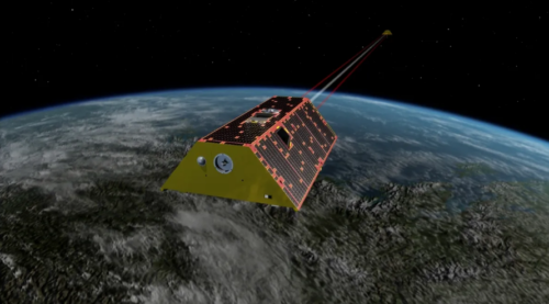
NASA’s GRACE satellites have revealed a substantial and ongoing decline in Earth’s freshwater supply since May 2014, marking a critical environmental shift. An international team of scientists reviewed GRACE data, which measures changes in Earth’s gravity to detect variations in water levels both on the surface and underground.
An artist’s rendering of a GRACE Satellite orbiting Earth: Image Source – NASAThe findings indicate the total global freshwater between 2015 and 2023 was approximately 290 cubic miles (1,200 cubic kilometers), a stark indication of dwindling resources. Researchers suggest this decline could signify that Earth is undergoing an unusually dry phase, raising concerns about long-term water availability. This emphasizes the importance of continued satellite monitoring to understand and address global freshwater challenges. Read more here
Sentinel-1C fueled ahead of liftoff
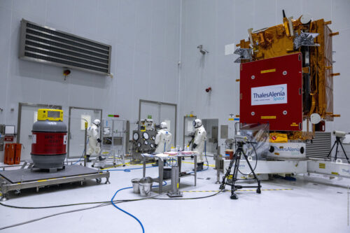
In December, the European Space Agency (ESA) will launch Sentinel-1C, extending the life of the Sentinel-1 constellation impacted by the loss of Sentinel-1B in 2022 due to technical issues. The Sentinel-1 constellation is run by the ESA as part of the Copernicus Programme, providing remote sensing data for applications such as the surveillance of ships and marine habitats, forest, soil and water management and humanitarian and crisis aid.
Filling up Sentinel-1C with fuel before launch: Image Source – ESA
Next year, ESA will launch Sentinel-1D, which will replace Sentinel-1A. The newly upgraded constellation of Sentinel-1C and Sentinel-1D will have an improved radar system, being able to locate ships which have not activated their automatic identification systems. This will be useful for tracking vessels which may be engaging in illegal activities. Read more here
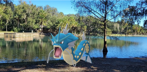
It’s no just a game. Your Pokémon Go player data is training AI map models
Niantic, the creator of Pokémon GO, has recently announced the ongoing construction of an AI model mapping the real world based on player data. While entirely optional, a major component of the Pokemon GO has players take images of real-world locations. Already, Niantic has spend the last five years building a virtual positioning system (VPS) allowing for picture input to determine a players location and orientation on a 3D map. Presently, players have scanned 10 million locations from around the world.
An example of a Pokémon in augmented reality: Image Source – Dinah Pulver
It is becoming increasingly common for companies to collect and use player data. Niantic notes their unique nature of their players’ data – with samples being collected from a “pedestrian perspective” and from locations otherwise difficult to access by vehicle. There are concerns about privacy and while Niantic states that they don’t sell customer data and have a separate policy for younger players, there are still risks associated with any company holding so much personal information. There are several steps that can help users reduce their data risks, including only playing Pokémon GO in public places, minimizing imagery of others and becoming familiar with data policies. Read more here
How are the GoGeomatics Briefing created?
All across Canada, our volunteer editors and group writers gather virtually, on a weekly basis, to discuss and share the newest geospatial news together. Each Writer prepares a few interesting articles that they have researched about, and they share why the reason behind selecting their piece with the other writers. Each researched article is selected based on the relevancy, credibility and interest to the geospatial community. After the team shares all their researched articles, all members vote on the most relevant pieces to write a briefing about.
Our volunteers’ dedication is very valuable to our community. Their efforts embody the spirit of what it means to really be the change you wish to see in the community.
Satellite Data and AI Support Water Monitoring and Climate Resilience AI and GPU Acceleration Move Geospatial Processing Closer to Real-Time and Into Orbit China Expands Large-Scale Ocean Mapping With Strategic and Military Implications Strait of […]
How changing international relationships create new opportunities for technical collaboration Last year, in my keynote at GeoIgnite 2025, I spoke about how Canadian geospatial innovations can tackle environmental problems. I mentioned, for instance, RADARSAT’s Arctic […]
“Data is the new oil.” Just as petroleum and electricity powered and transformed the 20th century, data is now driving the digital paradigm and shaping the global economy of the 21st century. It fuels innovation, […]


Be the first to comment