
-
National Geographic Society and Utrecht University Launch World Water Map.
-
How to use free satellite data to monitor natural disasters and environmental changes.
-
Russian Offensive Campaign Assessment, March 20, 2023.
-
FNT Software unveils 3D Visualization to its GeoMaps Solution.
-
We need to finally complete a national spatial data infrastructure.
National Geographic Society and Utrecht University Launch World Water Map
The National Geographic Society has launched the World Water Map, which aims to help understand freshwater shortages and inspire sustainable action.
The map, created in collaboration with Utrecht University and Esri, uses one of the most advanced open-source models to track water availability worldwide. It offers an interactive view of water usage in sectors such as agriculture, industry and households, and highlights 22 global water scarcity hotspots.
The tool also identifies areas where water demand outstrips supply, or the “water gap,” and offers stories from National Geographic Explorers documenting freshwater challenges in their communities and sustainable solutions. Read more in detail here.
How to use free satellite data to monitor natural disasters and environmental changes
Access to satellite data for monitoring environmental changes has become more accessible thanks to open-access data from government satellites such as Landsat and Sentinel, and free cloud-computing resources like Amazon Web Services, Google Earth Engine and Microsoft Planetary Computer.
This allows anyone to gain insights into environmental changes underway, from tracking changes in the Amazon rainforest to monitoring natural disasters such as volcanic eruptions and wildfires. Free and user-friendly programs like Snazzy-EE-TS-GIF and Planetary Computer Explorer make it easy to create time-lapse animations of satellite images. Landsat, Sentinel, and GOES satellites are among the most useful Earth observation satellites available for monitoring environmental changes. Find out more here.
Russian Offensive Campaign Assessment, March 20, 2023
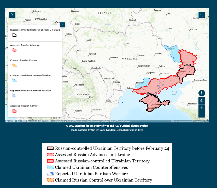
The Institute for the Study of War (ISW) provides daily assessments of the Russian invasion of Ukraine, including static control-of-terrain maps, which are available on their website.
ISW also offers an interactive time-lapse map that shows a dynamic frontline, complementing the static maps. The interactive map requires hardware acceleration for optimal performance, and it is recommended to view it on a computer or large-screen tablet. ISW plans to update the map monthly. ISW assesses that the Russian spring offensive is approaching culmination, and Russian forces may be intensifying efforts to make even marginal gains before losing the initiative in Ukraine. Collect details here.
FNT Software unveils 3D Visualization to its GeoMaps Solution
FNT Software has released FNT GeoMaps 4.1, a new version of its Cable and Outside Plant Management solution. Powered by Esri ArcGIS, the solution provides advanced geographic features for the management of passive infrastructure with spatial intelligence.
The new 3D view functionality allows users to visualize where cables and other passive equipment are within a building. FNT GeoMaps now displays infrastructure assets on floor plans according to their location and height, with seamless navigation between inside and outside infrastructure, and enables users to edit objects on floor plans and filter data by building or floor layer. Read more here.
We need to finally complete a national spatial data infrastructure

Building a National Spatial Data Infrastructure (NSDI) is crucial to help the US respond to and prepare for natural disasters, as well as to better understand risks and vulnerabilities in communities.
However, despite some progress, there are still large gaps in data availability and duplicative work due to a lack of coordination. The creation and sharing of data have been the focus of the NSDI since 1994, but there needs to be an increased emphasis on the application of shared data for improved decision support.
A shared, next-generation NSDI requires a national approach in which all interested parties coordinate as a unified, connected whole. Read more about this here.


Be the first to comment