
Climate change is no longer a distant threat—it’s a present-day reality.
Marked by rising summer temperatures, elevated sea levels, and a growing prevalence of extreme weather events.
Talking about wildfires, they are now more frequent and severe, while floods—once considered centennial occurrences—are becoming alarmingly common.
Alongside these dramatic events, there is a quieter but equally concerning trend: the gradual decline of water levels in lakes and reservoirs. This phenomenon is largely driven by prolonged droughts, shifting precipitation patterns, and escalating demands for water due to population growth and urban expansion.
As cities grow and the need for hydroelectric power intensifies, stress on water resources mounts. Within this broader context, this discussion will focus on Lake Mead—an emblematic case of the environmental, social, and economic impacts of climate-induced water scarcity.
History of Lake Mead
Lake Mead is the reservoir formed by the construction of the Hoover Dam, a remarkable feat of engineering, situated in the Southwestern region of the United States. It spans the states of Nevada and Arizona, approximately 24 miles (39 kilometers) east of Las Vegas.
As the largest reservoir in the United States by water capacity, Lake Mead serves as a critical water source for the states of Arizona, California, and Nevada, in addition to supplying water to certain regions of Mexico.
This reservoir supports the needs of nearly 20 million individuals and irrigates extensive agricultural areas. A ghost town called St. Thomas, which was aligned with Lake Mead, was once submerged due to the overflowing lake and was ordered to evacuate in the 1930s.
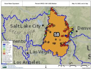
Since then, Americans have been observing the fluctuating water levels of Lake Mead, drawing connections between various factors. At present, the Colorado River has shrunk by 20% since 2000.
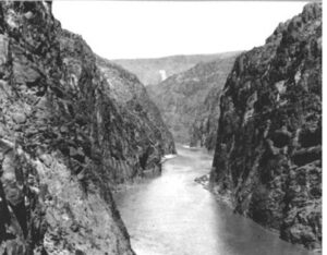
Shrinking Lake Mead from Space
The Landsat 7 images from NASA confirm that the reservoir is currently at its lowest level since it was filled in 1937. Various studies have claimed climate change to be the main reason. From reduced snowpacks, increased evaporations resulting into more dry weather has resulted in the steep decline in the lake’s water levels.
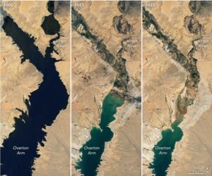
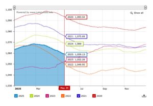
As of July 2022, Lake Mead was filled to just 27% of its capacity. Looking at this year’s graph, the water levels of the lake look daunting. Better than 2022, but still 10 feet lower than last year.
Another major factor is claimed to be the rising populations in urban centers such as Phoenix and Los Angeles have escalated the demand for water resources necessary for consumption, and agricultural irrigation.
Between 2000 and 2023, the population of the Las Vegas metropolitan area went from 1.38 million to 2.33 million, which is an increase of around 69%, according to USGS. In 2025, an estimated 2.4 million will live in the area.
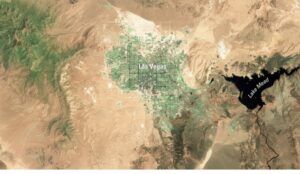
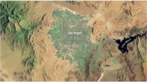
The final image captured from the recently retired(June 2025) Landsat 7 satellite depicts the extensive urban development of Las Vegas, situated in the center of the Mojave Desert.
These final photographs serve as a reflection of one of the satellite’s initial images, showcasing the significant growth of “Sin City” over the course of the satellite’s 25-year operational period.
If you look closely, the Lake Mead on the right side of the imagery has diminished in that time span.
This increased population has subsequently fueled urban development, resulting in the proliferation of urban heat islands, including infrastructure such as roads, parking lots, and buildings. These developments exacerbate the warming of these cities, which are already characterized by naturally arid conditions.
A study called The Press and Pulse of Climate Change: Extreme Events in the Colorado River Basin” can be found in the Journal of the American Water Resources Association. The author has posited a bold claim that “The current projections of warming may compel both human populations and natural ecosystems to reach their respective limits, commonly referred to as a tipping point”.
What We Must Remember
The alarming decline of Lake Mead, clearly visible from satellite imagery, is more than a visual warning. While future climate change is anticipated to lead to higher precipitation levels across the United States, the increase in temperatures will likely result in greater evapotranspiration, which will counteract this effect.
As a result, overall water yields are projected to significantly decrease, potentially dropping by more than 30% of current levels by 2080 in certain scenarios.
According to the National Oceanic and Atmospheric Administration(NOAA), “Drought conditions in the Southwestern US have been improving since August 2020, but long-term drought effects will still be present for years to come”.
This shows that climate change is still running rampant, and it is a major concern that requires a safe, sustainable solution for a healthier planet.


Be the first to comment