
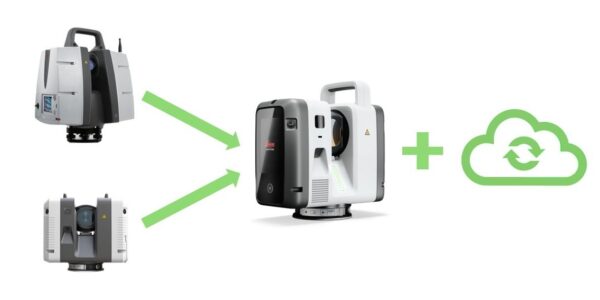
The best features of two successful terrestrial scanning systems have been merged into a whole new platform. And, simultaneously released, a companion workflow-streamlining solution.
Like a lot of folks, when I saw the first images of the RTC300/500/700 series and looked at the specs, I wondered if it was a mash-up of the Leica Geosystems P-Series and RTC360 terrestrial scanners. “It’s not just an improvement of an existing thing, and not just like adding certain things,” said Juergen Mayer, Head of Reality Capture Product Portfolio. “It’s really a new scanner altogether.”
“It’s really a new scanner altogether.”
“All the things that people loved about the P-Series, you know, the survey grade type aspects of it, the range, the accuracy, the robustness, the accuracy at range, we were sure to preserve these,” said Mayer. “And the RTC360, which is all about performance and speed and versatility, in the end, we put that together into one platform while improving many aspects of both.”
That must have been an interesting proposition to pose to the R&D teams. Both series were already popular and successful, but they didn’t want to stop there. “We didn’t just want to release a new hardware update,” said Mayer. “We are really releasing a series of scanners, offering this in three variants at different levels of performance, to give our customers a choice of picking the right product for the right task.”
This development will not be a surprise to many end users who have been speculating about what might come next for the P-Series (which has been around for a long time), and which features of the newer series, like the RTC, might be integrated into something new. Yep, this was destined to happen, and that’s a good thing.
There is another capability that dovetails with the release of this new scanner series. “It was really important to us to add something on top,” said Mayer. “That’s a new way of working: enabling real-time collaboration across teams, connecting the people in the office with the people in the field.” This capability has been dubbed “Livelink”. But more on that later—let’s dive into the hardware.
The New Scanner Series
I wondered if they had just taken bits and pieces, components from each, and put them in a new box. “It was really developed from scratch,” said Mayer. “Which is also important for us; this is meant to be the new platform for more improvements to come. So, to innovate and future-proof, we built in things that we’re not even exploiting to the full extent—yet. For example, there’s an AI chip (neural processing unit) in there. We have plans to use that for, let’s say, more intelligent ways of capturing the data. In the future, we will introduce a mode where image-taking will happen simultaneously with scanning, so that’s already designed in and will be delivered in the form of software updates.” This is similar to the approach taken for the recently released Leica TS20 robotic total station: enhanced, smarter capabilities up front, with more in the works. With NPU, the essential surveying tool is getting smarter.
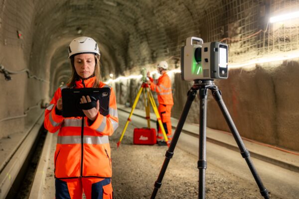
Like the RTC360, the The P-Series has long been the “big gun”: survey-grade, long-range, and highly precise, but even it tops out at 1 million points per second. So, right out of the gate, there’s an across-the-board improvement. The new scanner also provides the two main methods for spatial registration. First is conventional, like with Cyclone Field 360 and Register. But you also have the option of progressive, real-time registration, as with the RTC360, using VIS (Visual Inertial System).
Imaging has become an indispensable part of reality capture; you seldom see production scanners without it nowadays. But mostly, you have to do the scan run and a separate camera run. This has been updated in the new system. “The photo run is half the time it was before, because we’re using a full camera ring,” said Mayer. “Instead of three cameras that take the pictures, it’s now six cameras; you only need something like a 180-degree turn. This was a precondition for what we have planned: simultaneous lidar and images.” While simultaneous capture is not part of this early release, Mayer says it soon will be, again through a future firmware update.
I asked about one feature of the P-Series that is near and dear to surveyors: the traverse capability.
“Yes, this will definitely be enabled in the future as well,” said Mayer. “It will be one of the differentiators available on the RTC700, the highest-performance model, supporting total-station-like workflows for setup. The ability to measure a target as an individual scan in the field, to accurately measure the centre of the target in the field, will enable things like setting up on a point, resection, and traverse-like workflows. Not in this release, but soon.”
The Models
The three models are the RTC300, RTC500, and RTC700. Essentially, they are the same in most aspects and workflows, but with tiered performance levels to suit different end uses and price points. The 700 and 500 collect at 2MHz (at any range), are self-calibrating, IP55-rated, have a minimum range of 0.5m, an image resolution of 1.6mm and 3mm at 10m respectively, 3D accuracy of 1.5mm at 10m and 3.8mm at 50m, and range noise of 0.2mm at 10m and 0.4mm at 50m. They are about the same size and weight (about 5.5kg without batteries) as an RTC360, with a similar form factor that includes a handle for easy carrying.
- RTC700: Top-tier, survey-grade system. Range up to 270m, 1.6, 3, 6, 12, 25mm at 10m and an area scan of 0.8mm at 10m. Envisioned for detailed scans and for applications like large-scale infrastructure and plants. It is designed for full survey workflows, and this could be the new “big gun” scanner.
- RTC500: This has a 130m range, is more like an RTC360 in workflow (e.g., basic resection survey workflow), yet is like the 700 in all other aspects. Envisioned for applications like public safety, infrastructure, construction, and smaller-scale surveying.
- RTC300: This has a range of 85m and captures points at 1MHz. Envisioned for construction and mixed reality capture applications. It provides the opportunity to leverage most of the features of the RTC series at a practical entry point, and has the capacity to carry out basic resection survey workflows.
Live Linking
As Mayer had noted, one of the goals of this update to the series was not just to be faster and smarter, but also to improve the workflows: how to manage projects, get feedback on progress and quality, and begin processing even while the fieldwork is underway. I have seen folks take photos with their phones to send to the office to ask if they captured everything. Yes, there had to be a better way.
“The first pillar of Livelink is remote reviewing of the scan preview, even as it is still scanning. We added the ability for the project lead, even if they are in the office, to advise the person in the field, live,” said Mayer. “Because very often, people in the field might not be the most experienced when it comes to interpreting the data. So having that benefit of being able to get consultancy from a more experienced person in the office is a big thing, and then obviously you can extend this to multiple users, multiple scanners, many combinations.”
“The second pillar is collaborative input,” said Mayer. “It could be multiple field crews that all, in real time, simultaneously see how the whole project is progressing. Everyone knows what the others are doing, in the field as well as in the office. Not just the people collecting data, but also others, and some people adding information, like tags.”
“The third pillar is the ability to send data via the cloud to the office while you’re still in the field,” said Mayer. “Basically, you’re shortening the whole field-to-finish timeline when it comes to creating a deliverable. Rather than this being a sequence of steps where you collect the data, then drive to the office, then offload the data, you send the data to the cloud right away, and production of final deliverables can actually start while people are still in the field. Someone can work on the registration to the point where someone else can analyse the data and send the results back to the field for decisions that need to be made quickly and are required on the spot.”
But what is Livelink? Are you thinking, “Oh no, another app, another product in a labyrinth of products?” There’s a lot of remote connection and cloud tools already, even within the Hexagon/Leica portfolio. Sometimes manufacturers create new ones faster than we can forget the old ones. There’s Reality Cloud Studio, Leica Exchange, Protect, ConX, Active Assist, etc. The good news is that there’s been some consolidation.
“Livelink is not the product; Livelink is a capability within Hexagon GeoCloud,” said Mayer. “GeoCloud replaces what used to be RCS, Reality Cloud Studio, and the old incarnation of GeoCloud that was separate, so everything is now combined under one product. The workflows for this new scanner, in particular, can benefit from this consolidation of capabilities.”
Of course, the cloud is not always available in places where internet connectivity is slow, spotty, or nonexistent, though there has been great improvement in the era of 5G and carriers duking it out. Even if it is available and reliable, you’re capturing 2 million points per second; which features of Livelink would be practical? Management and support certainly. Even if you might still need, in some instances, to pull out the data chip back in the office, there’s still a lot you can do.
“What we recommend, depending on the task you’re doing, is that if it’s a co-ordination task, you might just want to use lightweight output,” said Mayer. “What you see in Field 360, although it looks very complete, is actually a reduced, preview data set. Visually, you might not notice a big difference between the full data and this preview data. So, for someone in the office to judge whether something’s missing or even to do things like checking floor flatness, that would be completely sufficient. For fast decisions, use the preview data. But you are still storing the full data because you need that for the final delivery.” Yes, your manager can say ‘hey, you missed a spot’ from the office while you are still in the field.
Yes, your manager can say ‘hey, you missed a spot’ from the office while you are still in the field.
And if you do have a fat pipe to the cloud, the processing of the deliverable can begin immediately, even while you are driving back to the office.
There have been many developments in geomatics hardware, software, and workflow tools across the industry that have been in the works for many years, and we’ve seen early implementations (some have at times been more a source of frustration than jubilation). This mash-up of two successful solutions and the bonus productivity tool was, in many ways, inevitable, and hopefully this is a sign of even better things to come.
Beep on!

Be the first to comment