")
The Country You Cannot Watch from the Ground
In March 2026, the Canadian government announced a $200 million investment in core infrastructure for a Canadian-owned spaceport, along with other major new space-related capabilities and initiatives. The announcement was historic. For over sixty years, Canada has been a respected spacefaring nation but has always relied on international launch providers.
That same government, just months earlier, had written a cheque worth over $664 million to the European Space Agency, the largest single Canadian investment in ESA programs in history. More partnerships. More interdependence.
On the surface, these two moves look like they are pulling in opposite directions. One says: we go alone. The other says: we go together. For a country navigating an increasingly unpredictable geopolitical environment, the question of which instinct to follow has real consequences. Not just strategically, but for every geospatial professional, every Earth observation scientist, and every decision-maker whose work depends on satellite data flowing uninterrupted from orbit.
The answer, it turns out, is not a choice between the two. And the person best positioned to explain why is Guennadi Kroupnik.
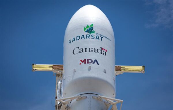
Kroupnik is the Director General of Space Utilization at the Canadian Space Agency, the engineer, executive, and internationally recognized satellite expert who has spent more than thirty years building and running complex space missions. He led the development and operations of the RADARSAT Constellation Mission, Canada’s flagship Earth observation mission. He represents Canada on the Committee on Earth Observation Satellites. He has testified before the National Defence Committee on space security. Some individuals operate at the intersection of sovereignty, collaboration, and the technical realities of observing Earth from space. Mr. Kroupnik is one of them.
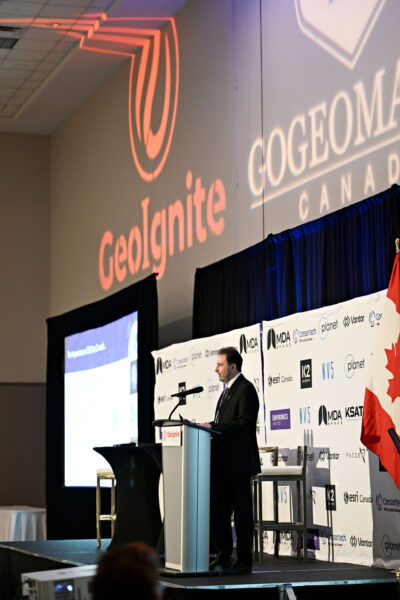
We spoke with him at GeoIgnite 2026 in Ottawa, where he had just finished presenting on Canada’s satellite Earth observation strategy. What he said clarifies something the policy announcements alone cannot: Canada is not choosing between independence and interdependence. It is learning, with considerable sophistication, when to depend on which.
But to understand why that matters, you first have to understand what is actually at stake.
Geography as Destiny
Canada is the second largest country on Earth by landmass. It has the longest coastline in the world. Somewhere in that vast northern expanse, right now, ice is shifting. A wildfire is moving. A ship is crossing a shipping lane that has no ground observer within hundreds of kilometres. An oil spill is beginning its slow spread across water too remote for anyone to see.
Satellite Earth observation is not an enhancement for a country like this. It is the only means of effective monitoring at national scale. You cannot patrol nine point nine million square kilometres from the ground. You cannot watch a coastline that stretches over two hundred thousand kilometres from a ship. The physics of Canada’s geography make space not a strategic aspiration but a practical requirement.
This is the context Kroupnik opened his GeoIgnite session with, and it reframes everything that follows. When the Canadian Space Agency invests in Earth observation (EO) infrastructure, it is not chasing prestige or trying to compete with NASA. It is solving a problem that has little to no terrestrial solution.
“You cannot patrol nine point nine million square kilometres from the ground.”
The numbers that flow from that necessity are significant. Canadian companies generate $366 million in direct revenues from selling Earth observation data and services, revenues that, crucially, stay in Canada. MDA Space is the clearest example: a global provider of synthetic aperture radar data, operating at international scale, and fundamentally a Canadian company whose revenues return to the domestic economy. Beyond the direct figure, the indirect value is estimated in the billions, flowing through oil and gas, agriculture, disaster response, infrastructure monitoring, and the broader geospatial industry that uses EO data as one of its core inputs.
The strategic dimension is harder to quantify but impossible to ignore. Satellite Earth observation is, by its nature, dual-use technology. The same constellation that monitors Arctic ice thickness for climate scientists also supports maritime surveillance for national security. The same C-band synthetic aperture radar data that tracks permafrost thaw also watches shipping lanes for unauthorized vessels. In a world where the boundary between civilian and defence applications of space technology is increasingly thin, Canada’s investment in its own EO capability is simultaneously a scientific, economic, and sovereignty decision.
Recognizing this, in 2022 the Government of Canada announced the Resourceful, Resilient, Ready Canada Strategy for Satellite Earth Observation, a framework built around four objectives: maximizing the socioeconomic use of EO data, harnessing that data for climate action, ensuring continued delivery of EO services, and inspiring the next generation of professionals to carry the work forward. Since then, the investments have been substantial. A billion-dollar commitment to the RADARSAT program. Over $500 million into ESA programs. A dedicated wildfire mission. Digital Earth Canada, a prototype data exploitation platform built in partnership between CSA and Natural Resources Canada. A proposed Polar Mission supported by a consortium of fourteen Canadian universities, focused on Arctic climate modelling and severe weather forecasting.
Across all of it runs a single thread: Canada is investing not just in satellites, but in the entire value chain, upstream manufacturing, ground infrastructure, data processing, dissemination, and the human capacity to turn raw observation into actionable insight. Understanding that chain is essential to understanding what Kroupnik said when we sat down after his session.
The Conversation
It was started where the news had taken us. Canada shares one of the longest land borders in the world with the United States, and the relationship that has historically anchored Canadian space, has grown complicated. Kroupnik was asked directly:
Given how unpredictable the US has become as a partner, how is CSA thinking about de-risking Canada’s dependence?
His answer was careful, but not evasive. “First of all, I would like to mention that we continue our collaboration with NASA and we are looking for productive ways to continue our cooperation,” he said. The NASA relationship, in other words, is not being walked away from. But it is no longer the only relationship being cultivated.
“We are diversifying our partnerships,” Kroupnik continued. “We are enjoying long-term successful partnership with the European Space Agency. CSA is currently the only non-European member of the European Space Agency.” That distinction, the only non-European country in a privileged club that returns three dollars in industrial contracts for every one invested, explains the scale of Canada’s recent ESA commitment. The $664 million is not generosity. It is industrial strategy. For every dollar Canada puts in, Canadian companies receive proportional contracts from ESA programs, gaining access to European markets and technology development opportunities that would otherwise be closed to them.
Beyond the traditional axis, Kroupnik pointed to newer directions. Japan. Germany’s DLR. The French Space Agency. And increasingly, the Indian Space Research Organization. “As you know, our Prime Minister recently visited India and space was identified as one of the potential areas of cooperation,” he said. The NISAR mission, a joint NASA-ISRO L-band synthetic aperture radar satellite, already reflects this emerging dynamic. Through Canada’s collaboration agreement, NISAR now covers significant parts of Canadian territory that were not originally in the mission scope, delivering daily six-metre resolution coverage up to sixty degrees north, extending the observational reach that no single Canadian asset could provide alone.
He was asked:
Partnerships are one thing. But shouldn’t Canada be moving toward the kind of independent capability where others depend on us, rather than the other way around?
He did not deflect the provocation. “Again, one does not contradict another,” he said. “It is great to have reliable and diversified partners. Nevertheless, the question of sovereign capabilities is very actual today, and more actual than ever before.” He linked that push for sovereignty explicitly to the inherited dual-use nature of space technology, and to CSA’s deepening partnership with the Department of National Defence. Sovereign capabilities are already being implemented, he said, and the push will continue. But it should not be read as contrary to partnership.
“It’s only in finding the right balance between partnerships and sovereign capabilities.”
— Guennadi Kroupnik, Director General, Space Utilization, CSA
Then he gave the framework that has been guiding CSA’s thinking for several years, four pillars that any solution from space to a problem on Earth will depend on. The first is sovereign systems: the capabilities Canada owns and controls, the satellites it builds and operates, the data it generates on its own terms. The second is free and open data: the pool of publicly available Earth observation information, from Copernicus, from historical RADARSAT archives, from agreements like the one that made seventeen years of RADARSAT-1 Arctic observations accessible through Canada’s Earth Observation Data Management System, that any researcher or decision-maker can draw on without cost or restriction. The third pillar is international partnerships: the collaborations with NASA, ESA, JAXA, CNES, ISRO, and others that multiply what Canada can observe far beyond what its own assets alone could achieve. And the fourth is commercial data: the growing market of private-sector providers whose high-resolution offerings complement what government systems can supply.
“Any solution will involve all four pillars,” Kroupnik said. “It’s just the weight of each of the pillars will be adjusted to a particular situation. But most probably every solution to the problem from space will benefit from those four factors.”
“Any solution will involve all four pillars.”
This is not a bureaucratic framework. It is a strategic philosophy built on a recognition that space is fundamentally a collaborative domain, not because Canada lacks ambition, but because the problems space is being asked to solve are too large, too complex, and too geographically distributed for any single nation’s infrastructure to address alone. Sovereignty, in Kroupnik’s framing, is not about going it alone. It is about having enough independent capability to be a meaningful, self-determining actor within an ecosystem of partners.
The RADARSAT program illustrates this balance as concretely as anything. He was asked about the plan to “replenish” the RADARSAT Constellation Mission by 2030, flagging the budget pressures and federal cuts that have made timelines uncertain across the public sector. He gently corrected the framing. “The name might be a little bit misleading,” he said. “Replenishment might be understood as replacement. In this case, I prefer to talk of an additional satellite, number four, to be added to the current RADARSAT Constellation Mission to enhance its resilience.”
That distinction is not cosmetic. The fourth satellite is fully funded. Procurement is underway. Its purpose is to ensure that if any of the existing three RCM satellites begins to degrade, through aging, anomaly, or other factors, Canada will have enough depth in capability to maintain uninterrupted supply of C-band SAR data. No gap in coverage. No period where the country goes blind over its own territory. The fourth satellite bridges the current mission to what comes next: Canada’s next-generation satellite system planned for deployment in the mid-2030s, designed to fully replace RCM with a new generation of technology.
The architecture of that plan, bridge satellite now, full replacement later, embodies the same logic as the four pillars. Canada is not waiting for a perfect future capability before retiring a functional present one. It is managing continuity deliberately, ensuring the chain of observation is never broken even as the technology evolves beneath it. For a country whose security, environment, and economy depend on that chain, the cost of a gap is not abstract.
The Longer Game
Near the end of the conversation, Kroupnik was asked about something that doesn’t always make it into policy discussions: people. Specifically, whether Canada is building the human pipeline to match its infrastructure ambitions.
The next generation of scientists, engineers, and decision-makers who will actually operate RADARSAT + in the 2030s, are they being trained? And is Canada producing people who know how to use EO data, or people who can push the frontier of what EO data can do?
The question landed somewhere real. “Bringing up and developing next generation of scientists, engineers, decision makers is a critical kind of question,” he said. “Which is not easy.” The CSA runs specialized programs internally, and the National Earth Observation Forum, held every two years, with the next edition coming in fall 2026, consistently puts talent development at the centre of the community’s conversation. But Kroupnik was clear that the ambition extends beyond individual training programs. “It’s much wider than that,” he said. “It’s developing skills, platforms, enabling environment which would facilitate and enable exploitation of Earth observation data and services to maximize value for Canada and Canadians.”
The word “environment” is doing significant work in that sentence. Canada can build the most advanced SAR constellation in its history, negotiate access to the world’s best optical and radar datasets through its partnerships, and invest $120 million in ESA Earth observation programs. But none of that translates into sustained national capability without an ecosystem, institutions, tools, platforms, and people, capable of turning observation into insight, and insight into decisions.
This is where the geospatial community enters the frame not as audience but as actor. The professionals, the remote sensing specialists, the GIS analysts, the Earth observation researchers, the geomatics engineers, are the downstream of everything Kroupnik’s program is building upstream. The four pillars framework only functions if there is a community fluent enough to work across all four: drawing on sovereign systems when sovereignty matters, accessing open data when it suffices, leveraging partnerships when they extend reach, and engaging commercial markets when they offer what government cannot.
Building that fluency is not CSA’s job alone. It belongs to universities, to industry, to organizations like the communities around conferences like GeoIgnite, and to the professionals who choose to develop themselves across the full value chain rather than specializing only in the parts closest to their immediate work.
What the Balance Requires
Canada’s space moment is not a single announcement. It is a layered, multi-year, multi-partner strategy playing out across satellite procurement, international diplomacy, industrial policy, climate science, national defence, and workforce development simultaneously. The $200 million sovereign launch investment and the $664 million ESA commitment are not contradictions. They are expressions of the same strategic logic: build enough sovereign capability to be a credible, self-determining partner, and build enough partnership depth to punch far above your sovereign weight.
What Kroupnik’s four pillars clarify is that this balance is not a compromise. It is a doctrine. Sovereign systems give Canada the independence to act when acting alone is necessary. Free and open data democratizes access to the observations that no one country can afford to generate alone. International partnerships extend reach into domains, L-band SAR, optical constellations, lunar missions, where Canada’s unilateral capability is limited. Commercial data fills the gaps. Together, the four pillars define what it means to be sovereign in a domain that is, by its physics and its economics, inherently shared.
For the geospatial community, the practical implications are immediate. Canada’s EO infrastructure is being expanded, diversified, and increasingly integrated with both defence priorities and civilian needs. The data flowing from that infrastructure, from RCM, from NISAR, from Copernicus, from the commercial sector, will be richer, more frequent, and more geographically comprehensive than anything the community has had access to before. Digital Earth Canada, when fully realized, promises a single access point for Canadian and foreign open data, analysis-ready and interoperable at scale.
The question the geospatial community needs to be asking itself is not whether Canada is serious about space. The investments are clear. The question is whether the community is building the capacity to match what is being built above it, the analytical depth, the cross-domain fluency, and the institutional appetite to turn the most ambitious satellite observation program in Canadian history into the decisions and insights a changing country actually needs.
Guennadi Kroupnik and his team have spent over thirty years making sure the data exists. What happens with it next is, in large part, up to us.
The above is based on an interview with Guennadi Kroupnik, P. Eng, Director General, Space Utilization, Canadian Space Agency, conducted at GeoIgnite 2026 in Ottawa, May 2026. Quotes have been lightly edited for clarity.
*** Please note that the opinions expressed by the author are not necessarily those of the CSA or the Government of Canada.


Excellent Article Dr Benedicta