
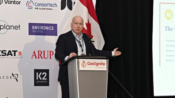
GeoIgnite 2026, Canada’s national geospatial leadership conference, was held in Ottawa from May 11 to 13. It brought together leaders from government, industry, academia, Indigenous organizations and international partners to discuss the role of geospatial capability in Canada’s infrastructure, security, sovereignty, and digital future.
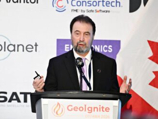
During his keynote, “The Total World Model,” Peter Rabley ended with questions he teed up for the audience. The last slide before his thank-you asked one of them outright: is the geographic substrate being defined right now without us? As he told me afterward, that was deliberate. He wanted the room to walk out thinking and discussing.
Rabley is CEO of the Open Geospatial Consortium, the standards body that governs how geospatial technology interoperates and data moves between systems, agencies, and countries. His keynote, “The Total World Model,” argued that geography does not belong at the edge of artificial intelligence, reduced to a tool applied after the fact. It belongs in the reasoning substrate itself — the foundational layer any AI world model needs to understand physical reality.
This piece comes from a follow-up conversation with Rabley after GeoIgnite, built around the questions he left with the room: what geography is, what it takes to trust what AI produces from it, and how much time Canada has to decide both for itself.
What geography is
I put it to Rabley that he is repositioning the discipline, and he corrects the premise. “I would not call it a repositioning. I would call it a restoration.”
Geography is over two thousand years old. Ptolemy defined it in the second century as “a representation in pictures of the whole known world together with the phenomena which are contained therein,” and that definition has held. What changed in 1961, when Roger Tomlinson met Lee Pratt at the Canadian Land Inventory, is that the cartographer’s discipline became machine-actionable. And in 1994, the map user became almost everyone. Neither shift, in Rabley’s account, altered the mission. What shifted is that geography was allowed to dissolve into the social sciences, while GIS — a toolset — was reframed as the discipline. He notes that the world’s largest GIS company describes its mission as “advancing the power of geography.”
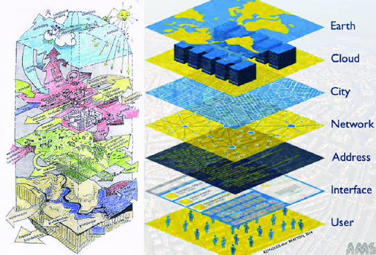
If the next inflection point in AI is the world model, as he argued at GeoIgnite, then the substrate of that model is the world described in three dimensions, with semantics, with provenance, over time. “That is geography by another name,” he says.
Technically, Rabley says this world model needs three things the frontier AI companies have not built, and this industry has spent thirty years building: open spatial standards covering geography, semantics, and conformance; integrity, provenance, and trust at machine-readable resolution; and APIs, not files, as the primary engagement layer.
Institutionally, he wants geography back in the curriculum as the integrative discipline it has always been, not as a GIS option within a computer science department. He wants the profession to stop fighting to be classified as a vertical inside national occupational schemes and to start being credentialed inside every discipline that touches physical systems. And he wants geospatial expertise in the room when AI regulation is being drafted, not just when AI is being applied.
“This is not a repositioning of geography. It is the return of a discipline that should never have been reduced to a toolset.”
That argument carries straight into the critique he aimed at his own audience: stop prefixing everything with “geo.”
Geo-AI, geo-cloud, geo-this, geo-that. Rabley calls the habit a symptom. The cause is that the field still thinks of itself as a single vertical industry when it is a horizontal layer underneath every vertical that touches physical reality. That is its real strength, and why it is hard to see, hard to explain, and easy to underbudget. “The hidden substrate is, by definition, hidden.”
He points to a live example in Canada: a coalition of community colleges and a major GIS vendor working to update the federal occupational classification system to better codify titles like “GIS analyst” and “UAV operator.” He calls it competent work that will probably succeed. It also accepts the premise that geospatial is a vertical that needs better internal labeling at exactly the moment the underlying work is dissolving into every discipline that touches AI, infrastructure, and physical systems. “The category is being formalized as it dissolves.”
His test for any modernization effort: “Are you re-describing the boundary of an existing category? Or are you making the underlying geographic literacy a horizontal requirement across every discipline that needs it? The first preserves the silo by giving it a nicer label. The second is what the world is going to pay for”, he says.
The adjustment he is asking for has a forty-year-old precedent. The Province of Flevoland in the Netherlands moved geoinformation out of the IT department and embedded it in the policy directorate, treating spatial analysis as the key integrator of water, land, transport, agriculture, and energy. Forty years on, that function runs digital twins, AI-assisted classification, and scenario modeling. The institutional adjustment was made first, and the outcomes followed.
Asked how far he takes the argument: “All the way. Stop relabeling. Stop prefixing. Stop accepting that GIS is the category. Move the practice to where it does the work. If we label back to the silo, we fall further into obscurity. If we seize the geographic substrate the world now needs, we get to define new roles for ourselves.”
What it takes to trust what AI produces
The word Rabley used at GeoIgnite for what AI already produces comes from Will Cadell’s essay “AI ate my GIS”: adequate. A consumer-grade AI agent built a working least-cost path on a map, sourced the open data, and applied the attributes — typically six weeks of work for a specialist GIS team, completed in less than a day, without touching traditional GIS technology or any explicit geospatial expertise. Cadell’s warning is that adequate might be good enough.
I asked Rabley whether the profession’s insistence on precision is becoming a barrier to relevance, or whether adequacy is the thing to fear. “Both. And they are the same problem from opposite ends.”
He concedes that the insistence on precision and detail has, in places, become a barrier to relevance. Ed Parsons makes the same case: brute force at scale, applied to enough data, will produce results good enough for most applications — applications the profession has slowed and constrained through legitimate but sometimes excessive concerns about accuracy and completeness.
The second half he treats as the more dangerous one because, at scale, what is adequate without provenance is what he and his colleague, Dr. Ingo Simonis, call a confident error at scale. “A 10% margin of error in determining when a pizza shop might close is harmless. The same margin on “which floor are the people in the burning building?” can be fatal. The same margin on whose seabed claim is recognized in the Arctic is a key sovereignty issue. Adequacy is not a property of the data. It is a property of the use.”
And it is happening at an unprecedented scale, with unprecedented amounts of compute, capital, and skilled labor being applied. Pokémon Go became one of the most detailed visual positioning systems on Earth — thirty billion images, ten years, an entire city of crowdsourced sensors — without ever asking the geospatial profession’s permission. “What I am most afraid of is not adequacy. It is unverifiable adequacy. Those are not the same thing.”
He quotes Parsons on where that leaves the industry: “To survive the coming decade, the geospatial industry must accept that its future does not lie solely in capturing reality with higher fidelity. The future belongs to those who can build the most robust, physics-aware, and dynamically predictive simulations of reality. They must evolve from being the archivists of the Earth to becoming the architects of its digital twin.”
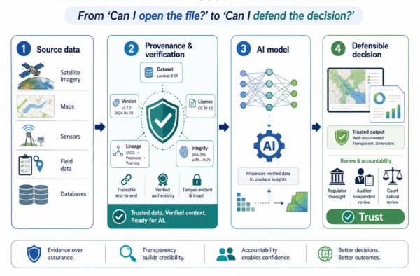
Unverifiable adequacy is what drives Rabley’s redefinition of interoperability. The old question — can I open the file; can my software read your format — is largely solved. “New interoperability asks: can I defend the decision? Can I show, to a regulator, an auditor, or a court, that the spatial reasoning behind this decision is traceable to data of known integrity and known provenance that I have a reasonable basis to trust? That question has barely begun.”
The framework is IPT — integrity, provenance, trust — which Rabley credits to Simonis and to work running through OGC’s Testbeds 19 and 20. It demands three things of standards. Machine-readable provenance at inference, not at publication: the model must be able to cite the dataset, version, license, and lineage at the time of the answer, and refuse to answer if any are missing. Cryptographic verifiability built into the spatial stack — signing, watermarking, verifiable credentials — because in a world where AI can generate plausible spatial data, the line between authentic and synthetic must be verifiable by machines. And IPT is moving from a voluntary best practice to a default expectation. “Optional provenance is no provenance.”
“The shift from ‘can I open the file’ to ‘can I defend the decision’ is not a software upgrade. It is a governance upgrade, delivered through standards.”
The same logic runs into the question he left the room to think about: what should open data mean for Canada?
His answer is a notion he calls curated exposure. It is not in the FAIR principles. FAIR was designed in the academic research data community fifteen years ago and has held up remarkably well in terms of findability, accessibility, interoperability, and reusability. But FAIR is silent on FAIR to whom? Findable to whom? Accessible to whom? Reusable under what governance, by what authority, and with what consequences when it is wrong?
There are, in Rabley’s view, enough examples of harm caused by treating openness as an unmitigated good. The Satellite Sentinel Project — the Harvard Humanitarian Initiative’s eighteen-month effort to monitor mass atrocities along the Sudan–South Sudan border using high-resolution satellite imagery — had to continuously weigh the consequences of publicizing images of vulnerable populations when the audience included the parties to the conflict themselves. Infrastructure that was acceptable as open data in 2010 — railway lines, energy substations, water-treatment topology — now has real strategic and national-security implications. “The data did not change. The world changed around it.”
The pattern is not confined to conflict zones. The U.S. Department of the Interior’s Federal Indian Boarding School Initiative identified 74 marked or unmarked burial sites of Indigenous children at 65 former federal boarding schools and withheld the specific locations to protect the sites from grave robbing and desecration. The U.S. Geological Survey withholds the nature and location of sensitive archaeological and cultural resources under federal statute. These are instances of curated exposure already operating within federal data practice — ad hoc, site-by-site, with no general framework. The intellectual frame is the one in Canada’s OCAP® and CARE principles: the data-subject community decides who knows what, when, and for what purpose.
“Curated exposure is the alternative. Open where it serves the public interest. Calibrated where it does not. Contracted access for sensitive layers. Verifiable identity for high-risk queries. Versioned, auditable, revocable.”
Canada, he argues, already holds the working model. The Pan-Canadian Geospatial Strategy embeds OCAP and CARE for Indigenous data sovereignty — a framework he calls best-in-class globally. His suggestion is to extend the discipline of that frame conceptually to other categories of sensitive spatial data: sovereign infrastructure, Arctic seabed, and dual-use layers.
“Open by default was the right answer for the second wave of open data. For the third wave — under AI, with adversarial actors, in geopolitically volatile periods — open-by-default is no longer openness. It is exposure. We do not need a repeat of Sudan.”
How much time does Canada have?
The keynote’s most specific claim gave Canada eighteen to twenty-four months to set its own terms before they are set for it. Asked who is running out of time, Rabley named three sectors, “and I am not sure they are fully aware.”
The first is the federal apparatus. The Pan-Canadian Geospatial Strategy implements from 2026 to 2031 — a five-year horizon against a technology cadence closer to twelve months. At the present pace, by 2031, Canada will be executing 2025’s assumption. His prescription is eighteen-month implementation sprints with explicit re-baselining at the end of each cycle, “or it ages out faster than it ships.”
The second is the profession. Canada is aligning its AI regulatory posture more closely with the EU. Those rules are being drafted now, and geospatial professionals are largely not in those rooms. Where they are, Rabley does not think the case has yet been made that spatial reasoning is a foundational substrate of AI rather than an application of it. “When that case is not made, it will get made for us.”
The third is the geospatial industry, Canadian and global. The frontier AI infrastructure stack is being verticalized rapidly. NVIDIA’s physical AI stack across Cosmos, Isaac, GR00T, Omniverse, and Jetson Thor is the most visible example. The geospatial industry is not seen as a provider of reasoning substrates. “That is not a failure on their part to address. It is one of ours, and the time to address it is running out.” He suggests that the INSPIRE program in Europe — fourteen years of standards work and not enough money to operationalize them — is a good example of making something of contractual rather than infrastructural value.
The financing gap is already on the record. The Canada Strategy’s own stock-take scored financing at 17.8 out of 100, its lowest pillar — a gap Sumit Gera acknowledged when GoGeomatics reported on the strategy earlier this year.
What comes next
The keynote ended where this interview began, on a question Rabley wanted us to think about: is the geographic substrate being defined right now without us? The Pan-Canadian Geospatial Strategy has committed to a five-year horizon. Rabley suggests we have eighteen to twenty-four months. He left it to the room to decide what Canada should afford.

Be the first to comment