
Highlights
There is a tendency to use aerial photographs and digital images as the cartographic product!
These pictures are the primary mapping data. And require a transformation from its conic into an orthographic projection. The transformation is achieved through techniques of Land Survey, GPS, Photogrammetry and CAD software. Also, overlapping pictures and stereovision are crucial to accomplish the final-desired map(s).
Mapping has entered the drone era
A 2.5 minutes video to illustrate the theoretical content of this article.
https://www.youtube.com/watch?v=J7NRVPNaxtU ~ 2.5 minutes video
Stereovision and stereo-model orientations.
Artificial stereovision – overlapping pictures taken from different points of view are observed through a device that allows each eye to see the details individually. Therefore, and similarly to the natural stereovision, the brain receives the impression of the object from two different perspectives and generate the 3D vision.
Stereo-model orientations are the procedures to; 1st) reconstruct the position of each image at the moment of exposure, by stereo-viewing terrain features on the overlapping pictures. 2nd) the stereo-model is Geo-referenced to the Earth surface by ground control points and/or GPS.
Geo-referencing
The GPS methods
Real-Time Kinematic (RTK), to be most effective, an Inertial Measuring Unit (IMU) should be also used to record the attitude of the aircraft (yaw, pitch, roll) at the time of exposure of the picture;
Post-Processing Kinematic (PPK), has the advantage of using the dual-GPS-frequencies. Hence, minimizing the risk of GPS-errors-propagation such as; satellite geometry, clock inaccuracies, Ionospheric and Tropospheric delays, and multi-path.
Ground Control Points
GCPs are points Geodetically known by its coordinates E, N, H. They must be well identifiable in the terrain and on the pictures. Usually, they are set on terrain-features or as pre-marked (target) locations. GCPs should also be used as check-points to verify the reliability and accuracy of the required final products.
The Photogrammetric method
Comprise an Aerial-Triangulation (AT) measurements and a Bundle Block Adjustment.
Auto measurements by image-matching using software that identifies similar features on the images have replaced human measurements. The method became known as Automated-AT (AAT). A Bundle Adjustment is a sophisticated algorithm to perform the calculation and best fit of the AT measured points onto the GCPs and GPS points. Also, the algorithm should be capable to compute and compensate for miss-calibration of the camera parameters; for GPS-slips & antenna off-set from the camera principal point; for Ionospheric, Tropospheric and Atmospheric delays; for detection and elimination of AT measuring errors (outliers). Usually, the bundle block adjustment software does the computation and compensation for Earth curvature. However, this is not a common case with UAS imagery due to the small size of the projects.
Drone Aerial Mapping
A 5 minutes video to illustrate how to make the data capture, process and application of a UAS imagery mapping project, https://www.youtube.com/watch?v=UXVH8er9LTE
Businesswise and Education-wise
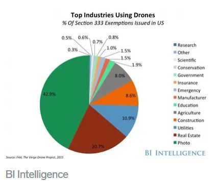
The drone business continues booming and creating new opportunities. The biggest players requiring this type of service are sampled in the following graph. As well as, a sample of charges currently practiced by the professionals providing these services.
The hourly rate for a professional drone pilot expanded with mapping expertise certification vary according to the industry which requires the service as follows:
| Industry | Acceptable charge |
| Energy, Mining, Land Surveying | $195 |
| Agriculture, Construction, Real estate | $160 to $170 |
The average hourly charge is $150 with a minimum of $100 and a maximum of $200.
Geomatics
https://www.youtube.com/watch?v=E_vzYQCjp7g ~ 2 minutes video
https://www.youtube.com/watch?v=OoC2MZt813o ~ 1.5 minute video
https://www.youtube.com/watch?v=vuh9OX2E6ek ~ 2.5 minutes video
Agriculture
https://www.youtube.com/watch?v=msYQLbyIlng ~ 5.2 minutes video
Oil & Gas ~ 8 minutes video
https://www.youtube.com/watch?v=TLa1NtRBEeE ~ 8.2 minutes video
Education ~ 12 minutes video
BCIT to Antarctica, 3-D Mapping with Drones – Eric Saczuk
https://www.youtube.com/watch?v=cwITLVGbVlQ&feature=emb_rel_end ~ 21.2 minutes


Be the first to comment