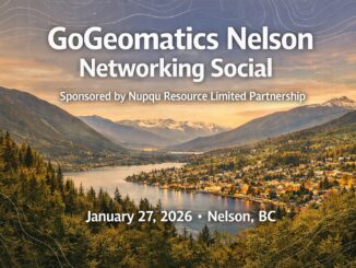
• facebook
  • Twitter
  • Linkedin
  • Youtube
  • Linkedin Group
  • Post a Job
  • Post an Ad
  • Post an Event
  • Post a Directory Listing
  • Post a Press Release
  • Media Kit
  • My Account
  • Login
GoGeomatics
  • MAGAZINE
    • BIM & GIS
    • Community
    • Conference news
    • Earth Observation
    • Education & Careers
    • GEOAI
    • Announcements
    • Reality Capture & Lidar
    • Science
    • Technology
  • Directories
    • ASSOCIATION
    • INDUSTRY
    • EDUCATION
    • Open Data
  • EVENTS
    • GeoIgnite Events
    • Events Calendar
    • GoGeomatics Meetups
  • Services
    • Advertising
    • Marketing
    • Post a Job
    • Post an Ad
    • Post an Event
    • Post a Press Release
    • Post a Directory Listing
    • Media Kit
    • Web Design
  • Find a Job
  • Volunteer
    • Start a GoGeomatics Group
    • Editors & Writers Group
  • About Us
    • About Us
    • Contact Us
    • Frequently Asked Questions
  • Videos
HomeCommunity

Community

Entete-JMap Cloud
BIM & GIS

JMap Cloud – A Homegrown Solution in an Uncertain Time

28 October 2025 David Legris | api

We have spent much of the last year at GoGeomatics discussing data sovereignty and its impact on our professional and personal lives. Modelled after the idea of national sovereignty, data sovereignty dictates that ownership and […]

Community

“Bot Ad” Ethics and Land Surveying

24 October 2025 Gavin Schrock | Ad Bots

It was only a matter of time until bot-triggered online advertising infiltrated the surveying profession. While it could be argued that it is just another marketing tool, there are approaches that walk a thin ethical—and […]

BIM & GIS

From the C-Suite: Navigating the Future of Canada’s Geomatics Sector

23 October 2025 GoGeomatics Canada | AI and Geospatial

Canada’s geomatics sector is standing at a crossroads. With the federal government committing 5% of GDP to defence,  including 1.5% for critical infrastructure, the country is entering a genuine nation-building moment. New investments are set […]

education
BIM & GIS

Education Takes Centre Stage at GoGeomatics Expo 2025

22 October 2025 GoGeomatics Canada | academic-industry collaboration

Every generation reaches a moment when it must ask: Who will build what comes next? For Canada’s geomatics community, that moment is now. As infrastructure ambitions expand and technology evolves faster than curricula, the gap […]

BIM & GIS

3D Mapping Transforms Smoke Monitoring

22 October 2025 Alefiya Dungrawala | 2D mapping

Wildfires across North America are no longer confined to a single season. Each year, they burn longer, spread faster, and shatter new records. Satellites have helped scientists track their movement and map the destruction in […]

Community

28th Annual Geomatics Exposition at the University of Calgary

21 October 2025 GoGeomatics Canada | #GeomaticsCommunity

Calgary, AB  October 2025 – The Geomatics Engineering Student Society (GESS) at the University of Calgary is proud to announce the upcoming 28th Annual Geomatics Exposition (Geo Expo 2026), scheduled for Thursday, February 5, 2026. […]

Why attend?
BIM & GIS

10 Reasons to Attend and Support GoGeomatis Expo in Calgary

20 October 2025 GoGeomatics Canada | AI

The GoGeomatics Expo in Calgary, happening November 3-5, 2025 isn’t just another industry event — it’s a national gathering that connects technology, policy, and community in ways no other event does. Here are 10 reasons to […]

Community

NRCan’s e-Bulletin Highlights WildFireSat Progress

17 October 2025 David Legris | Arctic Development Expo

Natural Resources Canada has unveiled the WildFireSat e-Bulletin, a new periodic update that highlights developments in Canada’s satellite mission dedicated to monitoring wildland fires. WildFireSat is poised to become the world’s first purpose-built operational satellite […]

Posts pagination

« 1 2 3 4 … 129 »

Events

Feb 24
February 24, 2026 - February 26, 2026

Government Innovation Week – Federal

Feb 24
February 24, 2026 @ 10:00 am - February 25, 2026 @ 4:00 pm

Lidar CANEX 2026

Feb 25
All day

Government Cybersecurity Showcase Federal 2026

Mar 1
March 1, 2026 - March 4, 2026

PDAC Convention 2026

Mar 10
March 10, 2026 - March 13, 2026

2026 ABCLS Conference and 121st Annual General Meeting

View Calendar

View All Events

Services

  • Post a Job
  • Post an Ad
  • Post an Event
  • Post a Directory Listing
  • Post a Press Release
  • Media Kit
  • My Account
  • Login

Jobs

Post a Job
  • Canada Maps and Poster Gallery Volunteer Leads — GeoIgnite 2026
    remote
  • GIS & Data Analytics Lead
    Beaumont, AB
  • Lead Surveyor, Projects/Arpenteur-géomètre principal, projets; arpenteuse-géomètre principale, projets
    North Bay, Thunder Bay
  • Senior GIS Developer
    Calgary, AB
View All Jobs
  • Directories
    • Associations Directory
    • Industry Directory
    • Education Programs
    • Open Data
  • Volunteer
    • Start a GoGeomatics Group
    • Editors & Writers Group
  • About Us
    • GoGeomatics Media Kit
    • Who We Are
    • Contact Us
    • FAQ’s
    • Advertising
    • Marketing
  • Subscribe
GoGeomatics
GoGeomatics is the largest and most popular communications hub promoting the Canadian geospatial community. The business was incorporated in 2011. GoGeomatics hosts over 100 fun, free, location technology networking events each year in cities across Canada.

© 2025 GoGeomatics

  • facebook
  • Twitter
  • Linkedin
  • Youtube
  • Linkedin Group