• facebook
  • Twitter
  • Linkedin
  • Youtube
  • Linkedin Group
  • Post a Job
  • Post an Ad
  • Post an Event
  • Post a Directory Listing
  • Post a Press Release
  • Media Kit
  • My Account
  • Login
GoGeomatics
  • MAGAZINE
    • BIM & GIS
    • Community
    • Conference news
    • Earth Observation
    • Education & Careers
    • GEOAI
    • Announcements
    • Reality Capture & Lidar
    • Science
    • Technology
    • Between the Poles
  • Directories
    • ASSOCIATION
    • INDUSTRY
    • EDUCATION
    • Open Data
  • EVENTS
    • GeoIgnite Events
    • Events Calendar
    • GoGeomatics Meetups
  • Services
    • Advertising
    • Marketing
    • Post a Job
    • Post an Ad
    • Post an Event
    • Post a Press Release
    • Post a Directory Listing
    • Media Kit
    • Web Design
  • Find a Job
  • Volunteer
    • Start a GoGeomatics Group
    • Editors & Writers Group
  • About Us
    • About Us
    • Contact Us
    • Frequently Asked Questions
  • Videos
HomeTechnology

Technology

Technology

CANADA’S NATIONAL ELEVATION DATA STRATEGY UPDATE NOVEMBER 2023

18 December 2023 David Belanger | airborne topo-bathymetric

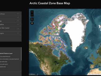
Fall 2023 LIDAR ACQUISITIONS 2023 IN SUPPORT OF THE FLOOD HAZARD IDENTIFICATION AND MAPPING PROGRAM (FHIMP) Since 2021, Natural Resources Canada (NRCan) has been leading the Flood Hazard Identification and Mapping Program (FHIMP) in partnership […]

Community

Land Survey Project Management Software: Cyanic Job Book

14 December 2023 Michael Heath | Archaeology GIS

Land Surveying Management Software The GoGeomatics workshop on November 7, 2023, led by industry veteran and Cyanic Automation founder Doug Kondor, offered insights into project management specifically tailored for the surveying and geospatial industry. The […]

Technology

The Power of Integrating Esri Tools with Leading SaaS Environments

12 December 2023 Farzaneh Farshad | ArcGIS

In the dynamic landscape of technology, the integration of robust tools becomes a pivotal factor in driving innovation and efficiency across various industries. One noteworthy development is the strategic collaboration between Esri, a global leader […]

Technology

CHORUS – A Next-Generation Earth Observation Constellation to Tackle Our Planet’s Biggest Challenges

12 December 2023 MDA | Archaeology GIS

Access to space-based information, in near real-time, about both natural and human-caused disasters, including earthquakes, hurricanes, oil spills and flooding, provides decision-makers with actionable insights to address some of the world’s most pressing challenges. CHORUS, […]

Technology

Canadian Geospatial Digest December 11, 2023

11 December 2023 Volunteer Editors and Group Writers | Aerial technology

The wildfire-fighting drones of the future. Restoring salmon habitat: An interactive map The maps selected for the 2024 Esri Canada Map Calendar Autonomous plant stand counting with Croptomistic Visualizing climate change in the Canadian Arctic […]

Technology

Download GNSS Base Data Sooner Rather Than Later

4 December 2023 Gavin Schrock | #assetmapping

Whether it is for mobile mapping, drone work, asset mapping or surveying static campaigns, taking steps early in the process a confirm the availability, completeness, and quality of the base files you intend to use […]

Technology

International Geospatial Digest December 4th, 2023

4 December 2023 Volunteer Editors and Group Writers | ArcGIS

ArcGIS GeoBIM proves critical for Peruvian megaprojects Taylor Geospatial Institute increases hiring Growing the Australian geospatial industry Mapping USA’s food sources Jharkhand’s tribal development digital atlas ESRI’s new integrations ArcGIS GeoBIM proves critical for Peruvian […]

Technology

From Flames to Data: How deep learning can help in wildfire suppression?

28 November 2023 Alefiya Dungrawala | 2023 wildfire season

We are driven by our survival tendency. And that compels us to know or be able to predict the future. From looking into the crystal ball and predicting the future to locating stars and their […]

Posts pagination

« 1 … 45 46 47 … 144 »

Events

Notice
There are no upcoming events.

View All Events

Services

  • Post a Job
  • Post an Ad
  • Post an Event
  • Post a Directory Listing
  • Post a Press Release
  • Media Kit
  • My Account
  • Login

Jobs

Post a Job
  • GIS Technologist II
    Fernie, B.C.
  • GIS I TECHNOLOGIST
    Fernie, B.C.
  • Operations Spatial Data Assistant (Contract)
    Vaughan
  • GIS Analyst
    Saint John, New Brunswick
View All Jobs
  • Directories
    • Associations Directory
    • Industry Directory
    • Education Programs
    • Open Data
  • Volunteer
    • Start a GoGeomatics Group
    • Editors & Writers Group
  • About Us
    • GoGeomatics Media Kit
    • Who We Are
    • Contact Us
    • FAQ’s
    • Advertising
    • Marketing
  • Subscribe
GoGeomatics
GoGeomatics is the largest and most popular communications hub promoting the Canadian geospatial community. The business was incorporated in 2011. GoGeomatics hosts over 100 fun, free, location technology networking events each year in cities across Canada.

© 2026 GoGeomatics

  • facebook
  • Twitter
  • Linkedin
  • Youtube
  • Linkedin Group