The spatial reference system is the skeletal structure of the geospatial industry. They serve as a driving force for various industries, which heavily rely on spatial data.
It is the oldest and most accurate method of measuring locations on the earth’s surface. The oldest geographic coordinate system dates to the Hellenistic era, when people weren’t even sure if the Earth was flat.
It’s astonishing how far humanity evolved. Our understanding of the earth, like our evolution from ancient to modern reference systems, is an ongoing venture. As we gain a new perspective on our ever-changing reality, new systems take their place.
Similarly, by 2025, the older national spatial reference system will be fully upgraded to the New National Reference System (NSRS) and the North American Terrestrial Reference Frame (NATRF2022).
New National Spatial Reference System
The National Geodetic Survey (NGS), a part of the National Oceanic and Atmospheric Administration (NOAA), is now attempting to improve the National Spatial Reference System. The upgrade is based on improved knowledge of changing earth geography and spatial data of a new and transformed world.

When I say a New National Spatial Reference System (NSRS) is being built and will soon enter the lives of the geospatial world, I mean a tremendous continuing endeavor is taking place to streamline the current spatial reference.
Geographical data such as latitude, longitude, shoreline position, elevation, and gravity have changed over time due to changes in and on the earth and its terrain. However, anticipating this upcoming change, it is instinctual to have questions such as whys and whats.
Keeping that in mind, I’d want to address what’s changing and why.
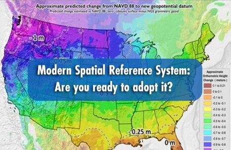
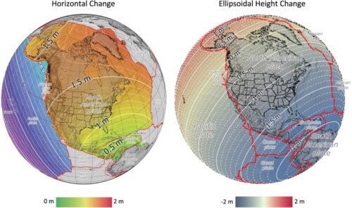
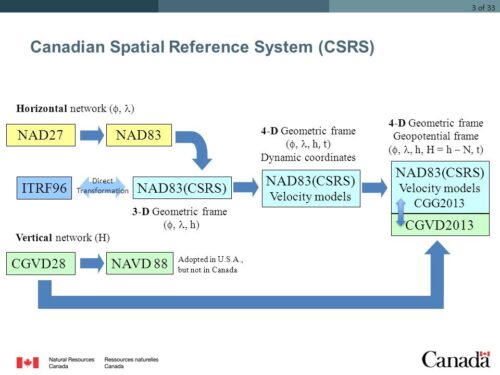
We have become fairly adept at using our current reference systems, NAD83 and NAD88, which are the horizontal and vertical datums. The new reference system is going to bring them together, making the dimensions operate together in given time. The primary reason for the change in coordinates from NAD83 to NATRF2022 is a 2.2 m shift between the NAD83 and NATRF2022 origins at the Earth’s center of mass. Along the U.S.-Canada border, the horizontal coordinate difference between these two systems will vary from 1.3 to 1.5 m.
So, why do we need a new one?
Integration would not work well for NAD 83 and NAVD 88, due to their systematic inaccuracies with current spatial data. This discrepancy is the outcome of outdated orthometric data, particularly through modifications and assumptions that there is no change in the terrain and geographically changed data of the earth. It would rather be unrealistic to assume that nothing has changed on Earth since the last set of data was captured.
Over time, whether in the short or long term, erroneous data will begin to impact positional accuracy more as the offset keeps on getting wider. However, there are no negative repercussions to using the present datum. Legacy datums are still in use.
What data do we have, and what do we need?
We have the previous ground-based data, as well as the satellite data, which are decades old. What we required was data collected between space and earth, or ‘airborne gravimetry’ from the middle portion of the atmosphere. Airborne gravimetry is a well-proven, and advanced method of measuring the earth’s gravity from a moving aircraft. The gravity data collected like this will be fed to a geoid model that is highly reliant on gravity data.
Interestingly, GPS ellipsoid heights and a new gravimetric geoid model are in fact two main factors that are shaping the new reference system, calling it GEOID2022.
Impacts and preparedness
“The first step toward change is awareness, and the second step is acceptance.”
This is not an instant transformation, but an complex process of bringing change to the current reference system. It has been occurring for more than a decade, and been monitored by various industries and specialists.
This upgrade will have a wide-ranging impact on different sectors. Accepting this change and managing interoperability is the key. Early knowledge and communication to professionals to explore the impact and rewards is critical to implementing this transformation.
Promoting success stories of an NSRS adoption and its advantages. This is one of the methods for spreading the message across numerous working groups.
Forums for discussing NSRS, reference frames, geoid models, projects, and coordinate transformations would be an excellent way to bring professionals together to discuss and resolve the issue. Along with the long-term benefits, NSRS would introduce anomalies in the system during implementation.
Talking about challenges, current applications and file formats may not support time-dependent coordinates and break down. Addressing these changes ahead of time will allow organizations that rely on spatial data to move more quickly before their systems fail.
The biggest task is making this transformation as seamless as possible.
How is it going to affect Canada?
Canada and the United States have shared a common geometric reference frame for over a century. To Summarize, the impact of this modernization, we need another article. Tools, database, product that uses old reference system will have to switch to the new one.

For this reason, the Canadian Geodetic Survey (CGS) intends to implement NATRF 2022 in 2025, concurrently with the United States. With the aim of achieving a single reference system for all of Canada, CGS is collaborating with the provinces via the Canadian Geodetic Reference System Committee (CGRSC), a federal-provincial government committee, to assist their transition to NATRF2022.
The United States intends to replace its vertical, leveling-based datum, NAVD 88, with the North American-Pacific Geopotential Datum of 2022 (NAPGD2022), which is geoid-based and thus more efficient for use with GNSS. NAPGD2022 is equivalent to Canada’s CGVD2013.3. As the US modernizes, Canada and the US will adopt similar elevation schemes.

When NATRF2022 is adopted in the US, the Canadian Geodetic Survey will provide coordinates in both NAD83 (CSRS) and NATRF2022, as well as transformation parameters and tools for transitioning between the two standards.
By 2025, transformation tools will be optimized to support NATRF2022, CGVD2013 (GEOID2022), and the updated national deformation model (IFDM2022).
Additionally, CSRS-PPP, the Canadian Geodetic Survey’s positioning service, will provide results in NATRF2022.
Many questions remain unanswered, though. They can only be answered once the new system is put into action. Although it is costly and powerful, it will ultimately help us.
References:
https://natural-resources.canada.ca/sites/nrcan/files/mapstoolspublications/NATRF2022_reference_pamphlet.pdf
https://cgrsc.ca/wp-content/uploads/2023/12/ACLS_Webinar-CSRS-Modernization-EN.pdf
https://www.geoweeknews.com/news/modernization-nsrs-surveying-datums-ngs-spatial-reference-system
https://www.geoweeknews.com/news/national-spatial-reference-system-ngs-gcap-oregon-state-gnss-satellite-positioning-
https://www.ngs.noaa.gov/INFO/OnePagers/NSRSOnePager.pdf
https://www.geoweeknews.com/news/ngs-surveying-national-spatial-reference-system-modernization-oregon-state
https://en.wikipedia.org/wiki/Spatial_reference_system
https://www.fgdc.gov/ngac/meetings/april-2024/national-spatial-reference-system-ngac-apr-2024.pdf
https://natural-resources.canada.ca/maps-tools-and-publications/geodetic-reference-systems/height-reference-system-modernization/9054


Be the first to comment