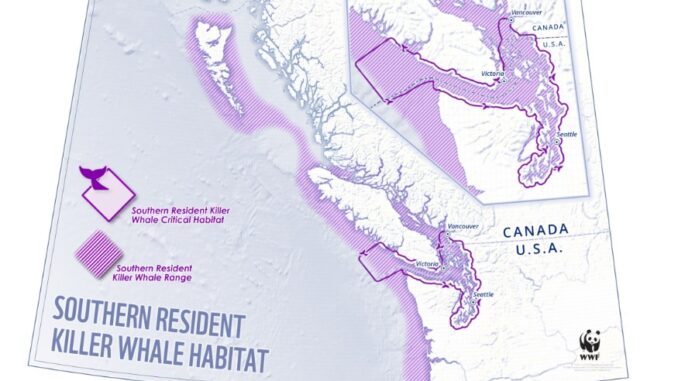
Did you know that the Southern Resident Killer Whale, often known as ‘Orca,’ is recognized as an endangered species in Canada and the United States? Killer whales spend most of their summer and fall in the Salish Sea and southwest British Columbia, whereas during the spring and winter, they travel from the north Pacific Ocean to northern California. Killer whales are only found on the Pacific coast.

Their population is under immediate threat from climate change, pollution, reduced prey availability and increased human activities like overkill and vessel noise. As a matter of fact, the number of missing or dead orcas outweighs the number of new calves welcomed to the sea. The declining whale population is alarming.
How to Save Orcas?
Orcas have important cultural significance for Indigenous communities. They have lived together for at least 5000 years. These majestic animals have been under constant strain to navigate the changing world around them. This changing landscape is sometimes life-threatening either to them or their prey.
Canada has laws and regulations in place designed to tackle these risks and support the survival of this species. Effective protection and rehabilitation of Southern Resident killer whales necessitates a long-term collaborative effort from First Nations, stakeholders, the Indigenous Multi-Nation Group, the Indigenous and Multi-Stakeholder Advisory Group, Technical Working Groups, and public consultations. Maps are the most feasible way to demonstrate strategies.
Overview Map
The map below offers a summary of four regions to help in the protection and restoration of Southern Resident Killer Whales: the Southern Gulf Islands, the Mouth of Fraser, Juan de Fuca, and Swiftsure Bank.

Each white block pointing to a color-coded location on the map contains information about that region. It provides a concise overview of rules and regulations for a certain time of year. No recreational or commercial salmon fishing, speed limits, and no boating or fishing, to name a few.
Juan de Fuca
Chinook salmon, whose populations have declined significantly over recent years, are an important source of food for Southern Resident killer whales. Fishery management’s initiatives aim to support and increase the availability of salmon in significant whale feeding sites. Juan de Fuca close to Vancouver Island, is divided into yellow and gray blocks.

The map’s grey area represents the traffic separation plan, whereas the yellow block represents a salmon fishing restriction. Special measures are put in place to separate vessel traffic.
Mouth of Fraser

A similar measure like Juan de Fuca is applied at the mouth of Fraser, as shown in the above map.
Gulf Islands
At Gulf Islands, there will be no vessels or fishing (with some exclusions) in the Interim Sanctuary , and no fishing and boating in effect in the red zone. Salmon fishing is prohibited at some coordinates. The legend in the map concisely indicates the regulations.

Also, vessel speed limited to no more than 10 knots (with some exceptions) in the Speed Restricted Zones indicated by multi lined blue zone.
SwiftSure

At swiftsure bank, coastal rockfish in RCAs are protected against early mortality caused by recreational and commercial fishing. (RCAs) are established throughout the BC coast indicated by purple border.
Salmon fishing is prohibited both recreationally and commercially throughout the yellow block. Hook & line closure in the blue-bordered section, with speed limits shown in multi lined green blocks known as Speed Restricted Zone.
Contaminants in Water
Contaminants in the water have increased significantly, thereby requiring constant monitoring and testing. Contaminated locations pose a significant hazard to the well-being of orcas. In order to tackle this pollution problem, the Canadian government has continuously strengthened the regulations and their enforcement. It has boosted the research and monitoring to understand the origins of contaminants, their quantities, and how they can be harmful to whales.

For this reason, Pollutants Affecting Whales and their Prey Inventory Tool (PAWPIT), an interactive pollutant mapping tool, is available. The tool displays estimates of pollution emissions from all recognized sources over a spatial extent that includes the habitats of Northern and Southern Resident killer whales, as well as freshwater areas vital to Chinook salmon. The map also shows the estimated overall pollutant concentrations in the Fraser River Basin, where environmental quality limits were violated, and the locations of untreated contaminated sites.
With just 73 orcas remaining in the world, by disturbing their natural habitat, we are putting these magnificent creatures at risk for survival. Whales and marine mammals can still be enjoyed, but from a safe distance.


Be the first to comment