• facebook
  • Twitter
  • Linkedin
  • Youtube
  • Linkedin Group
  • Post a Job
  • Post an Ad
  • Post an Event
  • Post a Directory Listing
  • Post a Press Release
  • Media Kit
  • My Account
  • Login
GoGeomatics
  • MAGAZINE
    • BIM & GIS
    • Community
    • Conference news
    • Earth Observation
    • Education & Careers
    • GEOAI
    • Announcements
    • Reality Capture & Lidar
    • Science
    • Technology
  • Directories
    • ASSOCIATION
    • INDUSTRY
    • EDUCATION
    • Open Data
  • EVENTS
    • GeoIgnite Events
    • Events Calendar
    • GoGeomatics Meetups
  • Services
    • Advertising
    • Marketing
    • Post a Job
    • Post an Ad
    • Post an Event
    • Post a Press Release
    • Post a Directory Listing
    • Media Kit
    • Web Design
  • Find a Job
  • Volunteer
    • Start a GoGeomatics Group
    • Editors & Writers Group
  • About Us
    • About Us
    • Contact Us
    • Frequently Asked Questions
  • Videos
Homeagriculture

agriculture

No Picture
Community

Top Ten Climate Change Maps and GIS Applications

7 March 2017 Priscilla Ancinelli | agriculture

Awareness for climate change has been steadily increasing ever since the Green Revolution in the 1960s. There is a plethora of data, maps, and Geographic Information Systems (GIS) applications available freely or accessible to the […]

Community

The 5 most interesting things that happened in geomatics in 2016

21 December 2016 Florin-Daniel Cioloboc | 2016

Let’s take a step back and have a look at what happened this year. To be honest, it was pretty hard selection. There are way too many things happening at this point around the world. […]

|||
Technology

Operational Use of Remotely Piloted Aircraft System (RPAS) for Geomatics Applications

2 December 2016 Sabina Zaidi | 2017

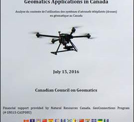
Recently, I reviewed a report by the Canadian Council of Geomatics on the use of Remotely Piloted Aircraft Systems (RPAS) for geomatics applications here at home. It was based on a study led by NWT […]

|||
Technology

Predicting the Future of the GIS in Canada

1 December 2016 Gordon Plunkett | 2015

Editors note: This article has been jointly written by Bruce McCormack and Gordon Plunkett. Bios can be found at the bottom of the article. Most people like to predict the future. People are interested in […]

No Picture
Education & Careers

Fall Reading in Canada: landscape, language, geography

29 September 2016 Robert Maher | 2016

Last week, I picked up a copy of Robert MacFarlane’s ‘Landmarks’. I had read all of his previous works and seen reviews of ‘Landmarks’ online from the UK. MacFarlane’s book got me thinking about community […]

Newsmakers & Press Releases

PCI Geomatics and PrecisionHawk Enter into Long Term Partnership

29 September 2016 GoGeomatics Newsmakers | Acquisition

PCI Geomatics, a world leading developer of remote sensing and photogrammetric software and systems, announced today it has entered into a long term partnership with PrecisionHawk, a leader in the commercial Unmanned Aerial Systems (UAS) […]

No Picture
Newsmakers & Press Releases

MDA signs contracts for RADARSAT-2 information

24 August 2016 GoGeomatics Newsmakers | accuracy

Richmond, BC – MacDonald, Dettwiler and Associates Ltd. (“MDA” or the “Company”) (TSX: MDA), a global communications and information company, announced that it has signed two contract amendments totaling CA$2.75 million with two existing long-term […]

No Picture
Newsmakers & Press Releases

TECTERRA Funds $4.9 Million for Geomatics Innovation in Canada in 2015-16

2 June 2016 GoGeomatics Newsmakers | 2015

TECTERRA Inc. announced it had committed $4.9 million of funds to support the geomatics technology sector in Canada during the last fiscal year, which ended on March 31, 2016. This additional commitment brings TECTERRA’s investment […]

Posts pagination

« 1 … 4 5 6 … 13 »

Events

Notice
There are no upcoming events.

View All Events

Services

  • Post a Job
  • Post an Ad
  • Post an Event
  • Post a Directory Listing
  • Post a Press Release
  • Media Kit
  • My Account
  • Login

Jobs

Post a Job
  • Canada Maps and Poster Gallery Volunteer Leads — GeoIgnite 2026
    remote
  • GIS & Data Analytics Lead
    Beaumont, AB
  • Lead Surveyor, Projects/Arpenteur-géomètre principal, projets; arpenteuse-géomètre principale, projets
    North Bay, Thunder Bay
  • Senior GIS Developer
    Calgary, AB
View All Jobs
  • Directories
    • Associations Directory
    • Industry Directory
    • Education Programs
    • Open Data
  • Volunteer
    • Start a GoGeomatics Group
    • Editors & Writers Group
  • About Us
    • GoGeomatics Media Kit
    • Who We Are
    • Contact Us
    • FAQ’s
    • Advertising
    • Marketing
  • Subscribe
GoGeomatics
GoGeomatics is the largest and most popular communications hub promoting the Canadian geospatial community. The business was incorporated in 2011. GoGeomatics hosts over 100 fun, free, location technology networking events each year in cities across Canada.

© 2025 GoGeomatics

  • facebook
  • Twitter
  • Linkedin
  • Youtube
  • Linkedin Group