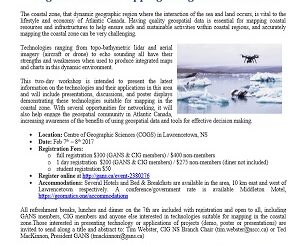
airborne
Event Recap: COGS & CIG & GANS Cooperate for Mapping Workshop
The Canadian Institute of Geomatics (CIG) Nova Scotia Branch and the Geomatics Association of Nova Scotia (GANS), two regional professional organizations that foster the application of geographic information within the geomatics sector recently collaborated to host a high resolution mapping workshop at the Centre of Geographic Sciences (COGS) in Lawrencetown, Nova Scotia.
Atlantic Canada: COGS: Geomatics Professionals Coming to Discuss High Resolution Coastal Mapping
High Resolution Coastal Zone Mapping This collaborative effort by GANS & the CIG will engage the geospatial community & increase awareness on the value…
Feb 7-8: Two Day Workshop on High Resolution Mapping Along Coastal Zones
The coastal zone, that dynamic geographic region where the interaction of the sea and land occurs, is vital to the…
UAVs in Canada – Key Exposures to Loss and Ways to Protect Yourself
This article was written by Mark Sampson for the Association of Ontario Land Surveyors. Mark’s contact details are at the…
The Canadian Institute of Geomatics (CIG) New President: Rodolphe Devillers
The Canadian Institute of Geomatics (CIG) is pleased to announce its new President, Rodolphe Devillers, PhD, Professor in Geography at…
Geoscience BC Launches Largest Airborne Magnetic Survey in its History
Vancouver, BC — Geoscience BC announced the launch of its largest airborne magnetic survey to date — the Search Phase…
Keystone Aerial Surveys, Inc. optimizes efficiency with Optech Galaxy
Teledyne Optech is pleased to announce that Keystone Aerial Surveys, Inc. has accepted delivery of the most capable airborne lidar…
Canadian Government Supports Advanced Geomatics Research
Leading Edge Geomatics will be able to develop new and advanced airborne mapping technology thanks to a repayable government contribution…
Teledyne Optech introduces low-cost, automated airborne surveying at GEOINT 2016
Teledyne Optech is pleased to announce that it will showcase its latest airborne systems including the autonomous Optech Eclipse at…
Pickett and Associates Boosts Surveying Capabilities with the Optech Galaxy
Teledyne Optech is pleased to announce that Pickett and Associates has upgraded their airborne surveying capabilities with the highly advanced…
New Autonomous Airborne Mapping Solution Redefines Industry Expectations
Teledyne Optech is pleased to announce the latest addition to its innovative line of airborne laser terrain mappers, the Optech…
2016 Student UAS Competition- Phase 1 Winners
Phase 1 of the 2016 Student UAS Competition is complete. A judging panel, comprised of Canadian subject matter experts, has…