• facebook
  • Twitter
  • Linkedin
  • Youtube
  • Linkedin Group
  • Post a Job
  • Post an Ad
  • Post an Event
  • Post a Directory Listing
  • Post a Press Release
  • Media Kit
  • My Account
  • Login
GoGeomatics
  • MAGAZINE
    • BIM & GIS
    • Community
    • Conference news
    • Earth Observation
    • Education & Careers
    • GEOAI
    • Announcements
    • Reality Capture & Lidar
    • Science
    • Technology
  • Directories
    • ASSOCIATION
    • INDUSTRY
    • EDUCATION
    • Open Data
  • EVENTS
    • GeoIgnite Events
    • Events Calendar
    • GoGeomatics Meetups
  • Services
    • Advertising
    • Marketing
    • Post a Job
    • Post an Ad
    • Post an Event
    • Post a Press Release
    • Post a Directory Listing
    • Media Kit
    • Web Design
  • Find a Job
  • Volunteer
    • Start a GoGeomatics Group
    • Editors & Writers Group
  • About Us
    • About Us
    • Contact Us
    • Frequently Asked Questions
  • Videos
Homeapplications

applications

||||||
Community

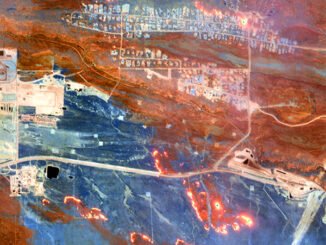
Seeing Through Wildfire Smoke in Fort McMurray, Alberta with Infrared Imaging

22 August 2016 Ben Perry | 2014

Images of the massive wildfire that engulfed Fort McMurray, Alberta earlier this year have been seared into our collective consciousness. Record-setting heat, low humidity, dry conditions and high winds combined to create a destructive “perfect […]

No Picture
Newsmakers & Press Releases

Drone Conference In Dartmouth: geoFutures – Above Between and Below

12 August 2016 GoGeomatics Newsmakers | advancement

The Geomatics Association of Nova Scotia (GANS) would like to invite you to join us at the Best Western Plus Hotel in Dartmouth on September 27th and 28th for a two day event on the future of […]

No Picture
Newsmakers & Press Releases

Open Geospatial Consortium adopts the OGC SensorThings API as an official standard

11 August 2016 GoGeomatics Newsmakers | api

The Open Geospatial Consortium (OGC®) has adopted SensorThings API Part 1: Sensing as an official standard. The OGC SensorThings API provides an open, geospatially enabled way to interconnect Internet of Things (IoT) devices, data, and […]

No Picture
Newsmakers & Press Releases

RouteMagic: A Unique Way of Mapping Your Bike Route

8 August 2016 GoGeomatics Newsmakers | android

Always at the forefront, the CycleMap application is revolutionising how people plan their bike rides with its RouteMagic, a new and unique feature that, in a matter of seconds, provides customized biking loop path, a […]

|||Cluster Map of Spatial Autocorrelation
Community

University of Victoria Hosts Advanced Spatial Analysis Course

20 July 2016 Anders Erickson | 2016

Is neighbourhood socioeconomic status associated with pediatric and childhood injuries? Are such injuries clustered in space? How can I model the spatial dependence in pediatric and childhood injuries in order to help policy makers develop […]

No Picture
Newsmakers & Press Releases

EMSA expands use of RADARSAT-2 information for maritime applications

19 July 2016 GoGeomatics Newsmakers | applications

MacDonald, Dettwiler and Associates Ltd. a global communications and information company announced that it has signed a four year contract with a ceiling of 31 million euros to provide RADARSAT-2 information to the European Maritime […]

No Picture
Newsmakers & Press Releases

Countdown to Launch: DigitalGlobe’s WorldView-4 Earth Imaging Satellite

19 July 2016 GoGeomatics Newsmakers | accuracy

Final preparations are underway at Lockheed Martin to ship DigitalGlobe’s WorldView-4 earth imaging satellite to Vandenberg Air Force Base for a Sept. 15 launch. The Lockheed Martin team is completing final satellite testing and checkout […]

No Picture
Technology

Making a Crow Attack Web Page With Open Source GIS Tools

6 July 2016 GIS Program Langara CS | 2016

Of all the pleasant events that happen in spring, crow attacks rank at the bottom of the pile. Crows become aggressive as the fledgling crows hatch, and attack anything that passes near the nest – […]

Posts pagination

« 1 … 7 8 9 … 38 »

Events

Notice
There are no upcoming events.

View All Events

Services

  • Post a Job
  • Post an Ad
  • Post an Event
  • Post a Directory Listing
  • Post a Press Release
  • Media Kit
  • My Account
  • Login

Jobs

Post a Job
  • Software Engineer – Geographic Information System (GIS)
    Ottawa, ON
  • GIS Data Quality Analyst
    Burnaby, British Columbia
  • GIS Cartographer
    Montreal, QC
  • SENIOR PLANNER SPATIAL ANALYSIS SIPA
    Toronto, ON
View All Jobs
  • Directories
    • Associations Directory
    • Industry Directory
    • Education Programs
    • Open Data
  • Volunteer
    • Start a GoGeomatics Group
    • Editors & Writers Group
  • About Us
    • GoGeomatics Media Kit
    • Who We Are
    • Contact Us
    • FAQ’s
    • Advertising
    • Marketing
  • Subscribe
GoGeomatics
GoGeomatics is the largest and most popular communications hub promoting the Canadian geospatial community. The business was incorporated in 2011. GoGeomatics hosts over 100 fun, free, location technology networking events each year in cities across Canada.

© 2025 GoGeomatics

  • facebook
  • Twitter
  • Linkedin
  • Youtube
  • Linkedin Group