Easing the Aerial-to-CAD Bottleneck
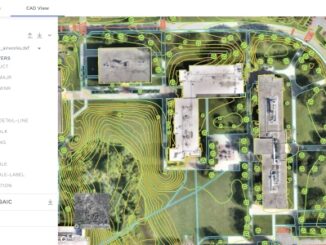
Data capture is getting easier and faster, but the subsequent step of CAD linework generation is a bottleneck, and even more so with the present shortage of qualified drafters. AI is stepping in to help. […]
Traditional pathways for creating, using, and sharing modeled 3D reality data presents challenges to broader adoption. Montreal-based Prevu3D provides a unique solution to remove those barriers. Reality capture has become easier and less expensive than […]
Ryan Hamilton & John Roos from Maxar Technologies presented their earth observation satellites and new advances in photogrammetry. They allow high levels of detail in 3D models that previously only airborne sensors could provide. […]
Continuous surveying, to support smart cities, infrastructure, geodesign, and construction, is opening expanded—but unconventional—roles for surveyors and geospatial practitioners. “Put me in coach, I’m ready to play… today…” – John Fogerty [The following guest op-ed […]