
Community
In order to determine whether geomatics is the most appropriate term for this field it may be useful to review some history. In the mid-1980s the various sub-disciplines of what is now called geomatics, consisting […]
Very Sad News for the Remote Sensing Community. / Triste nouvelle pour la communauté de télédétection. [CRSS-SCT] Canadian Remote Sensing Society / Société canadienne de télédétection Le français suit It is with the heaviest of […]
Jon Murphy knows how to ask some interesting questions – which is perhaps why I like reading what comes out from GoGeomatics. He asked me to write about missed opportunities in Canada that I have […]
First off, HAPPY GIS DAY! Twitter was having a hayday with #GISDay tweets, and LinkedIn became a geospatial frenzy. What did you do for GIS Day? GoGeomatics Canada was happy to host our second annual […]
For the first editorial for the new Canadian web magazine for geomatics I have been asked to comment on where we have been in the past, where we are today, and what the future may […]
GoGeomatics has had the pleasure of speaking with Dr. Robert ‘Bob’ Ryerson of KIM Geomatics Corporation. Along with his recently published book titled “Why ‘Where’ Matters“, Dr. Ryerson is Canada’s first PhD in Remote […]
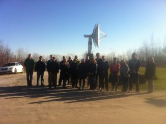
You are invited to the GoGeomatics GIS Day event – Free RADARSAT Receiving Station Tour If you would like to take the tour or know someone who might please pass this message on. Date: November […]