• facebook
  • Twitter
  • Linkedin
  • Youtube
  • Linkedin Group
  • Post a Job
  • Post an Ad
  • Post an Event
  • Post a Directory Listing
  • Post a Press Release
  • Media Kit
  • My Account
  • Login
GoGeomatics
  • MAGAZINE
    • BIM & GIS
    • Community
    • Conference news
    • Earth Observation
    • Education & Careers
    • GEOAI
    • Announcements
    • Reality Capture & Lidar
    • Science
    • Technology
  • Directories
    • ASSOCIATION
    • INDUSTRY
    • EDUCATION
    • Open Data
  • EVENTS
    • GeoIgnite Events
    • Events Calendar
    • GoGeomatics Meetups
  • Services
    • Advertising
    • Marketing
    • Post a Job
    • Post an Ad
    • Post an Event
    • Post a Press Release
    • Post a Directory Listing
    • Media Kit
    • Web Design
  • Find a Job
  • Volunteer
    • Start a GoGeomatics Group
    • Editors & Writers Group
  • About Us
    • About Us
    • Contact Us
    • Frequently Asked Questions
  • Videos
HomeCollection

Collection

No Picture
Newsmakers & Press Releases

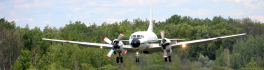
eBee becomes Canada’s first compliant fixed-wing drone

21 July 2015 GoGeomatics Newsmakers | aerial

Mapping UAV’s new designation will help operators to boost their businesses Swiss professional drone manufacturer, senseFly, today announced that its eBee has become the first fixed-wing system to be designated a ‘compliant small UAV’ by […]

No Picture
Newsmakers & Press Releases

BlackBridge to be Acquired by Planet Labs

15 July 2015 GoGeomatics Newsmakers | 2015

BlackBridge, a leading provider of satellite imagery and geospatial solutions, announced today that it has entered into a definitive agreement for Planet Labs to acquire the RapidEye suite of core offerings. Planet Labs is a […]

|||
Technology

Open Data Portals and Geomatics: The Polar Data Catalogue

9 July 2015 Garret Reid | 2012

The growing interest in providing open data access has long been integrated into the field of Geomatics. However, the use of Geomatics within open data portals is relatively uncommon. This inclusion provides an interactive and […]

No Picture
Newsmakers & Press Releases

MDA to provide RADARSAT-2 ground station solution to support land and maritime applications

8 July 2015 GoGeomatics Newsmakers | 2016

Richmond, BC – MacDonald, Dettwiler and Associates Ltd. (“MDA” or the “Company”) (TSX: MDA), a global communications and information company, announced that it has been awarded three contracts with the Malaysian Remote Sensing Agency (MRSA), […]

|
Community

Canada Day Came Early at the Canada Aviation and Space Museum

7 July 2015 Robert Ryerson | 2014

June 23rd marked a special day in the history of aviation and space in Canada. A very special aircraft, a Convair-580, with its advanced Synthetic Aperture Radar (SAR) sensors, made its final flight after setting […]

No Picture
Newsmakers & Press Releases

UrtheCast Releases World’s First Full-Color HD Videos Of Earth From Space

17 June 2015 GoGeomatics Newsmakers | 2014

Videos of London, Boston, and Barcelona showcase life on Earth viewed from the International Space Station. VANCOUVER, June 17, 2015 – UrtheCast, the Earth Observation (EO) company aiming to open the world to anyone with […]

||||
Education & Careers

GGE Images Kings Landing Historical Settlement in 3D

15 June 2015 University of New Brunswick | 2014

During the summer and fall of 2014, a team of researchers from the Department of Geodesy and Geomatics Engineering at UNB carried out the first three-dimensional survey of Kings Landing Historical Settlement, a living history […]

|||
Technology

Findings Released from European Space Agency Earth Observation for Oil and Gas Project

26 May 2015 Andy Dean | 2014

Over the past 20 years, oil and gas companies have used satellite earth observation technology through the entire project lifecycle, from pre-acquisition, to full operations and decommissioning. In 2010, the European Space Agency (ESA) began […]

Posts pagination

« 1 … 6 7 8 … 15 »

Events

Notice
There are no upcoming events.

View All Events

Services

  • Post a Job
  • Post an Ad
  • Post an Event
  • Post a Directory Listing
  • Post a Press Release
  • Media Kit
  • My Account
  • Login

Jobs

Post a Job
  • Canada Maps and Poster Gallery Volunteer Leads — GeoIgnite 2026
    remote
  • GIS & Data Analytics Lead
    Beaumont, AB
  • Lead Surveyor, Projects/Arpenteur-géomètre principal, projets; arpenteuse-géomètre principale, projets
    North Bay, Thunder Bay
  • Senior GIS Developer
    Calgary, AB
View All Jobs
  • Directories
    • Associations Directory
    • Industry Directory
    • Education Programs
    • Open Data
  • Volunteer
    • Start a GoGeomatics Group
    • Editors & Writers Group
  • About Us
    • GoGeomatics Media Kit
    • Who We Are
    • Contact Us
    • FAQ’s
    • Advertising
    • Marketing
  • Subscribe
GoGeomatics
GoGeomatics is the largest and most popular communications hub promoting the Canadian geospatial community. The business was incorporated in 2011. GoGeomatics hosts over 100 fun, free, location technology networking events each year in cities across Canada.

© 2025 GoGeomatics

  • facebook
  • Twitter
  • Linkedin
  • Youtube
  • Linkedin Group