
Community

Richmond, BC – MacDonald, Dettwiler and Associates Ltd. (“MDA” or the “Company”) (TSX: MDA), and the Institute of Electrical and Electronics Engineers (IEEE) today announced that the first use of a digital processor to reconstruct […]

Nathan Heazlewood, in one of his recent articles, urges us Geomatics practitioners to be proud of the Geospatial profession. GIS and maps are the basis for many environmental projects because, let’s face it, all environmental […]

Canadian students are busy getting ready for the start of a brand new school year. And at six schools across Canada, geography programs are preparing to integrate a brand new collaboration into their programs – […]
TORONTO – July 29, 2014 – Esri Canada, the leading provider of geographic information system (GIS) solutions, is pleased to announce the launch of its GIS Centres of Excellence initiative which is aimed at encouraging […]
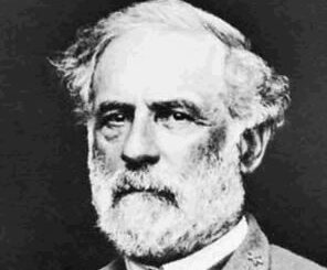
In an age devoid of modern communications methods and digital maps, military generals often made tactical decisions based on what they could see with their own eyes. In studying the Battle of Gettysburg, many people […]
MacDonald, Dettwiler and Associates Ltd. (“MDA” or the “Company”) (TSX: MDA), a global communications and information company, announced that it has been awarded a contract by the National Geospatial-Intelligence Agency (NGA) for its Geospatial Terminal […]
MacDonald, Dettwiler and Associates Ltd., a global communications and information company, today announced that it has been awarded a contract by the National Geospatial-Intelligence Agency (NGA) for its Geospatial Terminal Operations (GTO) requirement. Under the […]