• facebook
  • Twitter
  • Linkedin
  • Youtube
  • Linkedin Group
  • Post a Job
  • Post an Ad
  • Post an Event
  • Post a Directory Listing
  • Post a Press Release
  • Media Kit
  • My Account
  • Login
GoGeomatics
  • MAGAZINE
    • BIM & GIS
    • Community
    • Conference news
    • Earth Observation
    • Education & Careers
    • GEOAI
    • Announcements
    • Reality Capture & Lidar
    • Science
    • Technology
  • Directories
    • ASSOCIATION
    • INDUSTRY
    • EDUCATION
    • Open Data
  • EVENTS
    • GeoIgnite Events
    • Events Calendar
    • GoGeomatics Meetups
  • Services
    • Advertising
    • Marketing
    • Post a Job
    • Post an Ad
    • Post an Event
    • Post a Press Release
    • Post a Directory Listing
    • Media Kit
    • Web Design
  • Find a Job
  • Volunteer
    • Start a GoGeomatics Group
    • Editors & Writers Group
  • About Us
    • About Us
    • Contact Us
    • Frequently Asked Questions
  • Videos
Homedigital mapping

digital mapping

Reality Capture & Lidar

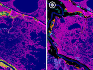
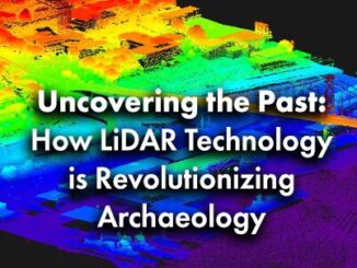
Uncovering the Past: How LiDAR Technology is Revolutionizing Archaeology

31 January 2025 Alicia Schrader | 3D Mapping

Introduction Mapping and history have been entwined since the first came to be. Maps have allowed humans to expand and record their exploration. Pushing the boundaries of territories and countries and recording the expansion of […]

BIM & GIS

Lidar Innovations and Trends to Look Out For in 2025

20 January 2025 Anusuya Datta | autonomous vehicles

The Lidar (Light Detection and Ranging) market has been experiencing rapid growth, with significant advancements in technology and an expanding range of applications. According to market reports, the global Lidar market size was valued at […]

Community

LidarCANEX 2025: Shaping the Future of Lidar and Reality Capture

26 November 2024 GoGeomatics Canada | 3D

Mark your calendars! LidarCANEX 2025, Canada’s premier Lidar Commercial Expo, is set to take place online on January 29-30, 2025. This highly anticipated event promises to bring together top lidar vendors, industry experts, and 3D […]

||||||||||
Technology

The SLA Presents Their Utility Mapping Ecosystem for Digital Workflows

26 June 2022 GoGeomatics Canada | 3D digital

Singapore is tapping into the potential of underground space. On March 23, 2022, participants of SUMSF were treated to a live stream presentation by Victor Khoo, Director of Singapore Land Authority (SLA). The topic of […]

||||
Technology

Geospatial Commission Demonstrates How To Apply Real Data To A Data Model

24 June 2022 GoGeomatics Canada | Amy Manefield

Preparation begins for NUAR rollout to selected areas. Amy Manefield, Head of Data Operations for the NUAR project sponsored by the Geospatial Commission, presented the topic of applying real data to a data model during […]

|||
Technology

DGT Combines Traditional and Advanced Technologies to advance Unground Mapping

21 June 2022 GoGeomatics Canada | BIM

Best practices come from using radar tomography to augment underground utility locating. SUMSF live stream on March 23, 2022, treated participants to a presentation by Michael Twohig, Subsurface Utility Mapping with DGT Associates, and Mitchell […]

|IMIA||IMIA|IMIA
Community

Future Trends with Dave McIlhagga, President of International Map Industry Association (IMIA)

9 June 2021 GoGeomatics Canada | cartography

GoGeomatics Community manager Tanya Tejassvi, had an interesting and insightful conversation with Dave McIlhagga – President of International Map Industry Association. Through the chat, we got to know more about IMIA, as well as Dave’s […]

||||||||
Technology

GeoIgnite 2020 Video: Cartographic Journeys with the Avenza Platform ~ Nick Burchell – Director- Avenza

4 October 2020 Elizabeth McCready | adobe creative cloud

Nick Burchell’s GeoIgnite talk ‘Cartographic Journeys with the Avenza Platform’ was one of the best graphically designed, creative, engaging, and well organised presentations at GeoIgnite 2020. […]

Posts pagination

« 1 2 3 »

Events

Notice
There are no upcoming events.

View All Events

Services

  • Post a Job
  • Post an Ad
  • Post an Event
  • Post a Directory Listing
  • Post a Press Release
  • Media Kit
  • My Account
  • Login

Jobs

Post a Job
  • Canada Maps and Poster Gallery Volunteer Leads — GeoIgnite 2026
    remote
  • GIS & Data Analytics Lead
    Beaumont, AB
  • Lead Surveyor, Projects/Arpenteur-géomètre principal, projets; arpenteuse-géomètre principale, projets
    North Bay, Thunder Bay
  • Senior GIS Developer
    Calgary, AB
View All Jobs
  • Directories
    • Associations Directory
    • Industry Directory
    • Education Programs
    • Open Data
  • Volunteer
    • Start a GoGeomatics Group
    • Editors & Writers Group
  • About Us
    • GoGeomatics Media Kit
    • Who We Are
    • Contact Us
    • FAQ’s
    • Advertising
    • Marketing
  • Subscribe
GoGeomatics
GoGeomatics is the largest and most popular communications hub promoting the Canadian geospatial community. The business was incorporated in 2011. GoGeomatics hosts over 100 fun, free, location technology networking events each year in cities across Canada.

© 2025 GoGeomatics

  • facebook
  • Twitter
  • Linkedin
  • Youtube
  • Linkedin Group