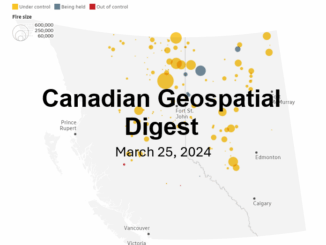
drones
GeoIgnite 2020 Video: How to challenge the Lasers-scanning market at the cost of a drone
Session: How to challenge the Lasers-scanning market at the cost of a drone and simple tools combined with Artificial Intelligence…
Further your Geospatial Education with these Online Programs
It’s that time of the year – back to school! This used to mean physically entering the classroom for most…
Your Canadian Geospatial Briefing for September 3rd: Is The GIS Market Vertically Challenged?; StatsCan using satellite data to estimate crop/yield production; Director of Data and Digital for the Government of Canada leaves to join AI Global; MDA Selected to Build Robotic Interfaces for the Canadarm3 on NASA-led Gateway; Teledyne Optech and LiDAR USA partner in dynamic new mobile UAV sensor integration; Drone test flight successfully delivers prescription drugs in Canada for the 1st time
Is The GIS Market Vertically Challenged? Will Cadell attended GoGeomatics GeoIgnite event last spring in Ottawa, ON. During his time…
Drones In Canada: the good, bad and ugly of the new tech
The Doc Zone from CBC has a new documentary out highlighting the rapid expansion of drones and how users both…
Chief Pilot for Cooke & Associates Inc Summarizes the Coming UAV regulation Changes in Canada
The new Canadian Air Regulations are complex pieces of literature for those unable to parse legalese. Luckily David Cooke, Chief…
Your Canadian Geospatial Briefing for March 4th: Sidewalk Labs; Vancouver Police force; MDA Forest Alert; DDC Top Venture 50; Joseph Klafter
The official GeoIgnite 2019 website has launched! The GeoIgnite 2019 website is your place to register to attend, exhibit, sponsor,…
Your Canadian Geospatial Briefing for February 18th: Markham Smart City pilot; Condor drone; Space Flight Laboratory; Canada’s Surface Combatant ships; goodwoodglobes; International Boundary Commission
Smart city technology will monitor Markham infrastructure Bell Canada and IBM Canada will be testing a new generation of systems…
Your Global Geospatial Briefing for February 12th: Data61; earth observation in the UK; supply chain data; AI in food delivery
When GIS is everywhere, what is it? As GIS becomes mainstream, it is aided by a proliferation of open-source, easily…
Your Canadian Geospatial Digest for January 21st: GeoIgnite 2019; Vancouver Island University; RADARSAT delay; new drone rules; UrtheCast; Teledyne; Maxar
GoGeomatics proudly presents: GeoIgnite 2019 GoGeomatics is thrilled to announce the first-ever GeoIgnite Conference in Ottawa! Taking place on June 18th and…
Unmanned Systems Canada Conference in Ottawa Fall of 2019
After a highly successful, informative and well attended UC18Vancouver, USC-STC is pleased to announce the dates for next years Annual…
How does modern tech fit in geomatics?
New technologies emerge all the time with lightning speed, but not all industries are equal in their rate of adopting…
Your Global Geospatial Briefing for September 25th: Geospatial cloud; UK satellites; Geo Week; drone technology; AI dam repair projects
Where are the Geospatial clouds? Will Cadell of Sparkgeo is often asked about geospatial platforms. Clouds are a great low…