• facebook
  • Twitter
  • Linkedin
  • Youtube
  • Linkedin Group
  • Post a Job
  • Post an Ad
  • Post an Event
  • Post a Directory Listing
  • Post a Press Release
  • Media Kit
  • My Account
  • Login
GoGeomatics
  • MAGAZINE
    • BIM & GIS
    • Community
    • Conference news
    • Earth Observation
    • Education & Careers
    • GEOAI
    • Announcements
    • Reality Capture & Lidar
    • Science
    • Technology
  • Directories
    • ASSOCIATION
    • INDUSTRY
    • EDUCATION
    • Open Data
  • EVENTS
    • GeoIgnite Events
    • Events Calendar
    • GoGeomatics Meetups
  • Services
    • Advertising
    • Marketing
    • Post a Job
    • Post an Ad
    • Post an Event
    • Post a Press Release
    • Post a Directory Listing
    • Media Kit
    • Web Design
  • Find a Job
  • Volunteer
    • Start a GoGeomatics Group
    • Editors & Writers Group
  • About Us
    • About Us
    • Contact Us
    • Frequently Asked Questions
  • Videos
HomeEMS

EMS

||||
Community

The Importance of Students & Young Professionals in Canada’s Geomatics Community

12 September 2016 GoGeomatics Canada | advice

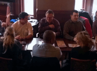
With the help of our sponsors GoGeomatics Canada is bringing students and young geospatial professionals together at 11 events from coast to coast (Complete list dates & locations is here).  Our September Back to School […]

|
Newsmakers & Press Releases

URISA Heads to Toronto for GIS-Pro 2016

9 September 2016 GoGeomatics Newsmakers | 2016

The Urban and Regional Information Systems Association (URISA), in partnership with its Ontario, Alberta and British Columbia Chapters, is pleased to share the details of GIS-Pro 2016: URISA’s 54th Annual Conference. The event will take […]

|||||
Technology

How Canadian Remote Sensing Was Made Commercially Successful & Exportable

7 September 2016 Robert Ryerson | activity

This piece started as a note on some of my experience as an international consultant in remote sensing specifically and geomatics more generally. But as I looked more and more at the role of consulting, […]

|
Technology

LiDAR in Canada: Conversation with Dr. Chris Hopkinson Research Chair Remote Sensing University of Lethbridge

6 September 2016 Robert Maher | 3D

The author Bob Maher (BM) and Chris Hopkinson (CH) both worked as scientists at the Appied Geomatics Reearch Group (AGRG) between 2004-2011. Five years later, it was time to catch up. Chris is currently Research […]

No Picture
Community

GIS Health Studies: Conduct Spatial Exposure Assessments

5 September 2016 Anders Erickson | 2016

Interested in how to conduct different types of spatial exposure assessments for air pollution or other exposures to a population?  PHDA04: Spatial Epidemiology and Outbreak Detection is a great place to start. Exposure assessment is the […]

BCIT GIS student project Tetrad||BCIT GIS Student Posters|
Education & Careers

Become a BCIT GIS Student Project / Practicum Sponsor

1 September 2016 Karl Kliparchuk | 2017

The BCIT GIS department has been graduating students for 25+ years.  Our students come from BC, but as well, across Canada and international.  Our program is known to be very demanding, and creates students that […]

No Picture
Newsmakers & Press Releases

Airobotics Selects SimActive’s Photogrammetry Software for its Automated Industrial Drone Solution

30 August 2016 GoGeomatics Newsmakers | 2016

Montreal, Canada, August 30th, 2016 – SimActive Inc., a world-leading developer of photogrammetry software, is pleased to announce that Airobotics has chosen Correlator3D™ for its drone platforms. The software will be used to derive mapping […]

No Picture
Newsmakers & Press Releases

International Spatial Symposium in Quebec City: CAMUSS 2016

29 August 2016 GoGeomatics Newsmakers | 2016

You are cordially invited to participate in the Second International Symposium on Cellular Automata Modeling for Urban and Spatial Systems (CAMUSS 2016) that will be held in a beautiful UNESCO World Heritage Site, Quebec City, […]

Posts pagination

« 1 … 7 8 9 … 57 »

Events

Notice
There are no upcoming events.

View All Events

Services

  • Post a Job
  • Post an Ad
  • Post an Event
  • Post a Directory Listing
  • Post a Press Release
  • Media Kit
  • My Account
  • Login

Jobs

Post a Job
  • Canada Maps and Poster Gallery Volunteer Leads — GeoIgnite 2026
    remote
  • Software Engineer – Geographic Information System (GIS)
    Ottawa, ON
  • GIS Data Quality Analyst
    Burnaby, British Columbia
  • GIS Cartographer
    Montreal, QC
View All Jobs
  • Directories
    • Associations Directory
    • Industry Directory
    • Education Programs
    • Open Data
  • Volunteer
    • Start a GoGeomatics Group
    • Editors & Writers Group
  • About Us
    • GoGeomatics Media Kit
    • Who We Are
    • Contact Us
    • FAQ’s
    • Advertising
    • Marketing
  • Subscribe
GoGeomatics
GoGeomatics is the largest and most popular communications hub promoting the Canadian geospatial community. The business was incorporated in 2011. GoGeomatics hosts over 100 fun, free, location technology networking events each year in cities across Canada.

© 2025 GoGeomatics

  • facebook
  • Twitter
  • Linkedin
  • Youtube
  • Linkedin Group