• facebook
  • Twitter
  • Linkedin
  • Youtube
  • Linkedin Group
  • Post a Job
  • Post an Ad
  • Post an Event
  • Post a Directory Listing
  • Post a Press Release
  • Media Kit
  • My Account
  • Login
GoGeomatics
  • MAGAZINE
    • BIM & GIS
    • Community
    • Conference news
    • Earth Observation
    • Education & Careers
    • GEOAI
    • Announcements
    • Reality Capture & Lidar
    • Science
    • Technology
  • Directories
    • ASSOCIATION
    • INDUSTRY
    • EDUCATION
    • Open Data
  • EVENTS
    • GeoIgnite Events
    • Events Calendar
    • GoGeomatics Meetups
  • Services
    • Advertising
    • Marketing
    • Post a Job
    • Post an Ad
    • Post an Event
    • Post a Press Release
    • Post a Directory Listing
    • Media Kit
    • Web Design
  • Find a Job
  • Volunteer
    • Start a GoGeomatics Group
    • Editors & Writers Group
  • About Us
    • About Us
    • Contact Us
    • Frequently Asked Questions
  • Videos
Homeflood

flood

|||
Technology

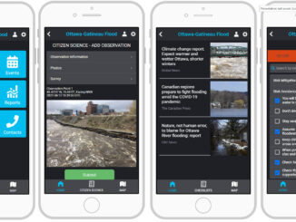
How Deploy Solutions can help bridge the communications gap in times of climate change crisis

16 April 2021 Nicholas Kellet | big data

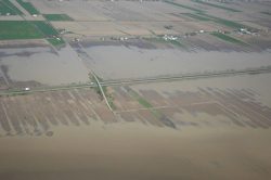
Our Changing Climate The world we live in is changing, with global warming reshaping climate and causing more frequent, more extreme impacts and natural disasters. Climate change is the driving environmental challenge of our time […]

|||||
Technology

Canadian Geospatial Briefing March 29th: Bringing 18th Century Fort to Life; Self-Driving Shuttle Bus; New Integration Within Cityworks Platform; University of Sherbrooke receives more than $28 million for artificial intelligence research; Real-time water levels now available on district web mapping portal in Muskoka, Ontario; Whole new agricultural revolution

29 March 2021 GoGeomatics Canada | 3D modeling

Archaeologist Brings 18th Century Fort to Life with LiDAR and 3D Modeling. Dr. Jonathan Fowler, a Canadian archaeologist at Saint Mary’s University in Halifax is using historic maps combined with a modern terrain model of […]

||||
Technology

Building Software Solutions for Climate Change: Closing the communication gap between citizens and trusted authorities before, during, or after a disaster

19 March 2021 Nicholas Kellet | bigdata

A Climate Change Problem: The Communication Gap between Citizens and Authorities At a time of rising climate change impacts, there is a vital and growing need to prepare for, respond to, and recover from natural […]

|||||
Technology

Your Canadian Geospatial Briefing for May 21st: Jim Watson at GeoIgnite; Flood maps; Maxar and DARPA; RADARSAT

20 May 2019 GoGeomatics Canada | flood

Mayor Jim Watson to open GeoIgnite 2019  GeoIgnite is excited to announce that Mayor Jim Watson will be introducing the plenary day of GeoIgnite 2019! As the new national conference is taking place in Canada’s […]

|||||
Technology

Your Canadian Geospatial Briefing for June 25th: Canadian GIS Program Closing; Arctic Coast Guard; Canadian Gov’t and Big Data; Radarsat Satellites; flood imagery; Investing in Canada Plan

25 June 2018 GoGeomatics Canada | Arctic

Why is Red River College closing its GIS program? “Low Industry and labour market demand and difficulty attracting students” as well as budget costs to post-secondary schools in Manitoba have been cited as causes in […]

||||||||||||||
Technology

Geomatics Web Services Used in Recent Quebec Floods

6 September 2017 Nicolas Gignac | disaster

Editors note: This article has been jointly written by Nicolas Gignac and Serge Legaré from the Ministry of Public Safety in Quebec. Cet article est aussi disponible en français : http://www.quebecgeographique.gouv.qc.ca/approfondir/bibliotheque/geoinfo/geoinfo-juillet-2017.asp During Spring 2017, a major […]

Posts pagination

« 1 2

Events

Notice
There are no upcoming events.

View All Events

Services

  • Post a Job
  • Post an Ad
  • Post an Event
  • Post a Directory Listing
  • Post a Press Release
  • Media Kit
  • My Account
  • Login

Jobs

Post a Job
  • Canada Maps and Poster Gallery Volunteer Leads — GeoIgnite 2026
    remote
  • GIS & Data Analytics Lead
    Beaumont, AB
  • Lead Surveyor, Projects/Arpenteur-géomètre principal, projets; arpenteuse-géomètre principale, projets
    North Bay, Thunder Bay
  • Senior GIS Developer
    Calgary, AB
View All Jobs
  • Directories
    • Associations Directory
    • Industry Directory
    • Education Programs
    • Open Data
  • Volunteer
    • Start a GoGeomatics Group
    • Editors & Writers Group
  • About Us
    • GoGeomatics Media Kit
    • Who We Are
    • Contact Us
    • FAQ’s
    • Advertising
    • Marketing
  • Subscribe
GoGeomatics
GoGeomatics is the largest and most popular communications hub promoting the Canadian geospatial community. The business was incorporated in 2011. GoGeomatics hosts over 100 fun, free, location technology networking events each year in cities across Canada.

© 2025 GoGeomatics

  • facebook
  • Twitter
  • Linkedin
  • Youtube
  • Linkedin Group