• facebook
  • Twitter
  • Linkedin
  • Youtube
  • Linkedin Group
  • Post a Job
  • Post an Ad
  • Post an Event
  • Post a Directory Listing
  • Post a Press Release
  • Media Kit
  • My Account
  • Login
GoGeomatics
  • MAGAZINE
    • BIM & GIS
    • Community
    • Conference news
    • Earth Observation
    • Education & Careers
    • GEOAI
    • Announcements
    • Reality Capture & Lidar
    • Science
    • Technology
  • Directories
    • ASSOCIATION
    • INDUSTRY
    • EDUCATION
    • Open Data
  • EVENTS
    • GeoIgnite Events
    • Events Calendar
    • GoGeomatics Meetups
  • Services
    • Advertising
    • Marketing
    • Post a Job
    • Post an Ad
    • Post an Event
    • Post a Press Release
    • Post a Directory Listing
    • Media Kit
    • Web Design
  • Find a Job
  • Volunteer
    • Start a GoGeomatics Group
    • Editors & Writers Group
  • About Us
    • About Us
    • Contact Us
    • Frequently Asked Questions
  • Videos
HomeFOCUS

FOCUS

High Resolution Mapping Along the Coastal Zone - https://geomatics.one
Newsmakers & Press Releases

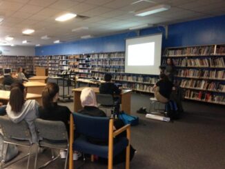
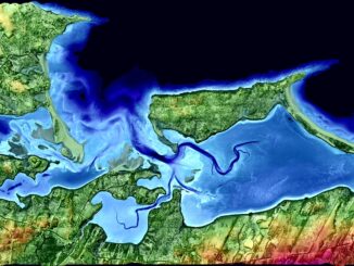
Atlantic Canada: COGS: Geomatics Professionals Coming to Discuss High Resolution Coastal Mapping

30 January 2017 GoGeomatics Newsmakers | 2017

High Resolution Coastal Zone Mapping This collaborative effort by GANS & the CIG will engage the geospatial community & increase awareness on the value that geospatial data provides to effective decision making January 30, 2017 (Halifax, NS) – Next week […]

Education & Careers

Graph Databases – Recent development in Neo4j may help accommodate the Geospatial Community

26 January 2017 Emmanuel Stefanakis | 2016

Graph Databases and GIS & Technology (GIS&T) In the era of big data, graph databases are becoming very popular as they can address important challenges in terms of data size and data complexity. A graph […]

Community

GIS in Public Health: Kingston GoGeomatics Social Thursday, January 19

16 January 2017 GoGeomatics Canada | 2017

Free GIS & Public Health  Talk in Kingston Thursday, January 19, 2017 6:00 PM Sir John A Public House 343 King Street E, Kingston, ON   Brian Mosley GISP is a GIS Analyst with KFL&A […]

No Picture
Technology

Canadian Geomatics Innovation: Ecere Develops a Next Generation GIS

11 January 2017 Ozair Khan | 2014

Not many companies undertake the ambitious goal of creating a new geospatial software suite from scratch. Ecere, a Canadian company based in Gatineau, Québec has been developing a software platform that has positioned them to […]

Canadian flag||||||
Community

List of Canadian Geomatics Conferences and Events for 2017

20 December 2016 GoGeomatics Canada | 2017

This is our list Canadian geomatics conferences and events for 2017. Here you will find events pertaining to GIS, remote sensing, surveying, cartography, and informatics. We’re always updating this list, so if you have a […]

|||
Technology

Predicting the Future of the GIS in Canada

1 December 2016 Gordon Plunkett | 2015

Editors note: This article has been jointly written by Bruce McCormack and Gordon Plunkett. Bios can be found at the bottom of the article. Most people like to predict the future. People are interested in […]

|||
Community

Contrasting: GIS & Geomatics Education in Canada and China

30 November 2016 Francis Guo | analysis

I have studied Geographic Information Systems (GIS) in both Canada and China. Last summer I completed my master in geography at University of Waterloo. In this article I will draw upon my experiences in China and […]

||||||||||
Education & Careers

Easy Access to Data: The CGDI Initiative

28 November 2016 Elaha Akrami | 2013

The Canadian Geospatial Data Infrastructure (CGDI) is an initiative of Natural Resources Canada that began in 2001. The CGDI does not refer to a specific database, but rather a collection of Canadian geospatial resources available […]

Posts pagination

« 1 2 3 4 … 34 »

Events

Notice
There are no upcoming events.

View All Events

Services

  • Post a Job
  • Post an Ad
  • Post an Event
  • Post a Directory Listing
  • Post a Press Release
  • Media Kit
  • My Account
  • Login

Jobs

Post a Job
  • Canada Maps and Poster Gallery Volunteer Leads — GeoIgnite 2026
    remote
  • GIS & Data Analytics Lead
    Beaumont, AB
  • Lead Surveyor, Projects/Arpenteur-géomètre principal, projets; arpenteuse-géomètre principale, projets
    North Bay, Thunder Bay
  • Senior GIS Developer
    Calgary, AB
View All Jobs
  • Directories
    • Associations Directory
    • Industry Directory
    • Education Programs
    • Open Data
  • Volunteer
    • Start a GoGeomatics Group
    • Editors & Writers Group
  • About Us
    • GoGeomatics Media Kit
    • Who We Are
    • Contact Us
    • FAQ’s
    • Advertising
    • Marketing
  • Subscribe
GoGeomatics
GoGeomatics is the largest and most popular communications hub promoting the Canadian geospatial community. The business was incorporated in 2011. GoGeomatics hosts over 100 fun, free, location technology networking events each year in cities across Canada.

© 2025 GoGeomatics

  • facebook
  • Twitter
  • Linkedin
  • Youtube
  • Linkedin Group