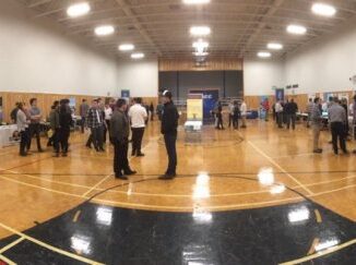
My COGS GIS Education, Part II
In my first article, I introduced the how and why I chose to attend COGS from the fall of 2014 to spring 2016. In Part 2, I wanted to give some insight into the first-year […]
I often contemplate what it would have been like working at the same job for an entire career. Mind you, the thought of the same job day in and day out never appealed to me. I’m […]
These days drones are all the rage. Nevertheless, there are other ways to collect data from the sky! Blimps, balloons and kites are alternative was to collecting data or remote-sensing imagery. These are great unconventional solutions for […]
Since December 15, 2016, the new Galileo global satellite navigation system has been up and running. Unfortunately, there are some technical difficulties on the horizon, having to do with the clocks that are on […]
It is rare to learn of a GIS company in which much R&D is done up front to create the programming language used to build its tools. Ecere, a Canadian company based in Gatineau, Québec, […]
Not many companies undertake the ambitious goal of creating a new geospatial software suite from scratch. Ecere, a Canadian company based in Gatineau, Québec has been developing a software platform that has positioned them to […]
This is our list Canadian geomatics conferences and events for 2017. Here you will find events pertaining to GIS, remote sensing, surveying, cartography, and informatics. We’re always updating this list, so if you have a […]
I have studied Geographic Information Systems (GIS) in both Canada and China. Last summer I completed my master in geography at University of Waterloo. In this article I will draw upon my experiences in China and […]